地理情報要素編目方法学(Iso 19110)
詳細:www.iso.org/iso/home/store/Catalogue_TC/Catalogue_Detail.htm?csnumber=39965
メタデータエディタ
この基準は,3つのビューを用いて符号化することができる.
ビュー:簡単(デフォルト)
このビューは%1個のオプションカードから構成されています。
このビューは、現在のレコードになくても、以下の要素を追加することを可能にする。
コード(GFC:コード)
Codelist(gfc:listedValue)
タブ:簡単(デフォルト)
このオプションカードは、XMLメタデータレコードの要素を表示します。
部分:機能ディレクトリ記述
参考:iso 19110-elem-gfc-fc_FeatureCatalogue-a 4 de 444 fdd 9 a 6 e 86 e 8 ba 63 bb 96 be 363 c
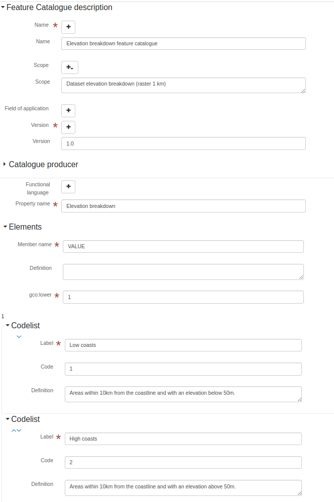
名前.名前.
Feature catalogue name- XPath
/gfc:fc_FeatureCatalogue/gmx:名前
参考:iso 19110-elem-gmx-name-5 ec 0 c 4442 ad 2 b 9494636103 e 556 d 401
名前.名前.
Feature catalogue name- XPath
/gfc:fc_FeatureCatalogue/gfc:名前
参考:iso 19110-elem-gfc-name-134285 dc 9 b 9 a 3268556039 e 2 fe 3 f 370 e
範囲.範囲.
Scope definition- XPath
/gfc:fc_FeatureCatalogue/gmx:Scope
参考:iso 19110-elem-gmx-scope-14 efac6982297 b 09 ba 1324 e 8013809 f
範囲.範囲.
Scope definition- XPath
/gfc:fc_FeatureCatalogue/gfc:Scope
参考:iso 19110-elem-gfc-scope-4 f 044 fce 55 b 8 e 0 b 6 dd 0 d 77516 ad 9 e 66 d
適用分野.
Field of application- XPath
/gfc:fc_FeatureCatalogue/gmx:fieldOfApplication
参考:iso 19110-elem-gmx-fieldOfApplication-66508 d 1 f 139317 e 01 e 1 decd 095915428
適用分野.
Field of application- XPath
/gfc:fc_FeatureCatalogue/gfc:fieldOfApplication
参考:iso 19110-elem-gfc-fieldOfApplication-548 e 0631 e 3 ea 92 f 7 dd 05 ac 533 b 6 c 14 d 2
バージョン
Catalogue version- XPath
/gfc:fc_FeatureCatalogue/gmx:versionNumber
参考:iso 19110-elem-gmx-versionNumber-075201 f 18225 aec 432 b 46 c 75 a 93589 a 2
バージョン
Catalogue version- XPath
/gfc:fc_FeatureCatalogue/gfc:versionNumber
参考:iso 19110-elem-gfc-versionNumber-d 66 ec 9 fd 5 c 22 c 70 a 69 d 2 b 759 d 66 cc 4 f
日取り
Catalogue date- XPath
/gfc:fc_FeatureCatalogue/gmx:versionDate
参考:iso 19110-elem-gmx-versionDate-6 c 27 e 2 ee 0 b 2 da 4 ab 1 aea 9 ef 374 bc 08 f
カタログ作成者
Catalogue responsible- XPath
/gfc:fc_FeatureCatalogue/gfc:Producer
参考:iso 19110-elem-gfc-Producer-5 a 13 bFab 8 b 07441 bc 9 f 9 f 71 dcfdf 7 f 6 c
関数式言語
- XPath
/gfc:fc_FeatureCatalogue/gfc:functionalLanguage
参考:iso 19110-elem-gfc-functionalLanguage-7 a 21 d 9 c 35 ed 9 c 400 c 40959 ede 97 b 8 d 76
属性説明
Property description- XPath
/gfc:fc_FeatureCatalogue/gfc:FeatureType
参考:iso 19110-elem-gfc-feature ureType-d 6099 a 684 b 15337451388 dd 46048 c 48 f
- タイプ
提案する.
ビュー:完全(高度)
このビューは%1個のオプションカードから構成されています。
タブ:完全(高度)
このオプションカードは、XMLメタデータレコード内の要素を表示し、アーキテクチャ(XSD)で定義されたすべての要素を追加するコントロールを提供します。
部分:属性表説明
Attribute table description参考:iso 19110-elem-gfc-fc_FeatureType-38 ad 06 d 5 e 87 d 9 bf 33 d 5 f 111 e 7 bca 0 b 4
部分:機能ディレクトリ記述
参考:iso 19110-elem-gfc-fc_FeatureCatalogue-a 4 de 444 fdd 9 a 6 e 86 e 8 ba 63 bb 96 be 363 c
ビュー:XML(XML)
このビューは%1個のオプションカードから構成されています。
タブ:XML(XML)
このオプションカードは、XMLメタデータレコード内の要素を表示し、アーキテクチャ(XSD)で定義されたすべての要素を追加するコントロールを提供します。
アーキテクチャ技術の詳細情報
- 標準識別子.
Iso 19110
- バージョン
1.0
- 構造的位置
http://www.isotc211.org/2005/gfc http://www.isotc211.org/2005/gfc/gfc.xsd
- 構造命名空間
- モード検出モード
元素(根)
- アーキテクチャ検出要素
GFC:fc_FeatureCatalogue
GFC:fc_FeatureType
標準品.
標準のすべての利用可能な要素のリスト。
テキスト
- 名前.名前.
GCO:文字列
- 説明する.
下基数.
- 名前.名前.
GCO:低いです
- 説明する.
<gco:lower xmlns:gfc="http://www.isotc211.org/2005/gfc"
           xmlns:xsi="http://www.w3.org/2001/XMLSchema-instance">
   <gco:Integer>1</gco:Integer>
</gco:lower>
理由がない
- 名前.名前.
GCO:NilReason
- 説明する.
射程距離.
- 名前.名前.
GCO:範囲
- 説明する.
<gco:range xmlns:gfc="http://www.isotc211.org/2005/gfc"
           xmlns:xsi="http://www.w3.org/2001/XMLSchema-instance">
   <gco:MultiplicityRange>
      <gco:lower>
         <gco:Integer>1</gco:Integer>
      </gco:lower>
      <gco:upper>
         <gco:UnlimitedInteger isInfinite="false" xsi:nil="false">1
                    </gco:UnlimitedInteger>
      </gco:upper>
   </gco:MultiplicityRange>
</gco:range>
上基数.
- 名前.名前.
GCO:上部
- 説明する.
<gco:upper xmlns:gfc="http://www.isotc211.org/2005/gfc"
           xmlns:xsi="http://www.w3.org/2001/XMLSchema-instance">
   <gco:UnlimitedInteger isInfinite="false" xsi:nil="false">1
                    </gco:UnlimitedInteger>
</gco:upper>
影響
- 名前.名前.
GFC:affectsValueOf
- 説明する.
別名.
- 名前.名前.
GFC:別名
- 説明する.
基数.
- 名前.名前.
GFC:基数
- 説明する.
<gfc:cardinality xmlns:gfc="http://www.isotc211.org/2005/gfc"
                 xmlns:xsi="http://www.w3.org/2001/XMLSchema-instance">
   <gco:Multiplicity>
      <gco:range>
         <gco:MultiplicityRange>
            <gco:lower>
               <gco:Integer>1</gco:Integer>
            </gco:lower>
            <gco:upper>
               <gco:UnlimitedInteger isInfinite="false" xsi:nil="false">1
                    </gco:UnlimitedInteger>
            </gco:upper>
         </gco:MultiplicityRange>
      </gco:range>
   </gco:Multiplicity>
</gfc:cardinality>
元素.元素
- 名前.名前.
GFC:特徴ベクター(CarrierOf Characteristic)
- 説明する.
<gfc:carrierOfCharacteristics xmlns:gfc="http://www.isotc211.org/2005/gfc"
                              xmlns:xsi="http://www.w3.org/2001/XMLSchema-instance">
   <gfc:FC_FeatureAttribute>
      <gfc:memberName>
         <gco:LocalName>VALUE</gco:LocalName>
      </gfc:memberName>
      <gfc:definition>
         <gco:CharacterString/>
      </gfc:definition>
      <gfc:cardinality>
         <gco:Multiplicity>
            <gco:range>
               <gco:MultiplicityRange>
                  <gco:lower>
                     <gco:Integer>1</gco:Integer>
                  </gco:lower>
                  <gco:upper>
                     <gco:UnlimitedInteger isInfinite="false" xsi:nil="false">1
                    </gco:UnlimitedInteger>
                  </gco:upper>
               </gco:MultiplicityRange>
            </gco:range>
         </gco:Multiplicity>
      </gfc:cardinality>
      <gfc:featureType/>
      <gfc:valueMeasurementUnit>
         <gml:UnitDefinition xmlns:gml="http://www.opengis.net/gml" gml:id="unknown">
            <gml:description/>
            <gml:identifier codeSpace="unknown"/>
         </gml:UnitDefinition>
      </gfc:valueMeasurementUnit>
      <gfc:listedValue>
         <gfc:FC_ListedValue>
            <gfc:label>
               <gco:CharacterString>Low coasts</gco:CharacterString>
            </gfc:label>
            <gfc:code>
               <gco:CharacterString>1</gco:CharacterString>
            </gfc:code>
            <gfc:definition>
               <gco:CharacterString>Areas within 10km from the coastline and with an elevation
                  below 50m.
                </gco:CharacterString>
            </gfc:definition>
         </gfc:FC_ListedValue>
      </gfc:listedValue>
      <gfc:listedValue>
         <gfc:FC_ListedValue>
            <gfc:label>
               <gco:CharacterString>High coasts</gco:CharacterString>
            </gfc:label>
            <gfc:code>
               <gco:CharacterString>2</gco:CharacterString>
            </gfc:code>
            <gfc:definition>
               <gco:CharacterString>Areas within 10km from the coastline and with an elevation
                  above 50m.
                </gco:CharacterString>
            </gfc:definition>
         </gfc:FC_ListedValue>
      </gfc:listedValue>
      <gfc:listedValue>
         <gfc:FC_ListedValue>
            <gfc:label>
               <gco:CharacterString>Inlands</gco:CharacterString>
            </gfc:label>
            <gfc:code>
               <gco:CharacterString>3</gco:CharacterString>
            </gfc:code>
            <gfc:definition>
               <gco:CharacterString>Areas between 0 and 200 m outside the coastal strip.
                </gco:CharacterString>
            </gfc:definition>
         </gfc:FC_ListedValue>
      </gfc:listedValue>
      <gfc:listedValue>
         <gfc:FC_ListedValue>
            <gfc:label>
               <gco:CharacterString>Uplands</gco:CharacterString>
            </gfc:label>
            <gfc:code>
               <gco:CharacterString>4</gco:CharacterString>
            </gfc:code>
            <gfc:definition>
               <gco:CharacterString>Zones between 200 and 500 m plus the flat areas between 500 and
                  1000m.
                </gco:CharacterString>
            </gfc:definition>
         </gfc:FC_ListedValue>
      </gfc:listedValue>
      <gfc:listedValue>
         <gfc:FC_ListedValue>
            <gfc:label>
               <gco:CharacterString>Mountains</gco:CharacterString>
            </gfc:label>
            <gfc:code>
               <gco:CharacterString>5</gco:CharacterString>
            </gfc:code>
            <gfc:definition>
               <gco:CharacterString>Slopy areas between 500 and 1000m and all the areas over
                  1000m.
                </gco:CharacterString>
            </gfc:definition>
         </gfc:FC_ListedValue>
      </gfc:listedValue>
      <gfc:valueType>
         <gco:TypeName>
            <gco:aName>
               <gco:CharacterString>INTEGER</gco:CharacterString>
            </gco:aName>
         </gco:TypeName>
      </gfc:valueType>
   </gfc:FC_FeatureAttribute>
</gfc:carrierOfCharacteristics>
コード
- 名前.名前.
GFC:コード
- 説明する.
以下の条件に拘束される
- 名前.名前.
GFC:ConstrainedBy
- 説明する.
定義する.
- 名前.名前.
GFC:定義
- 説明する.
定義参照
- 名前.名前.
GFC:参照の定義
- 説明する.
定義源
- 名前.名前.
GFC:ソースの定義
- 説明する.
説明する.
- 名前.名前.
GFC:説明
- 説明する.
関連役
- 名前.名前.
Gfc:fc_AssociationRole
- 説明する.
拘束する.
- 名前.名前.
GFC:FC_Constraint
- 説明する.
要素関連
- 名前.名前.
GFC:fc_FeatureAssociation
- 説明する.
属性
- 名前.名前.
GFC:fc_FeatureAttribute
- 説明する.
<gfc:FC_FeatureAttribute xmlns:gfc="http://www.isotc211.org/2005/gfc"
                         xmlns:xsi="http://www.w3.org/2001/XMLSchema-instance">
   <gfc:memberName>
      <gco:LocalName>VALUE</gco:LocalName>
   </gfc:memberName>
   <gfc:definition>
      <gco:CharacterString/>
   </gfc:definition>
   <gfc:cardinality>
      <gco:Multiplicity>
         <gco:range>
            <gco:MultiplicityRange>
               <gco:lower>
                  <gco:Integer>1</gco:Integer>
               </gco:lower>
               <gco:upper>
                  <gco:UnlimitedInteger isInfinite="false" xsi:nil="false">1
                    </gco:UnlimitedInteger>
               </gco:upper>
            </gco:MultiplicityRange>
         </gco:range>
      </gco:Multiplicity>
   </gfc:cardinality>
   <gfc:featureType/>
   <gfc:valueMeasurementUnit>
      <gml:UnitDefinition xmlns:gml="http://www.opengis.net/gml" gml:id="unknown">
         <gml:description/>
         <gml:identifier codeSpace="unknown"/>
      </gml:UnitDefinition>
   </gfc:valueMeasurementUnit>
   <gfc:listedValue>
      <gfc:FC_ListedValue>
         <gfc:label>
            <gco:CharacterString>Low coasts</gco:CharacterString>
         </gfc:label>
         <gfc:code>
            <gco:CharacterString>1</gco:CharacterString>
         </gfc:code>
         <gfc:definition>
            <gco:CharacterString>Areas within 10km from the coastline and with an elevation
                  below 50m.
                </gco:CharacterString>
         </gfc:definition>
      </gfc:FC_ListedValue>
   </gfc:listedValue>
   <gfc:listedValue>
      <gfc:FC_ListedValue>
         <gfc:label>
            <gco:CharacterString>High coasts</gco:CharacterString>
         </gfc:label>
         <gfc:code>
            <gco:CharacterString>2</gco:CharacterString>
         </gfc:code>
         <gfc:definition>
            <gco:CharacterString>Areas within 10km from the coastline and with an elevation
                  above 50m.
                </gco:CharacterString>
         </gfc:definition>
      </gfc:FC_ListedValue>
   </gfc:listedValue>
   <gfc:listedValue>
      <gfc:FC_ListedValue>
         <gfc:label>
            <gco:CharacterString>Inlands</gco:CharacterString>
         </gfc:label>
         <gfc:code>
            <gco:CharacterString>3</gco:CharacterString>
         </gfc:code>
         <gfc:definition>
            <gco:CharacterString>Areas between 0 and 200 m outside the coastal strip.
                </gco:CharacterString>
         </gfc:definition>
      </gfc:FC_ListedValue>
   </gfc:listedValue>
   <gfc:listedValue>
      <gfc:FC_ListedValue>
         <gfc:label>
            <gco:CharacterString>Uplands</gco:CharacterString>
         </gfc:label>
         <gfc:code>
            <gco:CharacterString>4</gco:CharacterString>
         </gfc:code>
         <gfc:definition>
            <gco:CharacterString>Zones between 200 and 500 m plus the flat areas between 500 and
                  1000m.
                </gco:CharacterString>
         </gfc:definition>
      </gfc:FC_ListedValue>
   </gfc:listedValue>
   <gfc:listedValue>
      <gfc:FC_ListedValue>
         <gfc:label>
            <gco:CharacterString>Mountains</gco:CharacterString>
         </gfc:label>
         <gfc:code>
            <gco:CharacterString>5</gco:CharacterString>
         </gfc:code>
         <gfc:definition>
            <gco:CharacterString>Slopy areas between 500 and 1000m and all the areas over
                  1000m.
                </gco:CharacterString>
         </gfc:definition>
      </gfc:FC_ListedValue>
   </gfc:listedValue>
   <gfc:valueType>
      <gco:TypeName>
         <gco:aName>
            <gco:CharacterString>INTEGER</gco:CharacterString>
         </gco:aName>
      </gco:TypeName>
   </gfc:valueType>
</gfc:FC_FeatureAttribute>
機能ディレクトリ記述
- 名前.名前.
GFC:fc_FeatureCatalogue
- 説明する.
<gfc:FC_FeatureCatalogue xmlns:gfc="http://www.isotc211.org/2005/gfc"
                         uuid="411cd05b-9a79-45f2-b39f-0b344a9f35af"
                         xsi:schemaLocation="http://www.isotc211.org/2005/gfc http://www.isotc211.org/2005/gfc/gfc.xsd">
   <gfc:name>
      <gco:CharacterString>Elevation breakdown feature catalogue</gco:CharacterString>
   </gfc:name>
   <gfc:scope>
      <gco:CharacterString>Dataset elevation breakdown (raster 1 km)</gco:CharacterString>
   </gfc:scope>
   <gfc:versionNumber>
      <gco:CharacterString>1.0</gco:CharacterString>
   </gfc:versionNumber>
   <gfc:versionDate>
      <gco:DateTime>2012-11-05T10:56:11</gco:DateTime>
   </gfc:versionDate>
   <gfc:producer>
      <gmd:CI_ResponsibleParty>
         <gmd:individualName>
            <gco:CharacterString>European Environment Agency</gco:CharacterString>
         </gmd:individualName>
         <gmd:organisationName>
            <gco:CharacterString/>
         </gmd:organisationName>
         <gmd:positionName>
            <gco:CharacterString/>
         </gmd:positionName>
         <gmd:contactInfo>
            <gmd:CI_Contact>
               <gmd:address>
                  <gmd:CI_Address>
                     <gmd:deliveryPoint>
                        <gco:CharacterString>Kongens Nytorv 6</gco:CharacterString>
                     </gmd:deliveryPoint>
                     <gmd:city>
                        <gco:CharacterString>Copenhagen</gco:CharacterString>
                     </gmd:city>
                     <gmd:administrativeArea>
                        <gco:CharacterString>K</gco:CharacterString>
                     </gmd:administrativeArea>
                     <gmd:postalCode>
                        <gco:CharacterString>1050</gco:CharacterString>
                     </gmd:postalCode>
                     <gmd:country>
                        <gco:CharacterString>Denmark</gco:CharacterString>
                     </gmd:country>
                     <gmd:electronicMailAddress>
                        <gco:CharacterString>mauro.michielon@eea.europa.eu</gco:CharacterString>
                     </gmd:electronicMailAddress>
                  </gmd:CI_Address>
               </gmd:address>
            </gmd:CI_Contact>
         </gmd:contactInfo>
         <gmd:role>
            <gmd:CI_RoleCode codeListValue="pointOfContact" codeList="CI_RoleCode"/>
         </gmd:role>
      </gmd:CI_ResponsibleParty>
   </gfc:producer>
   <gfc:featureType>
      <gfc:FC_FeatureType>
         <gfc:typeName>
            <gco:LocalName>Elevation breakdown</gco:LocalName>
         </gfc:typeName>
         <gfc:definition>
            <gco:CharacterString>The Elevation breakdown is used to allocate Land cover changes into
          homogeneous areas as function of height, slope and distance to the sea.
        </gco:CharacterString>
         </gfc:definition>
         <gfc:isAbstract>
            <gco:Boolean>false</gco:Boolean>
         </gfc:isAbstract>
         <gfc:featureCatalogue/>
         <gfc:carrierOfCharacteristics>
            <gfc:FC_FeatureAttribute>
               <gfc:memberName>
                  <gco:LocalName>VALUE</gco:LocalName>
               </gfc:memberName>
               <gfc:definition>
                  <gco:CharacterString/>
               </gfc:definition>
               <gfc:cardinality>
                  <gco:Multiplicity>
                     <gco:range>
                        <gco:MultiplicityRange>
                           <gco:lower>
                              <gco:Integer>1</gco:Integer>
                           </gco:lower>
                           <gco:upper>
                              <gco:UnlimitedInteger isInfinite="false" xsi:nil="false">1
                    </gco:UnlimitedInteger>
                           </gco:upper>
                        </gco:MultiplicityRange>
                     </gco:range>
                  </gco:Multiplicity>
               </gfc:cardinality>
               <gfc:featureType/>
               <gfc:valueMeasurementUnit>
                  <gml:UnitDefinition xmlns:gml="http://www.opengis.net/gml" gml:id="unknown">
                     <gml:description/>
                     <gml:identifier codeSpace="unknown"/>
                  </gml:UnitDefinition>
               </gfc:valueMeasurementUnit>
               <gfc:listedValue>
                  <gfc:FC_ListedValue>
                     <gfc:label>
                        <gco:CharacterString>Low coasts</gco:CharacterString>
                     </gfc:label>
                     <gfc:code>
                        <gco:CharacterString>1</gco:CharacterString>
                     </gfc:code>
                     <gfc:definition>
                        <gco:CharacterString>Areas within 10km from the coastline and with an elevation
                  below 50m.
                </gco:CharacterString>
                     </gfc:definition>
                  </gfc:FC_ListedValue>
               </gfc:listedValue>
               <gfc:listedValue>
                  <gfc:FC_ListedValue>
                     <gfc:label>
                        <gco:CharacterString>High coasts</gco:CharacterString>
                     </gfc:label>
                     <gfc:code>
                        <gco:CharacterString>2</gco:CharacterString>
                     </gfc:code>
                     <gfc:definition>
                        <gco:CharacterString>Areas within 10km from the coastline and with an elevation
                  above 50m.
                </gco:CharacterString>
                     </gfc:definition>
                  </gfc:FC_ListedValue>
               </gfc:listedValue>
               <gfc:listedValue>
                  <gfc:FC_ListedValue>
                     <gfc:label>
                        <gco:CharacterString>Inlands</gco:CharacterString>
                     </gfc:label>
                     <gfc:code>
                        <gco:CharacterString>3</gco:CharacterString>
                     </gfc:code>
                     <gfc:definition>
                        <gco:CharacterString>Areas between 0 and 200 m outside the coastal strip.
                </gco:CharacterString>
                     </gfc:definition>
                  </gfc:FC_ListedValue>
               </gfc:listedValue>
               <gfc:listedValue>
                  <gfc:FC_ListedValue>
                     <gfc:label>
                        <gco:CharacterString>Uplands</gco:CharacterString>
                     </gfc:label>
                     <gfc:code>
                        <gco:CharacterString>4</gco:CharacterString>
                     </gfc:code>
                     <gfc:definition>
                        <gco:CharacterString>Zones between 200 and 500 m plus the flat areas between 500 and
                  1000m.
                </gco:CharacterString>
                     </gfc:definition>
                  </gfc:FC_ListedValue>
               </gfc:listedValue>
               <gfc:listedValue>
                  <gfc:FC_ListedValue>
                     <gfc:label>
                        <gco:CharacterString>Mountains</gco:CharacterString>
                     </gfc:label>
                     <gfc:code>
                        <gco:CharacterString>5</gco:CharacterString>
                     </gfc:code>
                     <gfc:definition>
                        <gco:CharacterString>Slopy areas between 500 and 1000m and all the areas over
                  1000m.
                </gco:CharacterString>
                     </gfc:definition>
                  </gfc:FC_ListedValue>
               </gfc:listedValue>
               <gfc:valueType>
                  <gco:TypeName>
                     <gco:aName>
                        <gco:CharacterString>INTEGER</gco:CharacterString>
                     </gco:aName>
                  </gco:TypeName>
               </gfc:valueType>
            </gfc:FC_FeatureAttribute>
         </gfc:carrierOfCharacteristics>
      </gfc:FC_FeatureType>
   </gfc:featureType>
</gfc:FC_FeatureCatalogue>
機能操作
- 名前.名前.
GFC:fc_FeatureOperation
- 説明する.
属性表記述
- 名前.名前.
GFC:fc_FeatureType
- 説明する.
<gfc:FC_FeatureType xmlns:gfc="http://www.isotc211.org/2005/gfc"
                    xmlns:xsi="http://www.w3.org/2001/XMLSchema-instance">
   <gfc:typeName>
      <gco:LocalName>Elevation breakdown</gco:LocalName>
   </gfc:typeName>
   <gfc:definition>
      <gco:CharacterString>The Elevation breakdown is used to allocate Land cover changes into
          homogeneous areas as function of height, slope and distance to the sea.
        </gco:CharacterString>
   </gfc:definition>
   <gfc:isAbstract>
      <gco:Boolean>false</gco:Boolean>
   </gfc:isAbstract>
   <gfc:featureCatalogue/>
   <gfc:carrierOfCharacteristics>
      <gfc:FC_FeatureAttribute>
         <gfc:memberName>
            <gco:LocalName>VALUE</gco:LocalName>
         </gfc:memberName>
         <gfc:definition>
            <gco:CharacterString/>
         </gfc:definition>
         <gfc:cardinality>
            <gco:Multiplicity>
               <gco:range>
                  <gco:MultiplicityRange>
                     <gco:lower>
                        <gco:Integer>1</gco:Integer>
                     </gco:lower>
                     <gco:upper>
                        <gco:UnlimitedInteger isInfinite="false" xsi:nil="false">1
                    </gco:UnlimitedInteger>
                     </gco:upper>
                  </gco:MultiplicityRange>
               </gco:range>
            </gco:Multiplicity>
         </gfc:cardinality>
         <gfc:featureType/>
         <gfc:valueMeasurementUnit>
            <gml:UnitDefinition xmlns:gml="http://www.opengis.net/gml" gml:id="unknown">
               <gml:description/>
               <gml:identifier codeSpace="unknown"/>
            </gml:UnitDefinition>
         </gfc:valueMeasurementUnit>
         <gfc:listedValue>
            <gfc:FC_ListedValue>
               <gfc:label>
                  <gco:CharacterString>Low coasts</gco:CharacterString>
               </gfc:label>
               <gfc:code>
                  <gco:CharacterString>1</gco:CharacterString>
               </gfc:code>
               <gfc:definition>
                  <gco:CharacterString>Areas within 10km from the coastline and with an elevation
                  below 50m.
                </gco:CharacterString>
               </gfc:definition>
            </gfc:FC_ListedValue>
         </gfc:listedValue>
         <gfc:listedValue>
            <gfc:FC_ListedValue>
               <gfc:label>
                  <gco:CharacterString>High coasts</gco:CharacterString>
               </gfc:label>
               <gfc:code>
                  <gco:CharacterString>2</gco:CharacterString>
               </gfc:code>
               <gfc:definition>
                  <gco:CharacterString>Areas within 10km from the coastline and with an elevation
                  above 50m.
                </gco:CharacterString>
               </gfc:definition>
            </gfc:FC_ListedValue>
         </gfc:listedValue>
         <gfc:listedValue>
            <gfc:FC_ListedValue>
               <gfc:label>
                  <gco:CharacterString>Inlands</gco:CharacterString>
               </gfc:label>
               <gfc:code>
                  <gco:CharacterString>3</gco:CharacterString>
               </gfc:code>
               <gfc:definition>
                  <gco:CharacterString>Areas between 0 and 200 m outside the coastal strip.
                </gco:CharacterString>
               </gfc:definition>
            </gfc:FC_ListedValue>
         </gfc:listedValue>
         <gfc:listedValue>
            <gfc:FC_ListedValue>
               <gfc:label>
                  <gco:CharacterString>Uplands</gco:CharacterString>
               </gfc:label>
               <gfc:code>
                  <gco:CharacterString>4</gco:CharacterString>
               </gfc:code>
               <gfc:definition>
                  <gco:CharacterString>Zones between 200 and 500 m plus the flat areas between 500 and
                  1000m.
                </gco:CharacterString>
               </gfc:definition>
            </gfc:FC_ListedValue>
         </gfc:listedValue>
         <gfc:listedValue>
            <gfc:FC_ListedValue>
               <gfc:label>
                  <gco:CharacterString>Mountains</gco:CharacterString>
               </gfc:label>
               <gfc:code>
                  <gco:CharacterString>5</gco:CharacterString>
               </gfc:code>
               <gfc:definition>
                  <gco:CharacterString>Slopy areas between 500 and 1000m and all the areas over
                  1000m.
                </gco:CharacterString>
               </gfc:definition>
            </gfc:FC_ListedValue>
         </gfc:listedValue>
         <gfc:valueType>
            <gco:TypeName>
               <gco:aName>
                  <gco:CharacterString>INTEGER</gco:CharacterString>
               </gco:aName>
            </gco:TypeName>
         </gfc:valueType>
      </gfc:FC_FeatureAttribute>
   </gfc:carrierOfCharacteristics>
</gfc:FC_FeatureType>
関係を継ぐ
- 名前.名前.
GFC:fc_InheritanceRelation
- 説明する.
コードリスト
- 名前.名前.
Gfc:fc_ListedValue
- 説明する.
キャラクタータイプ
- 名前.名前.
GFC:fc_RoleType
- 説明する.
要素リスト
- 名前.名前.
GFC:機能ディレクトリ
- 説明する.
<gfc:featureCatalogue xmlns:gfc="http://www.isotc211.org/2005/gfc"
                      xmlns:xsi="http://www.w3.org/2001/XMLSchema-instance"/>
属性説明
- 名前.名前.
GFC:機能タイプ
- 説明する.
適用分野.
- 名前.名前.
GFC:fieldOfApplication
- 説明する.
形式定義
- 名前.名前.
GFC:形式定義
- 説明する.
関数式言語
- 名前.名前.
GFC:関数式言語
- 説明する.
自己を継承する.
- 名前.名前.
GFC:継承は
- 説明する.
相続して
- 名前.名前.
GFC:継承
- 説明する.
要約.要約
- 名前.名前.
GFC:isAbstract
- 説明する.
<gfc:isAbstract xmlns:gfc="http://www.isotc211.org/2005/gfc"
                xmlns:xsi="http://www.w3.org/2001/XMLSchema-instance">
   <gco:Boolean>false</gco:Boolean>
</gfc:isAbstract>
注文しました
- 名前.名前.
GFC:注文済み
- 説明する.
ラベル
- 名前.名前.
GFC:タグ
- 説明する.
コードリスト
- 名前.名前.
Gfc:listedValue
- 説明する.
メンバー名.
- 名前.名前.
GFC:MemberName
- 説明する.
<gfc:memberName xmlns:gfc="http://www.isotc211.org/2005/gfc"
                xmlns:xsi="http://www.w3.org/2001/XMLSchema-instance">
   <gco:LocalName>VALUE</gco:LocalName>
</gfc:memberName>
名前.名前.
- 名前.名前.
GFC:名前
- 説明する.
<gfc:name xmlns:gfc="http://www.isotc211.org/2005/gfc"
          xmlns:xsi="http://www.w3.org/2001/XMLSchema-instance">
   <gco:CharacterString>Elevation breakdown feature catalogue</gco:CharacterString>
</gfc:name>
観察された価値
- 名前.名前.
Gfc:servesValueOf
- 説明する.
カタログ作成者
- 名前.名前.
GFC:プロデューサー
- 説明する.
<gfc:producer xmlns:gfc="http://www.isotc211.org/2005/gfc"
              xmlns:xsi="http://www.w3.org/2001/XMLSchema-instance">
   <gmd:CI_ResponsibleParty>
      <gmd:individualName>
         <gco:CharacterString>European Environment Agency</gco:CharacterString>
      </gmd:individualName>
      <gmd:organisationName>
         <gco:CharacterString/>
      </gmd:organisationName>
      <gmd:positionName>
         <gco:CharacterString/>
      </gmd:positionName>
      <gmd:contactInfo>
         <gmd:CI_Contact>
            <gmd:address>
               <gmd:CI_Address>
                  <gmd:deliveryPoint>
                     <gco:CharacterString>Kongens Nytorv 6</gco:CharacterString>
                  </gmd:deliveryPoint>
                  <gmd:city>
                     <gco:CharacterString>Copenhagen</gco:CharacterString>
                  </gmd:city>
                  <gmd:administrativeArea>
                     <gco:CharacterString>K</gco:CharacterString>
                  </gmd:administrativeArea>
                  <gmd:postalCode>
                     <gco:CharacterString>1050</gco:CharacterString>
                  </gmd:postalCode>
                  <gmd:country>
                     <gco:CharacterString>Denmark</gco:CharacterString>
                  </gmd:country>
                  <gmd:electronicMailAddress>
                     <gco:CharacterString>mauro.michielon@eea.europa.eu</gco:CharacterString>
                  </gmd:electronicMailAddress>
               </gmd:CI_Address>
            </gmd:address>
         </gmd:CI_Contact>
      </gmd:contactInfo>
      <gmd:role>
         <gmd:CI_RoleCode codeListValue="pointOfContact" codeList="CI_RoleCode"/>
      </gmd:role>
   </gmd:CI_ResponsibleParty>
</gfc:producer>
関係.関係.
- 名前.名前.
GFC:関係
- 説明する.
キャラクター名
- 名前.名前.
GFC:ロール名
- 説明する.
キャラクタータイプ
- 名前.名前.
Gfc:roleType
- 説明する.
範囲.範囲.
- 名前.名前.
GFC:スコープ
- 説明する.
<gfc:scope xmlns:gfc="http://www.isotc211.org/2005/gfc"
           xmlns:xsi="http://www.w3.org/2001/XMLSchema-instance">
   <gco:CharacterString>Dataset elevation breakdown (raster 1 km)</gco:CharacterString>
</gfc:scope>
サイン
- 名前.名前.
GFC:サイン
- 説明する.
以下の値によってトリガされる.
- 名前.名前.
GFC:TriggeredByValueOf
- 説明する.
タイプ
- 名前.名前.
GFC:タイプ
- 説明する.
属性名
- 名前.名前.
GFC:タイプ名
- 説明する.
<gfc:typeName xmlns:gfc="http://www.isotc211.org/2005/gfc"
              xmlns:xsi="http://www.w3.org/2001/XMLSchema-instance">
   <gco:LocalName>Elevation breakdown</gco:LocalName>
</gfc:typeName>
唯一の例
- 名前.名前.
GFC:Unique eInstance
- 説明する.
価値計量単位
- 名前.名前.
GFC:valueMeasurementUnit
- 説明する.
<gfc:valueMeasurementUnit xmlns:gfc="http://www.isotc211.org/2005/gfc"
                          xmlns:xsi="http://www.w3.org/2001/XMLSchema-instance">
   <gml:UnitDefinition xmlns:gml="http://www.opengis.net/gml" gml:id="unknown">
      <gml:description/>
      <gml:identifier codeSpace="unknown"/>
   </gml:UnitDefinition>
</gfc:valueMeasurementUnit>
値タイプ
- 名前.名前.
GFC:valueType
- 説明する.
<gfc:valueType xmlns:gfc="http://www.isotc211.org/2005/gfc"
               xmlns:xsi="http://www.w3.org/2001/XMLSchema-instance">
   <gco:TypeName>
      <gco:aName>
         <gco:CharacterString>INTEGER</gco:CharacterString>
      </gco:aName>
   </gco:TypeName>
</gfc:valueType>
日取り
- 名前.名前.
GFC:versionDate
- 説明する.
<gfc:versionDate xmlns:gfc="http://www.isotc211.org/2005/gfc"
                 xmlns:xsi="http://www.w3.org/2001/XMLSchema-instance">
   <gco:DateTime>2012-11-05T10:56:11</gco:DateTime>
</gfc:versionDate>
バージョン
- 名前.名前.
GFC:versionNumber
- 説明する.
<gfc:versionNumber xmlns:gfc="http://www.isotc211.org/2005/gfc"
                   xmlns:xsi="http://www.w3.org/2001/XMLSchema-instance">
   <gco:CharacterString>1.0</gco:CharacterString>
</gfc:versionNumber>
責任者.
- 名前.名前.
GMD:CI_ResponsibleParty
- 説明する.
<gmd:CI_ResponsibleParty xmlns:gfc="http://www.isotc211.org/2005/gfc"
                         xmlns:xsi="http://www.w3.org/2001/XMLSchema-instance">
   <gmd:individualName>
      <gco:CharacterString>European Environment Agency</gco:CharacterString>
   </gmd:individualName>
   <gmd:organisationName>
      <gco:CharacterString/>
   </gmd:organisationName>
   <gmd:positionName>
      <gco:CharacterString/>
   </gmd:positionName>
   <gmd:contactInfo>
      <gmd:CI_Contact>
         <gmd:address>
            <gmd:CI_Address>
               <gmd:deliveryPoint>
                  <gco:CharacterString>Kongens Nytorv 6</gco:CharacterString>
               </gmd:deliveryPoint>
               <gmd:city>
                  <gco:CharacterString>Copenhagen</gco:CharacterString>
               </gmd:city>
               <gmd:administrativeArea>
                  <gco:CharacterString>K</gco:CharacterString>
               </gmd:administrativeArea>
               <gmd:postalCode>
                  <gco:CharacterString>1050</gco:CharacterString>
               </gmd:postalCode>
               <gmd:country>
                  <gco:CharacterString>Denmark</gco:CharacterString>
               </gmd:country>
               <gmd:electronicMailAddress>
                  <gco:CharacterString>mauro.michielon@eea.europa.eu</gco:CharacterString>
               </gmd:electronicMailAddress>
            </gmd:CI_Address>
         </gmd:address>
      </gmd:CI_Contact>
   </gmd:contactInfo>
   <gmd:role>
      <gmd:CI_RoleCode codeListValue="pointOfContact" codeList="CI_RoleCode"/>
   </gmd:role>
</gmd:CI_ResponsibleParty>
責任者.
- 名前.名前.
GMD:責任者
- 説明する.
錨、錨
- 名前.名前.
GMX:アンカー
- 説明する.
適用分野.
- 名前.名前.
GMX:fieldOfApplication
- 説明する.
書類名.
- 名前.名前.
GMX:ファイル名
- 説明する.
名前.名前.
- 名前.名前.
GMX:名前
- 説明する.
範囲.範囲.
- 名前.名前.
GMX:範囲
- 説明する.
日取り
- 名前.名前.
GMX:バージョン日付
- 説明する.
バージョン
- 名前.名前.
GMX:versionNumber
- 説明する.
標準コードリスト
標準で利用可能なすべてのコードリストのリスト。
コードリストは定義されていない.