地理情報メタデータ(iso 19139-2007)(Iso 19139)
国際標準化機構19115は、メタデータを介して地理情報およびサービスを記述するために必要なモードを定義する。デジタル地理データおよびサービスの識別、範囲、品質、時空態様、コンテンツ、空間参照、説明、分布、および他の属性に関する情報を提供する。
国際標準化機構19115は、以下のように適用される。
すべてのタイプのリソース、情報交換センター活動、およびデータセットおよびサービスの完全な記述を編目する。
地理サービス,地理データセット,データセット系列および各地理要素と要素特性。
国際標準化機構19115定義:
強制的および条件的メタデータ部分、メタデータエンティティ、およびメタデータ要素;
ほとんどのメタデータアプリケーションにサービスを提供するために必要な最小メタデータセット(データ発見、データ使用に適しているかどうかの決定、データアクセス、データ転送、およびデジタルデータおよびサービスの使用)。
任意のメタデータ要素は、必要に応じてリソースをより広く標準的に記述するために使用される。
特定の需要を満たすためにメタデータを拡張する方法。
国際標準化機構19115は、デジタルデータおよびサービスに適用可能であるが、その原則は、地図、グラフ、テキスト文書、および非地理的データのような多くの他のタイプのリソースに拡張することができる。いくつかの条件付きメタデータ要素は、これらの他の形態のデータに適用されない可能性がある。
詳細:http://www.iso.org/iso/home/store/Catalogue_TC/Catalogue_Detail.htm?csnumber=53798
メタデータエディタ
この基準は,3つのビューを用いて符号化することができる.
ビュー:簡単(デフォルト)
このビューは%1個のオプションカードから構成されています。
このビューは、現在のレコードになくても、以下の要素を追加することを可能にする。
記述的キーワード(GMD:DescriptiveKeyword)
キーワード(GMD:Keyword)
空間分解能(GMD:spatialResolution)
接点(GMD:pointOfContact)
総エージェント(GMD:総エージェント)
配布フォーマット(GMD:DistributionFormat)
連絡先(GMD:連絡先)
プロセッサ(GMD:プロセッサ)
トピックカテゴリ(GMD:topicCategory)
パラメータ(srv:パラメータ)
タブ:簡単(デフォルト)
このオプションカードは、XMLメタデータレコードの要素を表示します。
部分:識別情報
Basic information about the resource(s) to which the metadata applies参考:iso 19139-elem-gmd-IdentificationInfo-4 fe 68 a 205 ff 13 feeccf 0 b 58 e 08 f 39472
部分:システム情報を参照する
Description of the spatial and temporal reference systems used in the dataset参照:参照:iso 19139-elem-gmd-reference enceSystemInfo-c 7702 a 2 e 8 ac 03097 e 306 ab 3 a 02406765
部分:空間表現情報
Digital representation of spatial information in the dataset参考:iso 19139-elem-gmd-spatialRenationInfo-f 93705 d 4877 cd 4 c 41819 cc 79677 d 6 f 2
部分:情報を配布する
Provides information about the distributor of and options for obtaining the resource(s)参考:iso 19139-elem-gmd-Distribution tionInfo-3 bddab 6 fda 29 c 9 ebd 6 f 0 ece 68843 fcff
部分:データ品質情報
Provides overall assessment of quality of a resource(s)参考:iso 19139-elem-gmd-dataQualityInfo-9 a 53 c 25 e 2 dacf 5 a 7 ab 0 aa 1 d 155 efc 3 dc
部分:内容情報
Provides information about the feature catalogue and describes the coverage and image data characteristics参考:iso 19139-elem-gmd-contentInfo-da 18 cd 6 a 5 e 91 bae 67187 adc 15 ff 47622
部分:メタデータ
Root entity which defines metadata about a resource or resources参考:iso 19139-elem-gmd-MD_METADATA-c 2690 d 5 de 6984085623477 c 3 bdc 3275 b
ファイル識別子
Unique identifier for this metadata file- XPath
/GMD:MD_METADATA/GMD:fileIdentifier
参考:iso 19139-elem-gmd-fileIdentifier-353 be 7794 d 17 e 5435 ce 2 fe57 d 91966 ba
メタデータ言語
Language used for documenting metadata- XPath
/GMD:MD_METADATA/GMD:LANGUAGE
参考:iso 19139-elem-gmd-language-98 a 1 fec 5 ea 30 c 100 ef 63 f 1 ca 4 bd 6 db
文字集.
Full name of the character coding standard used for the metadata set- XPath
/GMD:MD_METADATA/GMD:文字セット
参考:iso 19139-elem-gmd-characterSet-351330 c 9787387 f 916 fed 1143727215 b
父識別子.
File identifier of the metadata to which this metadata is a subset (child)- XPath
/GMD:MD_METADATA/GMD:parentIdentifier
参考:iso 19139-elem-gmd-parentIdentifier-e 660 d 48 fcd 79782 e 330 d 99 a 6 eee 272 bc
階層構造レベル
Scope to which the metadata applies (see annex H for more information about metadata hierarchy levels)- XPath
/GMD:MD_METADATA/GMD:HierarchyLevel
参考:iso 19139-elem-gmd-HierarchyLevel-2 b 6 d 53 b 433 d 8 f 9 c 0 cc 58606 d 27 eecc 17
階層構造レベル名
Name of the hierarchy levels for which the metadata is provided- XPath
/GMD:MD_METADATA/GMD:HierarchyLevelName
参考:iso 19139-elem-gmd-HierarchyLevelName-1 c 79276 b 0501 d 07055 d 7480 b 292899 f 0
日付スタンプ.
Date that the metadata was created (YYYY-MM-DDThh:mm:ss)- XPath
/GMD:MD_METADATA/GMD:日付スタンプ
参考:iso 19139-elem-gmd-datestamp-ee 89 eb65741 d 89 aef 14 d 153887 f 60948
メタデータ標準名
Name of the metadata standard (including profile name) used- XPath
/GMD:MD_METADATA/GMD:metadataStandardName
参考:iso 19139-elem-gmd-metadataStandardName-1 e 8 d 324 f 913 f 2 da 08 b 656 d 26 e 73 e 994 d
メタデータ標準バージョン
Version (profile) of the metadata standard used- XPath
/gmd:MD_METADATA/gmd:metadataStandardVersion
参考:iso 19139-elem-gmd-metadataStandardVersion-ab 0 dd 515 a 6 ca 9 c 890 bc 32 d 3615 cd 427 f
連絡先
Party responsible for the metadata information- XPath
/gmd:MD_METADATA/gmd:連絡先
参考:iso 19139-elem-gmd-Contact-1 a 17 bee 429 a 4 ae 3 c 87 f 4026 bd 2 da 8005
データ集URI
Uniformed Resource Identifier (URI) of the dataset to which the metadata appliesUniformed Resource Identifier (URI) of the dataset to which the metadata applies. This link refers direct to the machine-readable dataset.- XPath
/GMD:MD_METADATA/GMD:dataSetURI
参考:iso 19139-elem-gmd-dataSetURI-8 e 14 b 3 e 6 d 98 f 92 a 9356 ba 2 f 3 ba 1 ee 982
他の言語
Use this section to define other metadata language (multilingual metadata).- XPath
/GMD:MD_METADATA/GMD:言語環境
参考:iso 19139-elem-gmd-locale-826113 f 1 d 130 f 65 f 95 c 78 f 6 b 16227 c 4 b
シリーズ
Information about the series, or aggregate dataset, of which the dataset is a part- XPath
/GMD:MD_METADATA/GMD:Series
参考:iso 19139-elem-gmd-Series-98524248 b 047 e 1 a 31966 f 4 fc 05 c 765 fb
説明する.
Describes- XPath
/GMD:MD_METADATA/GMD:説明
参照:参照:iso 19139-elem-gmd-description-ea 7 ef 755 fceda 2 ec8 b 1 bf 4486 f 5572 bf
PropertyType
PropertyType- XPath
/GMD:MD_METADATA/GMD:PropertyType
参考:iso 19139-elem-gmd-property tyType-12 fff 0 b 8 b 43529 f 0300 c 32 a 5 e 13 c 9 f 89
要素タイプ
Subset of feature types from cited feature catalogue occurring in data- XPath
/GMD:MD_METADATA/GMD:FeatureType
参考:iso 19139-elem-gmd-feature ureType-1 a 7 ddaf 6 d 70 b 2 bca 513 bbb 097769 f 7 a 5
要素属性
- XPath
/GMD:MD_METADATA/GMD:Feature ureAttribute
参考:iso 19139-elem-gmd-feature ureAttribute-ed 65880 b 0 d 966 b 5862 d 0 d 434 b 26 fd 36 b
ビュー:完全(高度)
このビューは11個のオプションカードからなる.
Tab:タグ(IdentificationInfo)
このオプションカードは、XMLメタデータレコード内の要素を表示し、アーキテクチャ(XSD)で定義されたすべての要素を追加するコントロールを提供します。
部分:識別情報
Basic information about the resource(s) to which the metadata applies参考:iso 19139-elem-gmd-IdentificationInfo-4 fe 68 a 205 ff 13 feeccf 0 b 58 e 08 f 39472
タブ:配布(DistributionInfo)
このオプションカードは、XMLメタデータレコード内の要素を表示し、アーキテクチャ(XSD)で定義されたすべての要素を追加するコントロールを提供します。
部分:情報を配布する
Provides information about the distributor of and options for obtaining the resource(s)参考:iso 19139-elem-gmd-Distribution tionInfo-3 bddab 6 fda 29 c 9 ebd 6 f 0 ece 68843 fcff
ページラベル:Quality(DataQualityInfo)
このオプションカードは、XMLメタデータレコード内の要素を表示し、アーキテクチャ(XSD)で定義されたすべての要素を追加するコントロールを提供します。
部分:データ品質情報
Provides overall assessment of quality of a resource(s)参考:iso 19139-elem-gmd-dataQualityInfo-9 a 53 c 25 e 2 dacf 5 a 7 ab 0 aa 1 d 155 efc 3 dc
タブ:空間代表.(SpatialPresationInfo)
このオプションカードは、XMLメタデータレコード内の要素を表示し、アーキテクチャ(XSD)で定義されたすべての要素を追加するコントロールを提供します。
部分:空間表現情報
Digital representation of spatial information in the dataset参考:iso 19139-elem-gmd-spatialRenationInfo-f 93705 d 4877 cd 4 c 41819 cc 79677 d 6 f 2
ページ:参考システム(FerenceSystemInfo)
このオプションカードは、XMLメタデータレコード内の要素を表示し、アーキテクチャ(XSD)で定義されたすべての要素を追加するコントロールを提供します。
部分:システム情報を参照する
Description of the spatial and temporal reference systems used in the dataset参照:参照:iso 19139-elem-gmd-reference enceSystemInfo-c 7702 a 2 e 8 ac 03097 e 306 ab 3 a 02406765
ページ:コンテンツ(ContentInfo)
このオプションカードは、XMLメタデータレコード内の要素を表示し、アーキテクチャ(XSD)で定義されたすべての要素を追加するコントロールを提供します。
部分:内容情報
Provides information about the feature catalogue and describes the coverage and image data characteristics参考:iso 19139-elem-gmd-contentInfo-da 18 cd 6 a 5 e 91 bae 67187 adc 15 ff 47622
Tab:画像(PortrayalCatalogueInfo)
このオプションカードは、XMLメタデータレコード内の要素を表示し、アーキテクチャ(XSD)で定義されたすべての要素を追加するコントロールを提供します。
部分:画像ディレクトリ情報
Provides information about the catalogue of rules defined for the portrayal of a resource(s)参考:iso 19139-elem-gmd-portrayalCatalogueInfo-0 a 09 back 8 c 7 ca 8431460 b 5690 da 9 a 52 d
タブ:メタデータ(メタデータ)
このオプションカードは、XMLメタデータレコード内の要素を表示し、アーキテクチャ(XSD)で定義されたすべての要素を追加するコントロールを提供します。
部分:メタデータ
ファイル識別子
Unique identifier for this metadata file- XPath
/GMD:MD_METADATA/GMD:fileIdentifier
参考:iso 19139-elem-gmd-fileIdentifier-353 be 7794 d 17 e 5435 ce 2 fe57 d 91966 ba
メタデータ言語
Language used for documenting metadata- XPath
/GMD:MD_METADATA/GMD:LANGUAGE
参考:iso 19139-elem-gmd-language-98 a 1 fec 5 ea 30 c 100 ef 63 f 1 ca 4 bd 6 db
他の言語
Use this section to define other metadata language (multilingual metadata).- XPath
/GMD:MD_METADATA/GMD:言語環境
参考:iso 19139-elem-gmd-locale-826113 f 1 d 130 f 65 f 95 c 78 f 6 b 16227 c 4 b
文字集.
Full name of the character coding standard used for the metadata set- XPath
/GMD:MD_METADATA/GMD:文字セット
参考:iso 19139-elem-gmd-characterSet-351330 c 9787387 f 916 fed 1143727215 b
父識別子.
File identifier of the metadata to which this metadata is a subset (child)- XPath
/GMD:MD_METADATA/GMD:parentIdentifier
参考:iso 19139-elem-gmd-parentIdentifier-e 660 d 48 fcd 79782 e 330 d 99 a 6 eee 272 bc
階層構造レベル
Scope to which the metadata applies (see annex H for more information about metadata hierarchy levels)- XPath
/GMD:MD_METADATA/GMD:HierarchyLevel
参考:iso 19139-elem-gmd-HierarchyLevel-2 b 6 d 53 b 433 d 8 f 9 c 0 cc 58606 d 27 eecc 17
階層構造レベル名
Name of the hierarchy levels for which the metadata is provided- XPath
/GMD:MD_METADATA/GMD:HierarchyLevelName
参考:iso 19139-elem-gmd-HierarchyLevelName-1 c 79276 b 0501 d 07055 d 7480 b 292899 f 0
日付スタンプ.
Date that the metadata was created (YYYY-MM-DDThh:mm:ss)- XPath
/GMD:MD_METADATA/GMD:日付スタンプ
参考:iso 19139-elem-gmd-datestamp-ee 89 eb65741 d 89 aef 14 d 153887 f 60948
メタデータ標準名
Name of the metadata standard (including profile name) used- XPath
/GMD:MD_METADATA/GMD:metadataStandardName
参考:iso 19139-elem-gmd-metadataStandardName-1 e 8 d 324 f 913 f 2 da 08 b 656 d 26 e 73 e 994 d
メタデータ標準バージョン
Version (profile) of the metadata standard used- XPath
/gmd:MD_METADATA/gmd:metadataStandardVersion
参考:iso 19139-elem-gmd-metadataStandardVersion-ab 0 dd 515 a 6 ca 9 c 890 bc 32 d 3615 cd 427 f
連絡先
Party responsible for the metadata information- XPath
/gmd:MD_METADATA/gmd:連絡先
参考:iso 19139-elem-gmd-Contact-1 a 17 bee 429 a 4 ae 3 c 87 f 4026 bd 2 da 8005
データ集URI
Uniformed Resource Identifier (URI) of the dataset to which the metadata appliesUniformed Resource Identifier (URI) of the dataset to which the metadata applies. This link refers direct to the machine-readable dataset.- XPath
/GMD:MD_METADATA/GMD:dataSetURI
参考:iso 19139-elem-gmd-dataSetURI-8 e 14 b 3 e 6 d 98 f 92 a 9356 ba 2 f 3 ba 1 ee 982
シリーズ
Information about the series, or aggregate dataset, of which the dataset is a part- XPath
/GMD:MD_METADATA/GMD:Series
参考:iso 19139-elem-gmd-Series-98524248 b 047 e 1 a 31966 f 4 fc 05 c 765 fb
説明する.
Describes- XPath
/GMD:MD_METADATA/GMD:説明
参照:参照:iso 19139-elem-gmd-description-ea 7 ef 755 fceda 2 ec8 b 1 bf 4486 f 5572 bf
PropertyType
PropertyType- XPath
/GMD:MD_METADATA/GMD:PropertyType
参考:iso 19139-elem-gmd-property tyType-12 fff 0 b 8 b 43529 f 0300 c 32 a 5 e 13 c 9 f 89
要素タイプ
Subset of feature types from cited feature catalogue occurring in data- XPath
/GMD:MD_METADATA/GMD:FeatureType
参考:iso 19139-elem-gmd-feature ureType-1 a 7 ddaf 6 d 70 b 2 bca 513 bbb 097769 f 7 a 5
要素属性
- XPath
/GMD:MD_METADATA/GMD:Feature ureAttribute
参考:iso 19139-elem-gmd-feature ureAttribute-ed 65880 b 0 d 966 b 5862 d 0 d 434 b 26 fd 36 b
タグ:MD.制約(メタデータ制約)
このオプションカードは、XMLメタデータレコード内の要素を表示し、アーキテクチャ(XSD)で定義されたすべての要素を追加するコントロールを提供します。
部分:メタデータ制約
Provides restrictions on the access and use of metadata参考:iso 19139-elem-gmd-metadataConstraints-0547 cb 4265 a 8 d 2 f 9663 d 558 a 9 ac 72 d 43
タグ:MD.メンテナンス(メタデータメンテナンス)
このオプションカードは、XMLメタデータレコード内の要素を表示し、アーキテクチャ(XSD)で定義されたすべての要素を追加するコントロールを提供します。
部分:メタデータメンテナンス
Provides information about the frequency of metadata updates, and the scope of those updates参考:iso 19139-elem-gmd-metadata Maintenance-2 af 9 bf 1 fc 8 f 71819 e 7361 e 5 d 6987358 c
タブ:モード情報(Application AtionSchemaInfo)
このオプションカードは、XMLメタデータレコード内の要素を表示し、アーキテクチャ(XSD)で定義されたすべての要素を追加するコントロールを提供します。
部分:アプリケーションアーキテクチャ情報
Provides information about the conceptual schema of a dataset参考:iso 19139-elem-gmd-application ationSchemaInfo-45 e 55618 bc 13 cc 73 f 4 edef 49 af 591 b 9 cb
ビュー:XML(XML)
このビューは%1個のオプションカードから構成されています。
タブ:XML(XML)
このオプションカードは、XMLメタデータレコード内の要素を表示し、アーキテクチャ(XSD)で定義されたすべての要素を追加するコントロールを提供します。
アーキテクチャ技術の詳細情報
- 標準識別子.
Iso 19139
- バージョン
1.0
- 構造的位置
http://www.isotc211.org/2005/gmd http://schemas.opengis.net/csw/2.0.2/profiles/apiso/1.0.0/apiso.xsd
- 構造命名空間
- モード検出モード
元素(根)
- アーキテクチャ検出要素
GMD:CI_ResponsibleParty
GMD:DQ_DomainConsistency
GMD:EX_EXTEND
GMD:MD_FORMAT
GMD:MD_METADATA
標準品.
標準のすべての利用可能な要素のリスト。
カレンダー紀元の名
- 名前.名前.
CalendarEraName
- 説明する.
コード
- 名前.名前.
エンコード
- 文脈.
GMD:MD_Identifier
- 説明する.
システムコード
- 名前.名前.
エンコード
- 説明する.
コード
- 名前.名前.
エンコード
- 文脈.
GMD:MD_CodeValue
- 説明する.
直接投影制(地理資源)
- 名前.名前.
DirectReferenceSystem
- 説明する.
要因.
- 名前.名前.
因子.
- 説明する.
フレームワーク.
- 名前.名前.
フレームワーク.
- 説明する.
名前.名前.
- 名前.名前.
GCO:aName
- 説明する.
タイプ名
- 名前.名前.
GCO:aName
- 文脈.
GCO:タイプ名
- 説明する.
推薦値.
エンコード |
ラベル |
|---|---|
BOOLEAN |
BOOLEAN |
BYTE |
BYTE |
CHARACTER |
CHARACTER |
DATE |
DATE |
DATETIME |
DATETIME |
DOUBLE |
DOUBLE |
FLOAT |
FLOAT |
INTEGER |
INTEGER |
NUMERIC |
NUMERIC |
REAL |
REAL |
SERIAL |
SERIAL |
VARCHAR |
VARCHAR |
TEXT |
TEXT |
角を挟む.
- 名前.名前.
GCO:角度
- 説明する.
属性タイプ
- 名前.名前.
GCO:属性タイプ
- 説明する.
2桁上げ.
- 名前.名前.
GCO:バイナリ
- 説明する.
テキスト
- 名前.名前.
GCO:文字列
- 説明する.
編集日
- 名前.名前.
GCO:日付
- 文脈.
GMD:CI_引用文
- 説明する.
日取り
- 名前.名前.
GCO:日付
- 説明する.
使用日/時間
- 名前.名前.
GCO:日時
- 文脈.
GMD:MD_USAGE
- 説明する.
<gco:DateTime xmlns:gmd="http://www.isotc211.org/2005/gmd" xmlns:gml="http://www.opengis.net/gml"
              xmlns:xlink="http://www.w3.org/1999/xlink">2016-01-15T16:57:35</gco:DateTime>
計画利用可能日/時間
- 名前.名前.
GCO:日時
- 文脈.
GMD:MD_StandardOrderProcess
- 説明する.
<gco:DateTime xmlns:gmd="http://www.isotc211.org/2005/gmd" xmlns:gml="http://www.opengis.net/gml"
              xmlns:xlink="http://www.w3.org/1999/xlink">2016-01-15T16:57:35</gco:DateTime>
日付と時間
- 名前.名前.
GCO:日時
- 説明する.
<gco:DateTime xmlns:gmd="http://www.isotc211.org/2005/gmd" xmlns:gml="http://www.opengis.net/gml"
              xmlns:xlink="http://www.w3.org/1999/xlink">2016-01-15T16:57:35</gco:DateTime>
距離
- 名前.名前.
GCO:距離
- 説明する.
<gco:Distance xmlns:gmd="http://www.isotc211.org/2005/gmd" xmlns:gml="http://www.opengis.net/gml"
              uom="m">100</gco:Distance>
長さ.
- 名前.名前.
GCO:長さ
- 説明する.
名前.名前.
- 名前.名前.
GCO:localName
- 説明する.
地元名.
- 名前.名前.
GCO:ローカル名
- 説明する.
下基数.
- 名前.名前.
GCO:低いです
- 説明する.
測定名
- 名前.名前.
GCO:測定
- 文脈.
GMD:DQ_ELEMENT
- 説明する.
計量単位.
- 名前.名前.
GCO:測定
- 文脈.
GMD:EX_VerticalExtent
- 説明する.
測定測定.
- 名前.名前.
GCO:測定
- 説明する.
メンバー名.
- 名前.名前.
GCO:MemberName
- 説明する.
理由がない
- 名前.名前.
GCO:NilReason
- 説明する.
標準コードリストNil Reason(GCO:NilReason)
エンコード |
ラベル |
|---|---|
紛失する. |
行方不明 |
適用されない |
適用されない |
テンプレート |
テンプレート |
未知 |
未知 |
保留する. |
保留する. |
記録
- 名前.名前.
GCO:記録
- 説明する.
縮尺.
- 名前.名前.
GCO:割合
- 説明する.
作用ドメイン名称
- 名前.名前.
GCO:スコープ名
- 説明する.
タイプ名
- 名前.名前.
GCO:タイプ名
- 説明する.
上基数.
- 名前.名前.
GCO:上部
- 説明する.
要約.要約
- 名前.名前.
GMD:概要
- 説明する.
- 条件.条件
強制的である.
<gmd:abstract xmlns:gmd="http://www.isotc211.org/2005/gmd" xmlns:gml="http://www.opengis.net/gml"
xmlns:xlink="http://www.w3.org/1999/xlink">
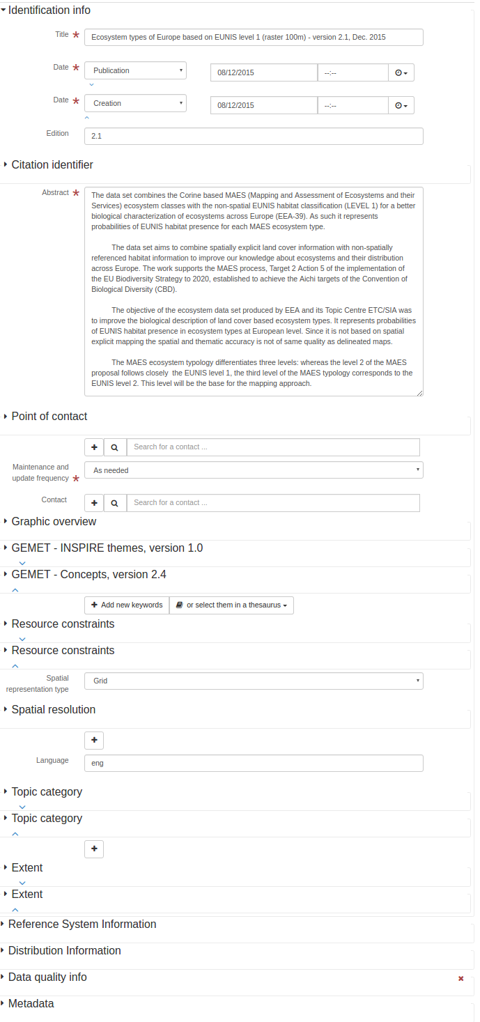
<gco:CharacterString>The data set combines the Corine based MAES (Mapping and Assessment of
Ecosystems and their Services) ecosystem classes with the non-spatial EUNIS habitat
classification (LEVEL 1) for a better biological characterization of ecosystems across
Europe (EEA-39). As such it represents probabilities of EUNIS habitat presence for each
MAES ecosystem type.
The data set aims to combine spatially explicit land cover information with non-spatially
referenced habitat information to improve our knowledge about ecosystems and their
distribution across Europe. The work supports the MAES process, Target 2 Action 5 of the
implementation of the EU Biodiversity Strategy to 2020, established to achieve the Aichi
targets of the Convention of Biological Diversity (CBD).
The objective of the ecosystem data set produced by EEA and its Topic Centre ETC/SIA was
to improve the biological description of land cover based ecosystem types. It represents
probabilities of EUNIS habitat presence in ecosystem types at European level. Since it is
not based on spatial explicit mapping the spatial and thematic accuracy is not of same
quality as delineated maps.
The MAES ecosystem typology differentiates three levels: whereas the level 2 of the MAES
proposal follows closely the EUNIS level 1, the third level of the MAES typology
corresponds to the EUNIS level 2. This level will be the base for the mapping approach.
</gco:CharacterString>
</gmd:abstract>
アクセス制限.
- 名前.名前.
GMD:アクセス制約
- 説明する.
<gmd:accessConstraints xmlns:gmd="http://www.isotc211.org/2005/gmd" xmlns:gml="http://www.opengis.net/gml"
                       xmlns:xlink="http://www.w3.org/1999/xlink">
   <gmd:MD_RestrictionCode codeList="http://standards.iso.org/ittf/PubliclyAvailableStandards/ISO_19139_Schemas/resources/codelist/ML_gmxCodelists.xml#MD_RestrictionCode"
                           codeListValue="otherRestrictions"/>
</gmd:accessConstraints>
住所.住所
- 名前.名前.
GMD:アドレス
- 文脈.
GMD:CI_ResponsibleParty
- 説明する.
住所.住所
- 名前.名前.
GMD:アドレス
- 説明する.
行政区画.
- 名前.名前.
GMD:管理エリア
- 説明する.
集約データセット識別子
- 名前.名前.
GMD:AggregateDataSetIdentifier
- 説明する.
集約データセット名
- 名前.名前.
GMD:AggregateDataSetName
- 説明する.
情報を集約する
- 名前.名前.
GMD:AggregationInfo
- 説明する.
予備見出し.
- 名前.名前.
GMD:AlternateTitle
- 説明する.
番号を修正する
- 名前.名前.
GMD:改訂号
- 説明する.
アプリケーション構成ファイル
- 名前.名前.
GMD:アプリケーションプロファイル
- 説明する.
アプリケーションアーキテクチャ情報
- 名前.名前.
GMD:ApplationSchemaInfo
- 説明する.
関連タイプ
- 名前.名前.
GMD:関連タイプ
- 説明する.
- 条件.条件
強制的である.
属性記述
- 名前.名前.
GMD:属性記述
- 説明する.
- 条件.条件
強制的である.
属性例
- 名前.名前.
GMD:属性インスタンス
- 説明する.
属性
- 名前.名前.
GMD:プロパティ
- 説明する.
軸サイズ属性
- 名前.名前.
GMD:axisDimensionProperties
- 説明する.
各値の桁
- 名前.名前.
GMD:bitsPerValue
- 説明する.
カメラ校正情報可用性
- 名前.名前.
GMD:カメラ校正情報可用性
- 説明する.
ボクセルジオメトリ
- 名前.名前.
GMD:細胞幾何学
- 説明する.
- 条件.条件
強制的である.
中心点.
- 名前.名前.
GMD:中心点
- 説明する.
文字コード
- 名前.名前.
GMD:文字コード
- 説明する.
文字集.
- 名前.名前.
GMD:文字セット
- 文脈.
GMD:MD_METADATA
- 説明する.
- 条件.条件
条件性.
<gmd:characterSet xmlns:gmd="http://www.isotc211.org/2005/gmd" xmlns:gml="http://www.opengis.net/gml"
                  xmlns:xlink="http://www.w3.org/1999/xlink">
   <gmd:MD_CharacterSetCode codeList="http://standards.iso.org/ittf/PubliclyAvailableStandards/ISO_19139_Schemas/resources/codelist/ML_gmxCodelists.xml#MD_CharacterSetCode"
                            codeListValue="utf8"/>
</gmd:characterSet>
文字集.
- 名前.名前.
GMD:文字セット
- 文脈.
GMD:MD_データ識別子
- 説明する.
<gmd:characterSet xmlns:gmd="http://www.isotc211.org/2005/gmd" xmlns:gml="http://www.opengis.net/gml"
                  xmlns:xlink="http://www.w3.org/1999/xlink">
   <gmd:MD_CharacterSetCode codeList="http://standards.iso.org/ittf/PubliclyAvailableStandards/ISO_19139_Schemas/resources/codelist/ML_gmxCodelists.xml#MD_CharacterSetCode"
                            codeListValue="utf8"/>
</gmd:characterSet>
文字集.
- 名前.名前.
GMD:文字セット
- 説明する.
- 条件.条件
条件性.
<gmd:characterSet xmlns:gmd="http://www.isotc211.org/2005/gmd" xmlns:gml="http://www.opengis.net/gml"
                  xmlns:xlink="http://www.w3.org/1999/xlink">
   <gmd:MD_CharacterSetCode codeList="http://standards.iso.org/ittf/PubliclyAvailableStandards/ISO_19139_Schemas/resources/codelist/ML_gmxCodelists.xml#MD_CharacterSetCode"
                            codeListValue="utf8"/>
</gmd:characterSet>
チェックポイント可用性
- 名前.名前.
GMD:チェックポイント可用性
- 説明する.
- 条件.条件
強制的である.
チェックポイント記述
- 名前.名前.
GMD:チェックポイント記述
- 説明する.
- 条件.条件
条件性.
住所.住所
- 名前.名前.
GMD:CI_ADDRESS
- 説明する.
引証.
- 名前.名前.
GMD:CI_引用文
- 説明する.
連絡先
- 名前.名前.
GMD:CI_CONTACT
- 説明する.
日取り
- 名前.名前.
GMD:CI_DATE
- 説明する.
日付タイプコード
- 名前.名前.
GMD:CI_DateTypeCode
- 説明する.
標準コードリスト日付タイプコード(GMD:CI_DateTypeCode)
エンコード |
ラベル |
説明する. |
|---|---|---|
創作 |
創作 |
日付識別リソースの有効時間 |
出版する. |
出版する. |
日付表示リソースが発行された時間 |
改訂する. |
改訂版. |
日付識別情報のチェックまたは再チェック、リソースの改善、または修正の時間 |
オンライン機能コード
- 名前.名前.
GMD:CI_OnLineFunctionCode
- 説明する.
標準コードリストオンライン機能コード(GMD:CI_OnLineFunctionCode)
エンコード |
ラベル |
説明する. |
|---|---|---|
ダウンロード |
ダウンロード |
1つの記憶装置またはシステムから別の記憶装置またはシステムにデータを送信するオンライン説明 |
情報 |
情報 |
資源に関するオンライン情報 |
オフラインアクセス. |
オフラインアクセス. |
プログラムへの資源要求に関するオンライン説明 |
注文書 |
注文書 |
資源を取得するオンライン注文プロセス |
捜索 |
検索して |
リソースに関する情報を検索するためのオンライン検索インタフェース |
オンライン資源.
- 名前.名前.
GMD:CI_OnlineResource
- 説明する.
ヴィジーズコード(PresentatieWijze Code)を提示します
- 名前.名前.
GMD:CI_PresentationFormCode
- 説明する.
標準コードリストPresentatieWijzeコード(GMD:CI_PresentationFormCode)
エンコード |
ラベル |
説明する. |
|---|---|---|
文書数字. |
デジタル文書. |
主なテキスト項目の数字表示(イラストも含むことも可能) |
画像数字 |
デジタル画像. |
視覚または電磁スペクトルの任意の他の部分を熱赤外および高解像度レーダのようなセンサによって感知することによって得られる自然または人工的な特徴、物体および活動の類似性は、デジタルフォーマットで格納される。 |
文書ハードコピー |
ハードコピーファイル |
主なテキスト項目は、紙、写真材料、または他の媒体に表示される(イラストを含むこともできる |
映像ハードコピー |
ハードコピー画像 |
視覚または電磁スペクトルの任意の他の部分をセンサ(例えば、熱赤外および高解像度レーダー)によって感知することによって得られた自然または人工特徴、物体および活動の類似性は、紙、写真材料または他の媒体に複製され、人間が直接使用するために使用される。 |
MapDigital地図 |
デジタル地図. |
グリッドやベクトルで表現された地図 |
地図ハードコピー |
ハードコピー地図 |
紙や写真材料や他のメディアに印刷されて人間のユーザが直接使用するための地図 |
Model Digital |
デジタルモデル. |
特徴,過程などの多次元数字表示. |
モデルハードコピー |
ハードコピーモデル |
3次元物理モデル |
プロファイル数字 |
デジタル構成ファイル |
デジタル形式の垂直横断面 |
構成ファイルのハードコピー |
ハードコピープロファイル |
紙に印刷された垂直断面等。 |
表の数字 |
デジタル作業台 |
システムが表示する事実や数字の数字は,特に欄で表示されることを指す |
表硬コピー |
ハードコピー表 |
体系的に示された事実または数字は、特に欄、印刷物、撮影材料、または他の媒体の形態を意味する |
ビデオ数字 |
デジタルビデオ. |
デジタルビデオ. |
ビデオハードコピー |
ハードコピービデオ |
フィルムのビデオ |
責任者.
- 名前.名前.
GMD:CI_ResponsibleParty
- 説明する.
キャラクターコード
- 名前.名前.
GMD:CI_RoleCode
- 説明する.
標準コードリストロールコード(GMD:CI_RoleCode)
エンコード |
ラベル |
説明する. |
|---|---|---|
資源提供者 |
資源提供者 |
資源を提供する側 |
保管人. |
保管人. |
データに対する責任と責任を受け、資源の適切な看護とメンテナンスを行う側を確保する |
所有者. |
所有者. |
資源を持つ側 |
ユーザー.ユーザー |
ユーザー.ユーザー |
資源を使う側 |
分配器. |
総代理店 |
資源を分配する側 |
発起人. |
発起人. |
資源を作る参加者は |
Point OfContact |
接触点. |
資源に関する知識や資源を獲得する側に連絡することができる |
首席調査員 |
首席調査員 |
情報収集と研究を担当するキーパーソン |
プロセッサ |
処理機. |
Wha側でデータを処理する方法は、リソースが修正されている |
出版者. |
出版者. |
資源を発表する側は |
作者 |
作者 |
資源の著者 |
シリーズ
- 名前.名前.
GMD:CI_シリーズ
- 説明する.
電話だよ
- 名前.名前.
GMD:CI_電話
- 説明する.
引証.
- 名前.名前.
GMD:引用文
- 文脈.
GMD:MD_IDENTIFICATION
- 説明する.
<gmd:citation xmlns:gmd="http://www.isotc211.org/2005/gmd" xmlns:gml="http://www.opengis.net/gml"
              xmlns:xlink="http://www.w3.org/1999/xlink">
   <gmd:CI_Citation>
      <gmd:title>
         <gco:CharacterString>Ecosystem types of Europe based on EUNIS level 1 (raster 100m) -
              version 2.1, Dec. 2015
            </gco:CharacterString>
      </gmd:title>
      <gmd:date>
         <gmd:CI_Date>
            <gmd:date>
               <gco:Date>2015-12-08</gco:Date>
            </gmd:date>
            <gmd:dateType>
               <gmd:CI_DateTypeCode codeList="http://standards.iso.org/ittf/PubliclyAvailableStandards/ISO_19139_Schemas/resources/codelist/ML_gmxCodelists.xml#CI_DateTypeCode"
                                    codeListValue="publication"/>
            </gmd:dateType>
         </gmd:CI_Date>
      </gmd:date>
      <gmd:date>
         <gmd:CI_Date>
            <gmd:date>
               <gco:Date>2015-12-08</gco:Date>
            </gmd:date>
            <gmd:dateType>
               <gmd:CI_DateTypeCode codeList="http://standards.iso.org/ittf/PubliclyAvailableStandards/ISO_19139_Schemas/resources/codelist/ML_gmxCodelists.xml#CI_DateTypeCode"
                                    codeListValue="creation"/>
            </gmd:dateType>
         </gmd:CI_Date>
      </gmd:date>
      <gmd:edition>
         <gco:CharacterString>2.1</gco:CharacterString>
      </gmd:edition>
      <gmd:identifier>
         <gmd:RS_Identifier>
            <gmd:code>
               <gco:CharacterString>eea_r_3035_100_m_ecosystem-types-l1_2006_rev2-1
                </gco:CharacterString>
            </gmd:code>
         </gmd:RS_Identifier>
      </gmd:identifier>
   </gmd:CI_Citation>
</gmd:citation>
引証.
- 名前.名前.
GMD:引用文
- 文脈.
GMD:MD_トピック辞書
- 説明する.
<gmd:citation xmlns:gmd="http://www.isotc211.org/2005/gmd" xmlns:gml="http://www.opengis.net/gml"
              xmlns:xlink="http://www.w3.org/1999/xlink">
   <gmd:CI_Citation>
      <gmd:title>
         <gco:CharacterString>Ecosystem types of Europe based on EUNIS level 1 (raster 100m) -
              version 2.1, Dec. 2015
            </gco:CharacterString>
      </gmd:title>
      <gmd:date>
         <gmd:CI_Date>
            <gmd:date>
               <gco:Date>2015-12-08</gco:Date>
            </gmd:date>
            <gmd:dateType>
               <gmd:CI_DateTypeCode codeList="http://standards.iso.org/ittf/PubliclyAvailableStandards/ISO_19139_Schemas/resources/codelist/ML_gmxCodelists.xml#CI_DateTypeCode"
                                    codeListValue="publication"/>
            </gmd:dateType>
         </gmd:CI_Date>
      </gmd:date>
      <gmd:date>
         <gmd:CI_Date>
            <gmd:date>
               <gco:Date>2015-12-08</gco:Date>
            </gmd:date>
            <gmd:dateType>
               <gmd:CI_DateTypeCode codeList="http://standards.iso.org/ittf/PubliclyAvailableStandards/ISO_19139_Schemas/resources/codelist/ML_gmxCodelists.xml#CI_DateTypeCode"
                                    codeListValue="creation"/>
            </gmd:dateType>
         </gmd:CI_Date>
      </gmd:date>
      <gmd:edition>
         <gco:CharacterString>2.1</gco:CharacterString>
      </gmd:edition>
      <gmd:identifier>
         <gmd:RS_Identifier>
            <gmd:code>
               <gco:CharacterString>eea_r_3035_100_m_ecosystem-types-l1_2006_rev2-1
                </gco:CharacterString>
            </gmd:code>
         </gmd:RS_Identifier>
      </gmd:identifier>
   </gmd:CI_Citation>
</gmd:citation>
引証.
- 名前.名前.
GMD:引用文
- 説明する.
<gmd:citation xmlns:gmd="http://www.isotc211.org/2005/gmd" xmlns:gml="http://www.opengis.net/gml"
              xmlns:xlink="http://www.w3.org/1999/xlink">
   <gmd:CI_Citation>
      <gmd:title>
         <gco:CharacterString>Ecosystem types of Europe based on EUNIS level 1 (raster 100m) -
              version 2.1, Dec. 2015
            </gco:CharacterString>
      </gmd:title>
      <gmd:date>
         <gmd:CI_Date>
            <gmd:date>
               <gco:Date>2015-12-08</gco:Date>
            </gmd:date>
            <gmd:dateType>
               <gmd:CI_DateTypeCode codeList="http://standards.iso.org/ittf/PubliclyAvailableStandards/ISO_19139_Schemas/resources/codelist/ML_gmxCodelists.xml#CI_DateTypeCode"
                                    codeListValue="publication"/>
            </gmd:dateType>
         </gmd:CI_Date>
      </gmd:date>
      <gmd:date>
         <gmd:CI_Date>
            <gmd:date>
               <gco:Date>2015-12-08</gco:Date>
            </gmd:date>
            <gmd:dateType>
               <gmd:CI_DateTypeCode codeList="http://standards.iso.org/ittf/PubliclyAvailableStandards/ISO_19139_Schemas/resources/codelist/ML_gmxCodelists.xml#CI_DateTypeCode"
                                    codeListValue="creation"/>
            </gmd:dateType>
         </gmd:CI_Date>
      </gmd:date>
      <gmd:edition>
         <gco:CharacterString>2.1</gco:CharacterString>
      </gmd:edition>
      <gmd:identifier>
         <gmd:RS_Identifier>
            <gmd:code>
               <gco:CharacterString>eea_r_3035_100_m_ecosystem-types-l1_2006_rev2-1
                </gco:CharacterString>
            </gmd:code>
         </gmd:RS_Identifier>
      </gmd:identifier>
   </gmd:CI_Citation>
</gmd:citation>
被引用責任者
- 名前.名前.
GMD:CitedResponsible Party
- 説明する.
都市.都市
- 名前.名前.
GMD:都市
- 説明する.
分類する.
- 名前.名前.
GMD:分類
- 説明する.
- 条件.条件
強制的である.
分類システム
- 名前.名前.
GMD:分類システム
- 説明する.
雲量被覆率
- 名前.名前.
GMD:クラウドカバー率
- 説明する.
一意のリソース識別子
- 名前.名前.
GMD:コード
- 文脈.
GMD:RS_Identifier
- 説明する.
- 条件.条件
強制的である.
コード
- 名前.名前.
GMD:コード
- 文脈.
GMD:MD_Identifier
- 説明する.
- 条件.条件
強制的である.
コード
- 名前.名前.
GMD:コード
- 文脈.
GMD:MD_CodeValue
- 説明する.
コード空間.
- 名前.名前.
GMD:コード空間
- 説明する.
推薦値.
エンコード |
ラベル |
|---|---|
EPSG |
EPSG |
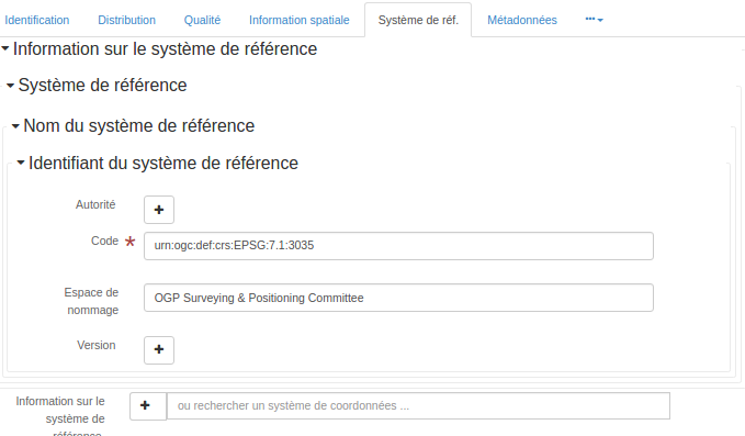
<gmd:codeSpace xmlns:gmd="http://www.isotc211.org/2005/gmd" xmlns:gml="http://www.opengis.net/gml"
xmlns:xlink="http://www.w3.org/1999/xlink">
<gco:CharacterString>OGP Surveying & Positioning Committee</gco:CharacterString>
</gmd:codeSpace>
集団の称号.
- 名前.名前.
GMD:集合体タイトル
- 説明する.
コンプライアンスコード.
- 名前.名前.
GMD:コンプライアンスコード
- 説明する.
ComposedOf
- 名前.名前.
GMD:
- 説明する.
圧縮生成量
- 名前.名前.
GMD:圧縮生成数
- 説明する.
条件.条件
- 名前.名前.
GMD:条件
- 説明する.
制約言語.
- 名前.名前.
GMD:制約言語
- 説明する.
- 条件.条件
強制的である.
連絡先
- 名前.名前.
GMD:連絡先
- 文脈.
GMD:MD_METADATA
- 説明する.
- 条件.条件
強制的である.
<gmd:contact xmlns:gmd="http://www.isotc211.org/2005/gmd" xmlns:gml="http://www.opengis.net/gml"
             xmlns:xlink="http://www.w3.org/1999/xlink">
   <gmd:CI_ResponsibleParty>
      <gmd:organisationName>
         <gco:CharacterString>European Environment Agency</gco:CharacterString>
      </gmd:organisationName>
      <gmd:contactInfo>
         <gmd:CI_Contact>
            <gmd:address>
               <gmd:CI_Address>
                  <gmd:deliveryPoint>
                     <gco:CharacterString>Kongens Nytorv 6</gco:CharacterString>
                  </gmd:deliveryPoint>
                  <gmd:city>
                     <gco:CharacterString>Copenhagen</gco:CharacterString>
                  </gmd:city>
                  <gmd:administrativeArea>
                     <gco:CharacterString>K</gco:CharacterString>
                  </gmd:administrativeArea>
                  <gmd:postalCode>
                     <gco:CharacterString>1050</gco:CharacterString>
                  </gmd:postalCode>
                  <gmd:country>
                     <gco:CharacterString>Denmark</gco:CharacterString>
                  </gmd:country>
                  <gmd:electronicMailAddress>
                     <gco:CharacterString>eea.enquiries@eea.europa.eu</gco:CharacterString>
                  </gmd:electronicMailAddress>
               </gmd:CI_Address>
            </gmd:address>
         </gmd:CI_Contact>
      </gmd:contactInfo>
      <gmd:role>
         <gmd:CI_RoleCode codeList="http://standards.iso.org/ittf/PubliclyAvailableStandards/ISO_19139_Schemas/resources/codelist/ML_gmxCodelists.xml#CI_RoleCode"
                          codeListValue="pointOfContact"/>
      </gmd:role>
   </gmd:CI_ResponsibleParty>
</gmd:contact>
連絡先
- 名前.名前.
GMD:連絡先
- 文脈.
GMD:MD_MaintenanceInformation
- 説明する.
<gmd:contact xmlns:gmd="http://www.isotc211.org/2005/gmd" xmlns:gml="http://www.opengis.net/gml"
             xmlns:xlink="http://www.w3.org/1999/xlink">
   <gmd:CI_ResponsibleParty>
      <gmd:organisationName>
         <gco:CharacterString>European Environment Agency</gco:CharacterString>
      </gmd:organisationName>
      <gmd:contactInfo>
         <gmd:CI_Contact>
            <gmd:address>
               <gmd:CI_Address>
                  <gmd:deliveryPoint>
                     <gco:CharacterString>Kongens Nytorv 6</gco:CharacterString>
                  </gmd:deliveryPoint>
                  <gmd:city>
                     <gco:CharacterString>Copenhagen</gco:CharacterString>
                  </gmd:city>
                  <gmd:administrativeArea>
                     <gco:CharacterString>K</gco:CharacterString>
                  </gmd:administrativeArea>
                  <gmd:postalCode>
                     <gco:CharacterString>1050</gco:CharacterString>
                  </gmd:postalCode>
                  <gmd:country>
                     <gco:CharacterString>Denmark</gco:CharacterString>
                  </gmd:country>
                  <gmd:electronicMailAddress>
                     <gco:CharacterString>eea.enquiries@eea.europa.eu</gco:CharacterString>
                  </gmd:electronicMailAddress>
               </gmd:CI_Address>
            </gmd:address>
         </gmd:CI_Contact>
      </gmd:contactInfo>
      <gmd:role>
         <gmd:CI_RoleCode codeList="http://standards.iso.org/ittf/PubliclyAvailableStandards/ISO_19139_Schemas/resources/codelist/ML_gmxCodelists.xml#CI_RoleCode"
                          codeListValue="pointOfContact"/>
      </gmd:role>
   </gmd:CI_ResponsibleParty>
</gmd:contact>
連絡情報.
- 名前.名前.
Gmd:連絡先情報
- 説明する.
連絡説明.
- 名前.名前.
GMD:ContactInstructions
- 説明する.
内容情報
- 名前.名前.
Gmd:contentInfo
- 説明する.
<gmd:contentInfo xmlns:gmd="http://www.isotc211.org/2005/gmd" xmlns:gml="http://www.opengis.net/gml"
xmlns:xlink="http://www.w3.org/1999/xlink">
<gmd:MD_FeatureCatalogueDescription>
<gmd:includedWithDataset>
<gco:Boolean>false</gco:Boolean>
</gmd:includedWithDataset>
<gmd:featureCatalogueCitation uuidref="e38815ec-a386-45e5-9d1c-b13e0f6ca9e0"
xlink:href="http://sdi.eea.europa.eu/internal-catalogue/srv/eng/csw?service=CSW&request=GetRecordById&version=2.0.2&outputSchema=http://www.isotc211.org/2005/gmd&elementSetName=full&id=e38815ec-a386-45e5-9d1c-b13e0f6ca9e0"/>
</gmd:MD_FeatureCatalogueDescription>
</gmd:contentInfo>
コンテンツタイプ
- 名前.名前.
GMD:Content Type
- 説明する.
- 条件.条件
強制的である.
制御点可用性
- 名前.名前.
GMD:Control PointAvailability
- 説明する.
- 条件.条件
強制的である.
角点.
- 名前.名前.
GMD:角点
- 説明する.
- 条件.条件
強制的である.
国
- 名前.名前.
GMD:国/地域
- 説明する.
国
- 名前.名前.
GMD:国/地域
- 文脈.
GMD:MD_LARPORATION
- 説明する.
国
- 名前.名前.
GMD:国/地域
- 文脈.
PT_Group
- 説明する.
信用.信用
- 名前.名前.
GMD:信用
- 説明する.
データ品質情報
- 名前.名前.
GMD:dataQualityInfo
- 説明する.
<gmd:dataQualityInfo xmlns:gmd="http://www.isotc211.org/2005/gmd" xmlns:gml="http://www.opengis.net/gml"
xmlns:xlink="http://www.w3.org/1999/xlink">
<gmd:DQ_DataQuality>
<gmd:scope>
<gmd:DQ_Scope>
<gmd:level>
<gmd:MD_ScopeCode codeListValue="dataset"
codeList="http://standards.iso.org/ittf/PubliclyAvailableStandards/ISO_19139_Schemas/resources/codelist/ML_gmxCodelists.xml#MD_ScopeCode"/>
</gmd:level>
</gmd:DQ_Scope>
</gmd:scope>
<gmd:lineage>
<gmd:LI_Lineage>
<gmd:statement>
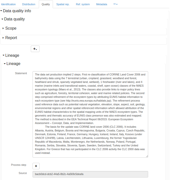
<gco:CharacterString>The data set production implied 2 steps. First re-classification of
CORINE Land Cover 2006 and bathymetry data using the 7 terrestrial (urban, cropland,
grassland, woodland and forest, heathland and shrub, sparsely vegetated land,
wetland), 1 freshwater (river and lakes), and 4 marine (marine inlets and transitional
waters, coastal, shelf, open ocean) classes of the MAES ecosystem typology (Maes et
al., 2013). The classes also provide links to major policy lines such as agriculture,
forestry, territorial cohesion, water and marine related policies. The second step
comprised refinement of the ecosystem types by attributing EUNIS habitat information
to each ecosystem type (see http://eunis.eea.europa.eu/habitats.jsp). The refinement
process used reference data such as potential natural vegetation, elevation, slope,
aspect, soil, geology, environmental regions and other spatial referenced information
which allowed attribution of the EUNIS habitat characteristics to the spatial mapping
units of the MAES ecosystem types. The geometric and thematic accuracy of EUNIS class
presence was also estimated and mapped. The method is described in the EEA Technical
Report 06/2015: European Ecosystem Assessment – Concept, Data, and Implementation.
The basis for the update was CORINE land cover 2006 (CLC 2006). It includes Albania,
Austria, Belgium, Bosnia and Herzegovina, Bulgaria, Croatia, Cyprus, Czech Republic,
Denmark, Estonia, Finland, France, Germany, Hungary, Iceland, Ireland, Italy, Kosovo
(under UNSCR 1244/99), Latvia, Liechtenstein, Lithuania, Luxembourg, the former
Yugoslavian Republic of Macedonia, Malta, Montenegro, the Netherlands, Norway, Poland,
Portugal, Romania, Serbia, Slovakia, Slovenia, Spain, Sweden, Switzerland, Turkey and
the United Kingdom. For Greece that has not participated in the CLC 2006 activity the
CLC 2000 data was used instead.
</gco:CharacterString>
</gmd:statement>
<gmd:source uuidref="bacb0dcd-dcb2-44a5-8b2c-4a569c5deafa"/>
</gmd:LI_Lineage>
</gmd:lineage>
</gmd:DQ_DataQuality>
</gmd:dataQualityInfo>
データ集.
- 名前.名前.
GMD:データセット
- 説明する.
データ集URI
- 名前.名前.
GMD:dataSetURI
- 説明する.
データタイプ
- 名前.名前.
GMD:データタイプ
- 説明する.
- 条件.条件
強制的である.
日取り
- 名前.名前.
GMD:日付
- 説明する.
- 条件.条件
強制的である.
前回の更新日
- 名前.名前.
GMD:日付
- 文脈.
GMD:MD_REVISION
- 説明する.
次の更新の日
- 名前.名前.
GMD:日付
- 文脈.
GMD:MD_MaintenanceInformation
- 説明する.
日取り
- 名前.名前.
GMD:日付
- 文脈.
GMD:CI_引用文
- 説明する.
- 条件.条件
強制的である.
日取り
- 名前.名前.
GMD:日付
- 文脈.
GMD:CI_DATE
- 説明する.
- 条件.条件
強制的である.
次の更新の日
- 名前.名前.
GMD:dateOfNextUpdate
- 説明する.
日付スタンプ.
- 名前.名前.
GMD:消印
- 説明する.
- 条件.条件
強制的である.
<gmd:dateStamp xmlns:gmd="http://www.isotc211.org/2005/gmd" xmlns:gml="http://www.opengis.net/gml"
               xmlns:xlink="http://www.w3.org/1999/xlink">
   <gco:DateTime>2016-01-15T16:57:35</gco:DateTime>
</gmd:dateStamp>
日付/時間
- 名前.名前.
GMD:日時
- 説明する.
日付/時間
- 名前.名前.
GMD:日時
- 文脈.
LI_ProcessStep
- 説明する.
日付/時間
- 名前.名前.
GMD:日時
- 文脈.
GMD:DQ_ELEMENT
- 説明する.
日付タイプ
- 名前.名前.
GMD:日付タイプ
- 説明する.
- 条件.条件
強制的である.
定義する.
- 名前.名前.
GMD:定義
- 説明する.
- 条件.条件
強制的である.
配達所.
- 名前.名前.
GMD:配達先
- 説明する.
分母.分母
- 名前.名前.
GMD:分母
- 説明する.
- 条件.条件
分母または距離の追加
推薦値.
エンコード |
ラベル |
|---|---|
5000 |
1:5‘000 |
10000 |
1:10‘000 |
25000 |
1:25‘000 |
50000 |
1:50‘000 |
100000 |
1:100‘000 |
200000 |
1:200‘000 |
300000 |
1:300‘000 |
500000 |
1:500‘000 |
1000000 |
1:1‘000’000 |
密度
- 名前.名前.
GMD:密度
- 説明する.
密度単位.
- 名前.名前.
GMD:密度単位
- 説明する.
- 条件.条件
条件性.
説明する.
- 名前.名前.
GMD:記述
- 説明する.
説明する.
- 名前.名前.
GMD:説明
- 説明する.
説明する.
- 名前.名前.
GMD:説明
- 文脈.
Gmd:md_AbstractClass
- 説明する.
説明する.
- 名前.名前.
GMD:説明
- 文脈.
LI_ProcessStep
- 説明する.
- 条件.条件
強制的である.
説明する.
- 名前.名前.
GMD:説明
- 文脈.
LI_Source
- 説明する.
説明する.
- 名前.名前.
GMD:説明
- 文脈.
GMD:EX_EXTEND
- 説明する.
説明する.
- 名前.名前.
GMD:説明
- 文脈.
GMD:CI_OnlineResource
- 説明する.
推薦値.
エンコード |
ラベル |
|---|---|
ETRS 89/LAEAヨーロッパ |
|
Belge 1972/ベルギー人ランバート72 |
|
ETRS 89-XYZ:ETRS 89における三次元デカルト |
|
ETRS 89−GRS 80 h:GRS 80上のETRS 89における3次元大地測定 |
|
ETRS 89−GRS 802 D:GRS 80上のETRS 89における大地測定 |
|
ETRS 89-LAEA 2 D:GRS 80上のETRS 89におけるLAEA投影 |
|
ETRS 89-LCC 2 D:GRS 80上のETRS 89におけるLCC投影 |
|
ETRS 89-TM 26 N 2 D:ETRS 89中のTMはGRS 80に投影され、26 N領域(30°W~24°W) |
|
ETRS 89-TM 27 N 2 D:ETRS 89中のTMはGRS 80に投影され、27 N領域(24°W~18°W) |
|
ETRS 89-TM 28 N:GRS 80上のETRS 89中の2 D TM投影、28 N領域(18°W~12°W) |
|
ETRS 89-TM 29 N:GRS 80上のETRS 89における2 D TM投影,29 N領域(12°W~6°W) |
|
ETRS 89−TM 30 N:GRS 80上のETRS 89における2 D TM投影,30 N領域(6°Wから0°) |
|
ETRS 89-TM 31 N:GRS 80上のETRS 89中の2 D TM投影、31 N領域(0°から6°E) |
|
ETRS 89-TM 32 N:GRS 80上のETRS 89における2 D TM投影,32 N領域(6°Eから12°E) |
|
ETRS 89−TM 33 N:GRS 80上のETRS 89中の二次元TM投影,33 N領域(12°Eから18°E) |
|
ETRS 89−TM 34 N:GRS 80上のETRS 89中の二次元TM投影,34 N領域(18°Eから24°E) |
|
ETRS 89-TM 35 N:GRS 80上のETRS 89における2 D TM投影,35 N領域(24°Eから30°E) |
|
ETRS 89−TM 36 N:GRS 80上のETRS 89中の二次元TM投影,36 N領域(30°Eから36°E) |
|
ETRS 89−TM 37 N:GRS 80上のETRS 89中の二次元TM投影,37 N領域(36°Eから42°E) |
|
ETRS 89−TM 38 N:GRS 80上のETRS 89中の二次元TM投影,38 N領域(42°Eから48°E) |
|
ETRS 89−TM 39 N:GRS 80上のETRS 89における2 D TM投影,39 N領域(48°Eから54°E) |
|
EVRS:EVRSにおける高さ |
|
ETRS 89−GRS 80−EVRS:3次元複合:GRS 80上のETRS 89における2次元大地測定とEVRS高度 |
|
RGF 93/Lambert-93 |
|
WGS 84/UTMエリア20 N |
|
RGFG 95/UTM領域22 N |
|
RGR 92/UTMエリア40 S |
|
RGSPM 06/UTMエリア21 N |
|
RGM 04/UTM領域38 S |
説明する.
- 名前.名前.
GMD:説明
- 文脈.
GMD:MD_CodeDomain
- 説明する.
価値説明.
- 名前.名前.
GMD:説明
- 文脈.
GMD:MD_CodeValue
- 説明する.
説明する.
- 名前.名前.
GMD:説明
- 文脈.
GMD:MD_ATTRIBUTE
- 説明する.
説明する.
- 名前.名前.
GMD:説明
- 文脈.
GMD:MD_ROLE
- 説明する.
記述的キーワード
- 名前.名前.
GMD:キーワードを記述する
- 説明する.
記述子
- 名前.名前.
GMD:記述子
- 説明する.
次元数.
- 名前.名前.
GMD:サイズ
- 説明する.
次元名
- 名前.名前.
GMD:DimsionName
- 説明する.
- 条件.条件
強制的である.
寸法の大きさ
- 名前.名前.
GMD:DimsionSize
- 説明する.
- 条件.条件
強制的である.
距離
- 名前.名前.
GMD:距離
- 説明する.
- 条件.条件
該当する縮尺が記録されていない場合は、距離をご提供ください
推薦値.
エンコード |
ラベル |
|---|---|
0.10 |
10 cm |
0.25 |
25 cm |
0.50 |
50 cm |
1 |
1メートル |
30 |
30メートル |
100 |
100メートル |
<gmd:distance xmlns:gmd="http://www.isotc211.org/2005/gmd" xmlns:gml="http://www.opengis.net/gml"
              xmlns:xlink="http://www.w3.org/1999/xlink">
   <gco:Distance uom="m">100</gco:Distance>
</gmd:distance>
配付形式
- 名前.名前.
GMD:DistributionFormat
- 説明する.
- 条件.条件
強制的である.
<gmd:distributionFormat xmlns:gmd="http://www.isotc211.org/2005/gmd" xmlns:gml="http://www.opengis.net/gml"
                        xmlns:xlink="http://www.w3.org/1999/xlink">
   <gmd:MD_Format>
      <gmd:name>
         <gco:CharacterString>GTiff</gco:CharacterString>
      </gmd:name>
      <gmd:version gco:nilReason="missing">
         <gco:CharacterString/>
      </gmd:version>
   </gmd:MD_Format>
</gmd:distributionFormat>
情報を配る
- 名前.名前.
GMD:情報の配布
- 説明する.
<gmd:distributionInfo xmlns:gmd="http://www.isotc211.org/2005/gmd" xmlns:gml="http://www.opengis.net/gml"
                      xmlns:xlink="http://www.w3.org/1999/xlink">
   <gmd:MD_Distribution>
      <gmd:distributionFormat>
         <gmd:MD_Format>
            <gmd:name>
               <gco:CharacterString>GTiff</gco:CharacterString>
            </gmd:name>
            <gmd:version gco:nilReason="missing">
               <gco:CharacterString/>
            </gmd:version>
         </gmd:MD_Format>
      </gmd:distributionFormat>
      <gmd:transferOptions>
         <gmd:MD_DigitalTransferOptions>
            <gmd:onLine>
               <gmd:CI_OnlineResource>
                  <gmd:linkage>
                     <gmd:URL>
                  http://www.eea.europa.eu/data-and-maps/data/ds_resolveuid/d851e1b7f678468b8f0b1b98930ba3e1
                </gmd:URL>
                  </gmd:linkage>
                  <gmd:protocol>
                     <gco:CharacterString>WWW:LINK-1.0-http--link</gco:CharacterString>
                  </gmd:protocol>
                  <gmd:function>
                     <gmd:CI_OnLineFunctionCode codeList="http://standards.iso.org/ittf/PubliclyAvailableStandards/ISO_19139_Schemas/resources/codelist/ML_gmxCodelists.xml#CI_OnLineFunctionCode"
                                                codeListValue="download"/>
                  </gmd:function>
               </gmd:CI_OnlineResource>
            </gmd:onLine>
         </gmd:MD_DigitalTransferOptions>
      </gmd:transferOptions>
   </gmd:MD_Distribution>
</gmd:distributionInfo>
配送/注文プロセス
- 名前.名前.
GMD:DistributionOrderProcess
- 説明する.
総代理店
- 名前.名前.
GMD:総エージェント
- 説明する.
総代理店連絡先
- 名前.名前.
GMD:DistributorContact
- 説明する.
- 条件.条件
強制的である.
総代理店フォーマット
- 名前.名前.
GMD:流通業者フォーマット
- 説明する.
- 条件.条件
条件性.
総エージェント接続オプション
- 名前.名前.
GMD:配信元転送オプション
- 説明する.
ドメインコード.
- 名前.名前.
GMD:ドメインコード
- 説明する.
有効域.
- 名前.名前.
GMD:有効性ドメイン
- 説明する.
閾値.
- 名前.名前.
GMD:domainValue
- 説明する.
絶対外位置精度
- 名前.名前.
GMD:DQ_AbsoluteExternalPositionalAccuracy
- 説明する.
時間測定の正確性
- 名前.名前.
GMD:DQ_AccuracyOfATimeMeasure
- 説明する.
完全性手数料
- 名前.名前.
GMD:DQ_CompletenessCommission
- 説明する.
完全性省略
- 名前.名前.
GMD:DQ_CompletenessOmission
- 説明する.
概念整合性
- 名前.名前.
GMD:DQ_ConceptualConsistency
- 説明する.
一致性結果
- 名前.名前.
GMD:dq_ConformanceResult
- 説明する.
データ品質
- 名前.名前.
GMD:DQ_DataQuality
- 説明する.
<gmd:DQ_DataQuality xmlns:gmd="http://www.isotc211.org/2005/gmd" xmlns:gml="http://www.opengis.net/gml"
                    xmlns:xlink="http://www.w3.org/1999/xlink">
   <gmd:scope>
      <gmd:DQ_Scope>
         <gmd:level>
            <gmd:MD_ScopeCode codeListValue="dataset"
                              codeList="http://standards.iso.org/ittf/PubliclyAvailableStandards/ISO_19139_Schemas/resources/codelist/ML_gmxCodelists.xml#MD_ScopeCode"/>
         </gmd:level>
      </gmd:DQ_Scope>
   </gmd:scope>
   <gmd:lineage>
      <gmd:LI_Lineage>
         <gmd:statement>
            <gco:CharacterString>The data set production implied 2 steps. First re-classification of
              CORINE Land Cover 2006 and bathymetry data using the 7 terrestrial (urban, cropland,
              grassland, woodland and forest, heathland and shrub, sparsely vegetated land,
              wetland), 1 freshwater (river and lakes), and 4 marine (marine inlets and transitional
              waters, coastal, shelf, open ocean) classes of the MAES ecosystem typology (Maes et
              al., 2013). The classes also provide links to major policy lines such as agriculture,
              forestry, territorial cohesion, water and marine related policies. The second step
              comprised refinement of the ecosystem types by attributing EUNIS habitat information
              to each ecosystem type (see http://eunis.eea.europa.eu/habitats.jsp). The refinement
              process used reference data such as potential natural vegetation, elevation, slope,
              aspect, soil, geology, environmental regions and other spatial referenced information
              which allowed attribution of the EUNIS habitat characteristics to the spatial mapping
              units of the MAES ecosystem types. The geometric and thematic accuracy of EUNIS class
              presence was also estimated and mapped. The method is described in the EEA Technical
              Report 06/2015: European Ecosystem Assessment – Concept, Data, and Implementation.
              The basis for the update was CORINE land cover 2006 (CLC 2006). It includes Albania,
              Austria, Belgium, Bosnia and Herzegovina, Bulgaria, Croatia, Cyprus, Czech Republic,
              Denmark, Estonia, Finland, France, Germany, Hungary, Iceland, Ireland, Italy, Kosovo
              (under UNSCR 1244/99), Latvia, Liechtenstein, Lithuania, Luxembourg, the former
              Yugoslavian Republic of Macedonia, Malta, Montenegro, the Netherlands, Norway, Poland,
              Portugal, Romania, Serbia, Slovakia, Slovenia, Spain, Sweden, Switzerland, Turkey and
              the United Kingdom. For Greece that has not participated in the CLC 2006 activity the
              CLC 2000 data was used instead.
            </gco:CharacterString>
         </gmd:statement>
         <gmd:source uuidref="bacb0dcd-dcb2-44a5-8b2c-4a569c5deafa"/>
      </gmd:LI_Lineage>
   </gmd:lineage>
</gmd:DQ_DataQuality>
ドメイン整合性
- 名前.名前.
GMD:DQ_DomainConsistency
- 説明する.
評価方法タイプコード
- 名前.名前.
GMD:DQ_EvaluationMethodTypeCode
- 説明する.
標準コードリスト評価メソッドタイプコード(GMD:DQ_EvaluationMethodTypeCode)
エンコード |
ラベル |
説明する. |
|---|---|---|
直接内部. |
直接内部. |
データセットの項目の検査に基づいてデータセットの品質を評価する方法であって、必要なすべてのデータが評価されているデータセットの内部データであることを特徴とする方法。 |
直接外部 |
直接外部 |
データセットの項目の検査に基づいてデータセット品質を評価する方法であって、評価されるデータセットの外部の参照データが必要であることを特徴とする方法。 |
間接的に |
間接法. |
外部知識に基づいてデータセットの品質を評価する方法 |
フォーマットの一貫性
- 名前.名前.
GMD:DQ_FormatConsistency
- 説明する.
グリッド化データ測位精度
- 名前.名前.
GMD:dq_GriddedDataPositionalAccuracy
- 説明する.
非量子化属性精度
- 名前.名前.
GMD:DQ_NonQuantitativeAttributeAccuracy
- 説明する.
定量属性精度
- 名前.名前.
GMD:dq_QuantitativeAttributeAccuracy
- 説明する.
数量化結果
- 名前.名前.
GMD:dq_QuantitativeResult
- 説明する.
相対内部位置精度
- 名前.名前.
GMD:dq_RelativeInternalPositionalAccuracy
- 説明する.
範囲.範囲.
- 名前.名前.
GMD:DQ_SCOPE
- 説明する.
<gmd:DQ_Scope xmlns:gmd="http://www.isotc211.org/2005/gmd" xmlns:gml="http://www.opengis.net/gml"
              xmlns:xlink="http://www.w3.org/1999/xlink">
   <gmd:level>
      <gmd:MD_ScopeCode codeListValue="dataset"
                        codeList="http://standards.iso.org/ittf/PubliclyAvailableStandards/ISO_19139_Schemas/resources/codelist/ML_gmxCodelists.xml#MD_ScopeCode"/>
   </gmd:level>
</gmd:DQ_Scope>
時間的整合性
- 名前.名前.
GMD:DQ_TemporalConsistency
- 説明する.
時間効果度
- 名前.名前.
GMD:DQ_一時的有効性
- 説明する.
主題分類正解率
- 名前.名前.
GMD:DQ_ThematicClassficationGender(DQ_トピック分類正解率)
- 説明する.
トポロジー整合性
- 名前.名前.
GMD:DQ_TopologicalConsistency
- 説明する.
DS_Association
- 名前.名前.
GMD:DS_Association
- 説明する.
関連タイプ
- 名前.名前.
GMD:DS_AssociationTypeCode
- 説明する.
標準コード列表関連タイプ(GMD:DS_AssociationTypeCode)
エンコード |
ラベル |
説明する. |
|---|---|---|
交差引用. |
交差引用. |
1つのデータセットから別のデータセットに引用する |
大きな仕事引用 |
大きな作品引用文 |
このデータセットが属する主データセットへの引用 |
部分シームレスデータベース |
シームレスなデータベースの一部 |
コンピュータに保存されている同じ構造化データセットの一部 |
源. |
出所 |
データセットのコンテンツソースのマッピングとグラフ情報の描画 |
立体ペアリング |
ステレオの伴侶 |
1組の画像の一部を、一緒に使用する場合に、3次元画像を提供する |
DS_DataSet
- 名前.名前.
GMD:DS_DataSet
- 説明する.
DS_Initiative
- 名前.名前.
GMD:DS_Initiative
- 説明する.
案タイプ
- 名前.名前.
GMD:DS_InitiativeTypeCode
- 説明する.
標準コードリスト案タイプ(GMD:DS_InitiativeTypeCode)
エンコード |
ラベル |
説明する. |
|---|---|---|
活動する. |
選挙活動. |
一連の組織的で計画的な行動 |
募集する. |
集合 |
特定の目的のために組み立てられたデータセットの累積 |
トレーニングをする. |
トレーニングをする. |
ある機能または1組の機能の具体的な実行 |
実験 |
実験 |
何かが有効かどうかを発見することを目的としています |
調べる |
調べる |
検索やシステム検索 |
使命 |
使命 |
データ収集システムの特定操作 |
センサー.センサー |
センサー |
検出または記録装置または装置 |
運営 |
操作 |
一連の行動の一部としての行動 |
ホーム.ホーム |
ホーム.ホーム |
センサを支持する車両または他の支持台 |
行程を決める. |
過程. |
複数のステップに関することをする方法 |
もくろみ |
もくろみ |
具体的計画活動 |
工事 |
プロジェクト. |
組織的な事業、研究、あるいは発展 |
勉強する |
研究する. |
審査や調査 |
役目 |
役目 |
1点の作品. |
裁判にかける |
裁判にかける |
何かを発見したり証明したりするためのテストの過程 |
DS_OtherAggregate
- 名前.名前.
GMD:DS_OtherAggregate
- 説明する.
DS_Platform
- 名前.名前.
GMD:DS_Platform
- 説明する.
DS_ProductionSeries
- 名前.名前.
GMD:DS_ProductionSeries
- 説明する.
DS_Sensor
- 名前.名前.
GMD:DS_センサ
- 説明する.
DS_Series
- 名前.名前.
GMD:DS_シリーズ
- 説明する.
DS_StereoMate
- 名前.名前.
GMD:DS_StereoMate
- 説明する.
東行.
- 名前.名前.
GMD:東経
- 説明する.
- 条件.条件
強制的である.
<gmd:eastBoundLongitude xmlns:gmd="http://www.isotc211.org/2005/gmd" xmlns:gml="http://www.opengis.net/gml"
                        xmlns:xlink="http://www.w3.org/1999/xlink">
   <gco:Decimal>38.1471</gco:Decimal>
</gmd:eastBoundLongitude>
バージョン
- 名前.名前.
GMD:バージョン
- 説明する.
<gmd:edition xmlns:gmd="http://www.isotc211.org/2005/gmd" xmlns:gml="http://www.opengis.net/gml"
             xmlns:xlink="http://www.w3.org/1999/xlink">
   <gco:CharacterString>2.1</gco:CharacterString>
</gmd:edition>
編集日
- 名前.名前.
GMD:バージョン日付
- 説明する.
電子メールアドレス.
- 名前.名前.
GMD:Eメールアドレス
- 説明する.
環境記述
- 名前.名前.
GMD:環境記述
- 説明する.
等価縮尺.
- 名前.名前.
GMD:等価比
- 説明する.
誤った統計情報
- 名前.名前.
GMD:誤った統計
- 説明する.
評価方法の説明
- 名前.名前.
GMD:評価方法の説明
- 説明する.
評価方法
- 名前.名前.
GMD:評価方法タイプ
- 説明する.
評価プログラム.
- 名前.名前.
GMD:評価プロセス
- 説明する.
境界多角形
- 名前.名前.
GMD:EX_BORKINGING POLYGON
- 説明する.
程度.程度
- 名前.名前.
GMD:EX_EXTEND
- 説明する.
地理境界枠
- 名前.名前.
GMD:EX_地理境界ボックス
- 説明する.
<gmd:EX_GeographicBoundingBox xmlns:gmd="http://www.isotc211.org/2005/gmd" xmlns:gml="http://www.opengis.net/gml"
                              xmlns:xlink="http://www.w3.org/1999/xlink">
   <gmd:westBoundLongitude>
      <gco:Decimal>-33.90432</gco:Decimal>
   </gmd:westBoundLongitude>
   <gmd:eastBoundLongitude>
      <gco:Decimal>38.1471</gco:Decimal>
   </gmd:eastBoundLongitude>
   <gmd:southBoundLatitude>
      <gco:Decimal>26.988714</gco:Decimal>
   </gmd:southBoundLatitude>
   <gmd:northBoundLatitude>
      <gco:Decimal>60.57849</gco:Decimal>
   </gmd:northBoundLatitude>
</gmd:EX_GeographicBoundingBox>
地理的記述
- 名前.名前.
GMD:EX_GeologicDescription
- 説明する.
時空範囲.
- 名前.名前.
GMD:EX_SpatialTemporalExtent
- 説明する.
時間範囲.
- 名前.名前.
GMD:EX_TemporalExtent
- 説明する.
<gmd:EX_TemporalExtent xmlns:gmd="http://www.isotc211.org/2005/gmd" xmlns:gml="http://www.opengis.net/gml"
                       xmlns:xlink="http://www.w3.org/1999/xlink">
   <gmd:extent>
      <gml:TimePeriod gml:id="d28e322a1049886">
         <gml:beginPosition>2006-01-01</gml:beginPosition>
         <gml:endPosition>2006-12-31</gml:endPosition>
      </gml:TimePeriod>
   </gmd:extent>
</gmd:EX_TemporalExtent>
垂直範囲.
- 名前.名前.
GMD:EX_VerticalExtent
- 説明する.
説明する.
- 名前.名前.
GMD:説明
- 説明する.
- 条件.条件
強制的である.
拡張要素情報
- 名前.名前.
GMD:要素情報を拡張する
- 説明する.
オンライン資源を拡張する
- 名前.名前.
GMD:オンラインリソースの拡張
- 説明する.
程度.程度
- 名前.名前.
GMD:範囲
- 文脈.
GMD:MD_データ識別子
- 説明する.
程度.程度
- 名前.名前.
GMD:範囲
- 文脈.
GMD:DQ_SCOPE
- 説明する.
程度.程度
- 名前.名前.
GMD:範囲
- 文脈.
GMD:EX_TemporalExtent
- 説明する.
セグメントタイプコード
- 名前.名前.
GMD:拡張タイプコード
- 説明する.
ファックスを送る
- 名前.名前.
GMD:ファックス
- 説明する.
要素属性
- 名前.名前.
GMD:機能属性
- 説明する.
特集目録引用
- 名前.名前.
GMD:機能ディレクトリ参照
- 説明する.
- 条件.条件
強制的である.
<gmd:featureCatalogueCitation xmlns:gmd="http://www.isotc211.org/2005/gmd" xmlns:gml="http://www.opengis.net/gml"
uuidref="e38815ec-a386-45e5-9d1c-b13e0f6ca9e0"
xlink:href="http://sdi.eea.europa.eu/internal-catalogue/srv/eng/csw?service=CSW&request=GetRecordById&version=2.0.2&outputSchema=http://www.isotc211.org/2005/gmd&elementSetName=full&id=e38815ec-a386-45e5-9d1c-b13e0f6ca9e0"/>
機能例
- 名前.名前.
GMD:機能例
- 説明する.
機能
- 名前.名前.
GMD:機能
- 説明する.
要素タイプ
- 名前.名前.
GMD:機能タイプ
- 説明する.
要素タイプ
- 名前.名前.
GMD:機能タイプ
- 説明する.
費用.費用
- 名前.名前.
GMD:費用
- 説明する.
文書解凍技術
- 名前.名前.
GMD:ファイル解凍技術
- 説明する.
書類記述.
- 名前.名前.
Gmd:fileDescription
- 説明する.
ファイル識別子
- 名前.名前.
GMD:fileIdentifier
- 説明する.
<gmd:fileIdentifier xmlns:gmd="http://www.isotc211.org/2005/gmd" xmlns:gml="http://www.opengis.net/gml"
                    xmlns:xlink="http://www.w3.org/1999/xlink">
   <gco:CharacterString>e8a366b7-0029-44d7-ae33-7578253179c0</gco:CharacterString>
</gmd:fileIdentifier>
書類名.
- 名前.名前.
GMD:ファイル名
- 説明する.
- 条件.条件
強制的である.
<gmd:fileName xmlns:gmd="http://www.isotc211.org/2005/gmd" xmlns:gml="http://www.opengis.net/gml"
              xmlns:xlink="http://www.w3.org/1999/xlink">
   <gco:CharacterString>
              http://sdi.eea.europa.eu/public/catalogue-graphic-overview/e8a366b7-0029-44d7-ae33-7578253179c0.png
            </gco:CharacterString>
</gmd:fileName>
ファイルタイプ
- 名前.名前.
GMD:ファイルタイプ
- 説明する.
フィルム歪み情報可用性
- 名前.名前.
GMD:映画の変形情報可用性
- 説明する.
フォーマット配信サーバ
- 名前.名前.
GMD:フォーマット配信サーバ
- 説明する.
機能
- 名前.名前.
GMD:機能
- 説明する.
地理的要素
- 名前.名前.
GMD:地理的要素
- 説明する.
<gmd:geographicElement xmlns:gmd="http://www.isotc211.org/2005/gmd" xmlns:gml="http://www.opengis.net/gml"
                       xmlns:xlink="http://www.w3.org/1999/xlink">
   <gmd:EX_GeographicBoundingBox>
      <gmd:westBoundLongitude>
         <gco:Decimal>-33.90432</gco:Decimal>
      </gmd:westBoundLongitude>
      <gmd:eastBoundLongitude>
         <gco:Decimal>38.1471</gco:Decimal>
      </gmd:eastBoundLongitude>
      <gmd:southBoundLatitude>
         <gco:Decimal>26.988714</gco:Decimal>
      </gmd:southBoundLatitude>
      <gmd:northBoundLatitude>
         <gco:Decimal>60.57849</gco:Decimal>
      </gmd:northBoundLatitude>
   </gmd:EX_GeographicBoundingBox>
</gmd:geographicElement>
地理的識別子
- 名前.名前.
GMD:地理的識別子
- 説明する.
- 条件.条件
強制的である.
幾何オブジェクトカウント
- 名前.名前.
GMD:GeometricObjectCount
- 説明する.
幾何学的対象
- 名前.名前.
GMD:幾何学的オブジェクト
- 説明する.
幾何オブジェクトタイプ
- 名前.名前.
GMD:GeometricObjectType
- 説明する.
- 条件.条件
強制的である.
GeoreferencedParameters
- 名前.名前.
GMD:地理的参照パラメータ
- 説明する.
図形の概要
- 名前.名前.
GMD:図面の概要
- 説明する.
<gmd:graphicOverview xmlns:gmd="http://www.isotc211.org/2005/gmd" xmlns:gml="http://www.opengis.net/gml"
                     xmlns:xlink="http://www.w3.org/1999/xlink">
   <gmd:MD_BrowseGraphic>
      <gmd:fileName>
         <gco:CharacterString>
              http://sdi.eea.europa.eu/public/catalogue-graphic-overview/e8a366b7-0029-44d7-ae33-7578253179c0.png
            </gco:CharacterString>
      </gmd:fileName>
   </gmd:MD_BrowseGraphic>
</gmd:graphicOverview>
図形ファイル.
- 名前.名前.
GMD:グラフィックスファイル
- 説明する.
処理説明.
- 名前.名前.
Gmd:handingDescription
- 説明する.
Vbl.はい、あります
- 名前.名前.
GMD:HAS
- 説明する.
階層構造レベル
- 名前.名前.
GMD:HierarchyLevel
- 説明する.
<gmd:hierarchyLevel xmlns:gmd="http://www.isotc211.org/2005/gmd" xmlns:gml="http://www.opengis.net/gml"
                    xmlns:xlink="http://www.w3.org/1999/xlink">
   <gmd:MD_ScopeCode codeList="http://standards.iso.org/ittf/PubliclyAvailableStandards/ISO_19139_Schemas/resources/codelist/ML_gmxCodelists.xml#MD_ScopeCode"
                     codeListValue="dataset"/>
</gmd:hierarchyLevel>
階層構造レベル名
- 名前.名前.
GMD:HierarchyLevelName
- 説明する.
サービス時間
- 名前.名前.
GMD:HoursOfService
- 説明する.
識別情報.
- 名前.名前.
GMD:識別情報
- 説明する.
- 条件.条件
強制的である.
<gmd:identificationInfo xmlns:gmd="http://www.isotc211.org/2005/gmd" xmlns:gml="http://www.opengis.net/gml"
xmlns:xlink="http://www.w3.org/1999/xlink">
<gmd:MD_DataIdentification>
<gmd:citation>
<gmd:CI_Citation>
<gmd:title>
<gco:CharacterString>Ecosystem types of Europe based on EUNIS level 1 (raster 100m) -
version 2.1, Dec. 2015
</gco:CharacterString>
</gmd:title>
<gmd:date>
<gmd:CI_Date>
<gmd:date>
<gco:Date>2015-12-08</gco:Date>
</gmd:date>
<gmd:dateType>
<gmd:CI_DateTypeCode codeList="http://standards.iso.org/ittf/PubliclyAvailableStandards/ISO_19139_Schemas/resources/codelist/ML_gmxCodelists.xml#CI_DateTypeCode"
codeListValue="publication"/>
</gmd:dateType>
</gmd:CI_Date>
</gmd:date>
<gmd:date>
<gmd:CI_Date>
<gmd:date>
<gco:Date>2015-12-08</gco:Date>
</gmd:date>
<gmd:dateType>
<gmd:CI_DateTypeCode codeList="http://standards.iso.org/ittf/PubliclyAvailableStandards/ISO_19139_Schemas/resources/codelist/ML_gmxCodelists.xml#CI_DateTypeCode"
codeListValue="creation"/>
</gmd:dateType>
</gmd:CI_Date>
</gmd:date>
<gmd:edition>
<gco:CharacterString>2.1</gco:CharacterString>
</gmd:edition>
<gmd:identifier>
<gmd:RS_Identifier>
<gmd:code>
<gco:CharacterString>eea_r_3035_100_m_ecosystem-types-l1_2006_rev2-1
</gco:CharacterString>
</gmd:code>
</gmd:RS_Identifier>
</gmd:identifier>
</gmd:CI_Citation>
</gmd:citation>
<gmd:abstract>
<gco:CharacterString>The data set combines the Corine based MAES (Mapping and Assessment of
Ecosystems and their Services) ecosystem classes with the non-spatial EUNIS habitat
classification (LEVEL 1) for a better biological characterization of ecosystems across
Europe (EEA-39). As such it represents probabilities of EUNIS habitat presence for each
MAES ecosystem type.
The data set aims to combine spatially explicit land cover information with non-spatially
referenced habitat information to improve our knowledge about ecosystems and their
distribution across Europe. The work supports the MAES process, Target 2 Action 5 of the
implementation of the EU Biodiversity Strategy to 2020, established to achieve the Aichi
targets of the Convention of Biological Diversity (CBD).
The objective of the ecosystem data set produced by EEA and its Topic Centre ETC/SIA was
to improve the biological description of land cover based ecosystem types. It represents
probabilities of EUNIS habitat presence in ecosystem types at European level. Since it is
not based on spatial explicit mapping the spatial and thematic accuracy is not of same
quality as delineated maps.
The MAES ecosystem typology differentiates three levels: whereas the level 2 of the MAES
proposal follows closely the EUNIS level 1, the third level of the MAES typology
corresponds to the EUNIS level 2. This level will be the base for the mapping approach.
</gco:CharacterString>
</gmd:abstract>
<gmd:pointOfContact>
<gmd:CI_ResponsibleParty>
<gmd:organisationName>
<gco:CharacterString>European Environment Agency</gco:CharacterString>
</gmd:organisationName>
<gmd:contactInfo>
<gmd:CI_Contact>
<gmd:address>
<gmd:CI_Address>
<gmd:deliveryPoint>
<gco:CharacterString>Kongens Nytorv 6</gco:CharacterString>
</gmd:deliveryPoint>
<gmd:city>
<gco:CharacterString>Copenhagen</gco:CharacterString>
</gmd:city>
<gmd:administrativeArea>
<gco:CharacterString>K</gco:CharacterString>
</gmd:administrativeArea>
<gmd:postalCode>
<gco:CharacterString>1050</gco:CharacterString>
</gmd:postalCode>
<gmd:country>
<gco:CharacterString>Denmark</gco:CharacterString>
</gmd:country>
<gmd:electronicMailAddress>
<gco:CharacterString>eea.enquiries@eea.europa.eu</gco:CharacterString>
</gmd:electronicMailAddress>
</gmd:CI_Address>
</gmd:address>
<gmd:onlineResource>
<gmd:CI_OnlineResource>
<gmd:linkage>
<gmd:URL>http://www.eea.europa.eu</gmd:URL>
</gmd:linkage>
<gmd:protocol>
<gco:CharacterString>WWW:LINK-1.0-http--link</gco:CharacterString>
</gmd:protocol>
<gmd:name>
<gco:CharacterString>Europen Environment Agency public website
</gco:CharacterString>
</gmd:name>
<gmd:function>
<gmd:CI_OnLineFunctionCode codeList="http://standards.iso.org/ittf/PubliclyAvailableStandards/ISO_19139_Schemas/resources/codelist/ML_gmxCodelists.xml#CI_OnLineFunctionCode"
codeListValue="information"/>
</gmd:function>
</gmd:CI_OnlineResource>
</gmd:onlineResource>
</gmd:CI_Contact>
</gmd:contactInfo>
<gmd:role>
<gmd:CI_RoleCode codeList="http://standards.iso.org/ittf/PubliclyAvailableStandards/ISO_19139_Schemas/resources/codelist/ML_gmxCodelists.xml#CI_RoleCode"
codeListValue="pointOfContact"/>
</gmd:role>
</gmd:CI_ResponsibleParty>
</gmd:pointOfContact>
<gmd:resourceMaintenance>
<gmd:MD_MaintenanceInformation>
<gmd:maintenanceAndUpdateFrequency>
<gmd:MD_MaintenanceFrequencyCode codeList="http://standards.iso.org/ittf/PubliclyAvailableStandards/ISO_19139_Schemas/resources/codelist/ML_gmxCodelists.xml#MD_MaintenanceFrequencyCode"
codeListValue="asNeeded"/>
</gmd:maintenanceAndUpdateFrequency>
</gmd:MD_MaintenanceInformation>
</gmd:resourceMaintenance>
<gmd:graphicOverview>
<gmd:MD_BrowseGraphic>
<gmd:fileName>
<gco:CharacterString>
http://sdi.eea.europa.eu/public/catalogue-graphic-overview/e8a366b7-0029-44d7-ae33-7578253179c0.png
</gco:CharacterString>
</gmd:fileName>
</gmd:MD_BrowseGraphic>
</gmd:graphicOverview>
<gmd:descriptiveKeywords>
<gmd:MD_Keywords>
<gmd:keyword>
<gco:CharacterString>Land cover</gco:CharacterString>
</gmd:keyword>
<gmd:keyword>
<gco:CharacterString>Habitats and biotopes</gco:CharacterString>
</gmd:keyword>
<gmd:type>
<gmd:MD_KeywordTypeCode codeList="http://www.isotc211.org/2005/resources/codeList.xml#MD_KeywordTypeCode"
codeListValue="theme"/>
</gmd:type>
<gmd:thesaurusName>
<gmd:CI_Citation>
<gmd:title>
<gco:CharacterString>GEMET - INSPIRE themes, version 1.0</gco:CharacterString>
</gmd:title>
<gmd:date>
<gmd:CI_Date>
<gmd:date>
<gco:Date>2008-06-01</gco:Date>
</gmd:date>
<gmd:dateType>
<gmd:CI_DateTypeCode codeList="http://standards.iso.org/ittf/PubliclyAvailableStandards/ISO_19139_Schemas/resources/codelist/ML_gmxCodelists.xml#CI_DateTypeCode"
codeListValue="publication"/>
</gmd:dateType>
</gmd:CI_Date>
</gmd:date>
<gmd:identifier>
<gmd:MD_Identifier>
<gmd:code>
<gmx:Anchor xmlns:gmx="http://www.isotc211.org/2005/gmx"
xlink:href="http://sdi.eea.europa.eu/internal-catalogue/srv/eng/thesaurus.download?ref=external.theme.httpinspireeceuropaeutheme-theme">
geonetwork.thesaurus.external.theme.httpinspireeceuropaeutheme-theme
</gmx:Anchor>
</gmd:code>
</gmd:MD_Identifier>
</gmd:identifier>
</gmd:CI_Citation>
</gmd:thesaurusName>
</gmd:MD_Keywords>
</gmd:descriptiveKeywords>
<gmd:descriptiveKeywords>
<gmd:MD_Keywords>
<gmd:keyword>
<gco:CharacterString>ecosystem</gco:CharacterString>
</gmd:keyword>
<gmd:keyword>
<gco:CharacterString>ecosystem type</gco:CharacterString>
</gmd:keyword>
<gmd:keyword>
<gco:CharacterString>land cover</gco:CharacterString>
</gmd:keyword>
<gmd:keyword>
<gco:CharacterString>environmental assessment</gco:CharacterString>
</gmd:keyword>
<gmd:keyword>
<gco:CharacterString>habitat</gco:CharacterString>
</gmd:keyword>
<gmd:type>
<gmd:MD_KeywordTypeCode codeList="http://www.isotc211.org/2005/resources/codeList.xml#MD_KeywordTypeCode"
codeListValue="theme"/>
</gmd:type>
<gmd:thesaurusName>
<gmd:CI_Citation>
<gmd:title>
<gco:CharacterString>GEMET - Concepts, version 2.4</gco:CharacterString>
</gmd:title>
<gmd:date>
<gmd:CI_Date>
<gmd:date>
<gco:Date>2010-01-13</gco:Date>
</gmd:date>
<gmd:dateType>
<gmd:CI_DateTypeCode codeList="http://standards.iso.org/ittf/PubliclyAvailableStandards/ISO_19139_Schemas/resources/codelist/ML_gmxCodelists.xml#CI_DateTypeCode"
codeListValue="publication"/>
</gmd:dateType>
</gmd:CI_Date>
</gmd:date>
<gmd:identifier>
<gmd:MD_Identifier>
<gmd:code>
<gmx:Anchor xmlns:gmx="http://www.isotc211.org/2005/gmx"
xlink:href="http://sdi.eea.europa.eu/internal-catalogue/srv/eng/thesaurus.download?ref=external.theme.gemet">
geonetwork.thesaurus.external.theme.gemet
</gmx:Anchor>
</gmd:code>
</gmd:MD_Identifier>
</gmd:identifier>
</gmd:CI_Citation>
</gmd:thesaurusName>
</gmd:MD_Keywords>
</gmd:descriptiveKeywords>
<gmd:resourceConstraints>
<gmd:MD_Constraints>
<gmd:useLimitation>
<gco:CharacterString>Unless otherwise indicated, re-use of content on the EEA website
for commercial or non-commercial purposes is permitted free of charge, provided that
the source is acknowledged. The EEA re-use policy follows Directive 2003/98/EC of the
European Parliament and the Council on the re-use of public sector information
throughout the European Union and Commission Decision 2006/291/EC, Euratom on the
re-use of Commission information. The EEA accepts no responsibility or liability
whatsoever for the re-use of content accessible on its website. Any inquiries about
re-use of content on the EEA website should be addressed to Ove Caspersen, EEA,
Kongens Nytorv 6, DK-1050 Copenhagen K, Tel +45 33 36 71 00, Fax +45 33 36 71 99,
e-mail copyrights at eea.europa.eu
</gco:CharacterString>
</gmd:useLimitation>
</gmd:MD_Constraints>
</gmd:resourceConstraints>
<gmd:resourceConstraints>
<gmd:MD_LegalConstraints>
<gmd:accessConstraints>
<gmd:MD_RestrictionCode codeList="http://standards.iso.org/ittf/PubliclyAvailableStandards/ISO_19139_Schemas/resources/codelist/ML_gmxCodelists.xml#MD_RestrictionCode"
codeListValue="otherRestrictions"/>
</gmd:accessConstraints>
<gmd:otherConstraints>
<gco:CharacterString>no limitations</gco:CharacterString>
</gmd:otherConstraints>
</gmd:MD_LegalConstraints>
</gmd:resourceConstraints>
<gmd:spatialRepresentationType>
<gmd:MD_SpatialRepresentationTypeCode codeList="http://standards.iso.org/ittf/PubliclyAvailableStandards/ISO_19139_Schemas/resources/codelist/ML_gmxCodelists.xml#MD_SpatialRepresentationTypeCode"
codeListValue="grid"/>
</gmd:spatialRepresentationType>
<gmd:spatialResolution>
<gmd:MD_Resolution>
<gmd:distance>
<gco:Distance uom="m">100</gco:Distance>
</gmd:distance>
</gmd:MD_Resolution>
</gmd:spatialResolution>
<gmd:language>
<gmd:LanguageCode codeList="http://www.loc.gov/standards/iso639-2/" codeListValue="eng"/>
</gmd:language>
<gmd:topicCategory>
<gmd:MD_TopicCategoryCode>biota</gmd:MD_TopicCategoryCode>
</gmd:topicCategory>
<gmd:topicCategory>
<gmd:MD_TopicCategoryCode>environment</gmd:MD_TopicCategoryCode>
</gmd:topicCategory>
<gmd:extent>
<gmd:EX_Extent>
<gmd:geographicElement>
<gmd:EX_GeographicBoundingBox>
<gmd:westBoundLongitude>
<gco:Decimal>-33.90432</gco:Decimal>
</gmd:westBoundLongitude>
<gmd:eastBoundLongitude>
<gco:Decimal>38.1471</gco:Decimal>
</gmd:eastBoundLongitude>
<gmd:southBoundLatitude>
<gco:Decimal>26.988714</gco:Decimal>
</gmd:southBoundLatitude>
<gmd:northBoundLatitude>
<gco:Decimal>60.57849</gco:Decimal>
</gmd:northBoundLatitude>
</gmd:EX_GeographicBoundingBox>
</gmd:geographicElement>
</gmd:EX_Extent>
</gmd:extent>
<gmd:extent>
<gmd:EX_Extent>
<gmd:temporalElement>
<gmd:EX_TemporalExtent>
<gmd:extent>
<gml:TimePeriod gml:id="d28e322a1049886">
<gml:beginPosition>2006-01-01</gml:beginPosition>
<gml:endPosition>2006-12-31</gml:endPosition>
</gml:TimePeriod>
</gmd:extent>
</gmd:EX_TemporalExtent>
</gmd:temporalElement>
</gmd:EX_Extent>
</gmd:extent>
</gmd:MD_DataIdentification>
</gmd:identificationInfo>
識別子
- 名前.名前.
GMD:識別子
- 説明する.
引用文識別子
- 名前.名前.
GMD:識別子
- 文脈.
GMD:CI_引用文
- 説明する.
照明方位角
- 名前.名前.
GMD:照明方位角
- 説明する.
照明仰角
- 名前.名前.
GMD:照明高度角度
- 説明する.
画像品質コード
- 名前.名前.
GMD:ImageQualityCode
- 説明する.
撮像条件.
- 名前.名前.
GMD:イメージング条件
- 説明する.
データ集に含まれています
- 名前.名前.
GMD:IncluddedWithDataset
- 説明する.
- 条件.条件
強制的である.
<gmd:includedWithDataset xmlns:gmd="http://www.isotc211.org/2005/gmd" xmlns:gml="http://www.opengis.net/gml"
                         xmlns:xlink="http://www.w3.org/1999/xlink">
   <gco:Boolean>false</gco:Boolean>
</gmd:includedWithDataset>
個人名.
- 名前.名前.
GMD:個人名
- 説明する.
案タイプ
- 名前.名前.
GMD:InitiativeType
- 説明する.
ISBN
- 名前.名前.
GMD:ISBN
- 説明する.
ISSN
- 名前.名前.
GMD:ISSN
- 説明する.
問題認識
- 名前.名前.
GMD:問題タグ
- 説明する.
キーワード
- 名前.名前.
GMD:キーワード
- 説明する.
メタデータ言語
- 名前.名前.
GMD:言語
- 説明する.
- 条件.条件
条件性.
言語
- 名前.名前.
GMD:言語
- 文脈.
GMD:MD_データ識別子
- 説明する.
言語
- 名前.名前.
GMD:言語
- 文脈.
GMD:MD_FeatureCatalogueDescription
- 説明する.
言語
- 名前.名前.
GMD:言語コード
- 説明する.
ISO言語コード
- 名前.名前.
GMD:言語コード
- 説明する.
レンズ歪み情報可用性
- 名前.名前.
GMD:レンズ変形情報可用性
- 説明する.
階層構造レベル
- 名前.名前.
GMD:レベル
- 説明する.
- 条件.条件
強制的である.
<gmd:level xmlns:gmd="http://www.isotc211.org/2005/gmd" xmlns:gml="http://www.opengis.net/gml"
           xmlns:xlink="http://www.w3.org/1999/xlink">
   <gmd:MD_ScopeCode codeListValue="dataset"
                     codeList="http://standards.iso.org/ittf/PubliclyAvailableStandards/ISO_19139_Schemas/resources/codelist/ML_gmxCodelists.xml#MD_ScopeCode"/>
</gmd:level>
レベル記述
- 名前.名前.
GMD:レベル記述
- 説明する.
世系.
- 名前.名前.
GMD:LI_LINAGE
- 説明する.
<gmd:LI_Lineage xmlns:gmd="http://www.isotc211.org/2005/gmd" xmlns:gml="http://www.opengis.net/gml"
                xmlns:xlink="http://www.w3.org/1999/xlink">
   <gmd:statement>
      <gco:CharacterString>The data set production implied 2 steps. First re-classification of
              CORINE Land Cover 2006 and bathymetry data using the 7 terrestrial (urban, cropland,
              grassland, woodland and forest, heathland and shrub, sparsely vegetated land,
              wetland), 1 freshwater (river and lakes), and 4 marine (marine inlets and transitional
              waters, coastal, shelf, open ocean) classes of the MAES ecosystem typology (Maes et
              al., 2013). The classes also provide links to major policy lines such as agriculture,
              forestry, territorial cohesion, water and marine related policies. The second step
              comprised refinement of the ecosystem types by attributing EUNIS habitat information
              to each ecosystem type (see http://eunis.eea.europa.eu/habitats.jsp). The refinement
              process used reference data such as potential natural vegetation, elevation, slope,
              aspect, soil, geology, environmental regions and other spatial referenced information
              which allowed attribution of the EUNIS habitat characteristics to the spatial mapping
              units of the MAES ecosystem types. The geometric and thematic accuracy of EUNIS class
              presence was also estimated and mapped. The method is described in the EEA Technical
              Report 06/2015: European Ecosystem Assessment – Concept, Data, and Implementation.
              The basis for the update was CORINE land cover 2006 (CLC 2006). It includes Albania,
              Austria, Belgium, Bosnia and Herzegovina, Bulgaria, Croatia, Cyprus, Czech Republic,
              Denmark, Estonia, Finland, France, Germany, Hungary, Iceland, Ireland, Italy, Kosovo
              (under UNSCR 1244/99), Latvia, Liechtenstein, Lithuania, Luxembourg, the former
              Yugoslavian Republic of Macedonia, Malta, Montenegro, the Netherlands, Norway, Poland,
              Portugal, Romania, Serbia, Slovakia, Slovenia, Spain, Sweden, Switzerland, Turkey and
              the United Kingdom. For Greece that has not participated in the CLC 2006 activity the
              CLC 2000 data was used instead.
            </gco:CharacterString>
   </gmd:statement>
   <gmd:source uuidref="bacb0dcd-dcb2-44a5-8b2c-4a569c5deafa"/>
</gmd:LI_Lineage>
流れ手順.
- 名前.名前.
GMD:LI_ProcessStep
- 説明する.
出所
- 名前.名前.
GMD:Li_Source
- 説明する.
世系.
- 名前.名前.
GMD:世系
- 説明する.
<gmd:lineage xmlns:gmd="http://www.isotc211.org/2005/gmd" xmlns:gml="http://www.opengis.net/gml"
             xmlns:xlink="http://www.w3.org/1999/xlink">
   <gmd:LI_Lineage>
      <gmd:statement>
         <gco:CharacterString>The data set production implied 2 steps. First re-classification of
              CORINE Land Cover 2006 and bathymetry data using the 7 terrestrial (urban, cropland,
              grassland, woodland and forest, heathland and shrub, sparsely vegetated land,
              wetland), 1 freshwater (river and lakes), and 4 marine (marine inlets and transitional
              waters, coastal, shelf, open ocean) classes of the MAES ecosystem typology (Maes et
              al., 2013). The classes also provide links to major policy lines such as agriculture,
              forestry, territorial cohesion, water and marine related policies. The second step
              comprised refinement of the ecosystem types by attributing EUNIS habitat information
              to each ecosystem type (see http://eunis.eea.europa.eu/habitats.jsp). The refinement
              process used reference data such as potential natural vegetation, elevation, slope,
              aspect, soil, geology, environmental regions and other spatial referenced information
              which allowed attribution of the EUNIS habitat characteristics to the spatial mapping
              units of the MAES ecosystem types. The geometric and thematic accuracy of EUNIS class
              presence was also estimated and mapped. The method is described in the EEA Technical
              Report 06/2015: European Ecosystem Assessment – Concept, Data, and Implementation.
              The basis for the update was CORINE land cover 2006 (CLC 2006). It includes Albania,
              Austria, Belgium, Bosnia and Herzegovina, Bulgaria, Croatia, Cyprus, Czech Republic,
              Denmark, Estonia, Finland, France, Germany, Hungary, Iceland, Ireland, Italy, Kosovo
              (under UNSCR 1244/99), Latvia, Liechtenstein, Lithuania, Luxembourg, the former
              Yugoslavian Republic of Macedonia, Malta, Montenegro, the Netherlands, Norway, Poland,
              Portugal, Romania, Serbia, Slovakia, Slovenia, Spain, Sweden, Switzerland, Turkey and
              the United Kingdom. For Greece that has not participated in the CLC 2006 activity the
              CLC 2000 data was used instead.
            </gco:CharacterString>
      </gmd:statement>
      <gmd:source uuidref="bacb0dcd-dcb2-44a5-8b2c-4a569c5deafa"/>
   </gmd:LI_Lineage>
</gmd:lineage>
連動する.
- 名前.名前.
GMD:リンク
- 説明する.
- 条件.条件
強制的である.
他の言語
- 名前.名前.
GMD:領域設定
- 説明する.
現地化文字列
- 名前.名前.
GMD:LocalisedCharacterString
- 説明する.
現地化文字列
- 名前.名前.
GMD:localisedString
- 説明する.
メンテナンスと更新頻度
- 名前.名前.
GMD:メンテナンスと更新頻度
- 説明する.
- 条件.条件
強制的である.
<gmd:maintenanceAndUpdateFrequency xmlns:gmd="http://www.isotc211.org/2005/gmd" xmlns:gml="http://www.opengis.net/gml"
                                   xmlns:xlink="http://www.w3.org/1999/xlink">
   <gmd:MD_MaintenanceFrequencyCode codeList="http://standards.iso.org/ittf/PubliclyAvailableStandards/ISO_19139_Schemas/resources/codelist/ML_gmxCodelists.xml#MD_MaintenanceFrequencyCode"
                                    codeListValue="asNeeded"/>
</gmd:maintenanceAndUpdateFrequency>
メンテナンス説明書
- 名前.名前.
GMD:メンテナンス注意事項
- 説明する.
最大出現回数
- 名前.名前.
GMD:最大占有
- 説明する.
最大値
- 名前.名前.
GMD:最大値
- 説明する.
- 条件.条件
強制的である.
最大値
- 名前.名前.
Gmd:maxValue
- 説明する.
情報をまとめる
- 名前.名前.
GMD:MD_AggregateInformation
- 説明する.
アプリケーションアーキテクチャ情報
- 名前.名前.
GMD:MD_ApplicationSchemaInformation
- 説明する.
バンド.バンド
- 名前.名前.
GMD:MD_BAND
- 説明する.
図形を閲覧する
- 名前.名前.
GMD:MD_BrowseGraphic
- 説明する.
<gmd:MD_BrowseGraphic xmlns:gmd="http://www.isotc211.org/2005/gmd" xmlns:gml="http://www.opengis.net/gml"
                      xmlns:xlink="http://www.w3.org/1999/xlink">
   <gmd:fileName>
      <gco:CharacterString>
              http://sdi.eea.europa.eu/public/catalogue-graphic-overview/e8a366b7-0029-44d7-ae33-7578253179c0.png
            </gco:CharacterString>
   </gmd:fileName>
</gmd:MD_BrowseGraphic>
単位幾何コード
- 名前.名前.
GMD:MD_CellGeometryCode
- 説明する.
標準コードリストユニット幾何コード(GMD:MD_CellGeometryCode)
エンコード |
ラベル |
説明する. |
|---|---|---|
点 |
点 |
各セルは1つの点を表す |
面積 |
面積 |
それぞれのセルは1つの領域を表します |
文字セットコード
- 名前.名前.
GMD:MD_CharacterSetCode
- 説明する.
標準コードリスト文字セットコード(GMD:MD_CharacterSetCode)
エンコード |
ラベル |
説明する. |
|---|---|---|
UCS 2 |
UCS 2 |
16ビット固定サイズ汎用文字セットは、国際標準化組織/国際電気委員会10646に基づいている |
US 4. |
UCS 4 |
32ビット固定サイズ汎用文字セットは、国際標準化機関/国際電気委員会10646に基づいている |
UTF 7 |
UTF 7 |
7ビット可変サイズUCSトランスポートフォーマットISO/IEC 10646に基づく |
UTF 8 |
UTF 8 |
8ビット可変サイズUCS伝送フォーマットISO/IEC 10646に基づく |
UTF 16 |
UTF 16 |
16ビット可変サイズUCS伝送フォーマットISO/IEC 10646に基づく |
8859 Part 1 |
8859第1部 |
ISO/IEC 8859-1,情報技術.8ビットシングルバイト符号化図形文字セット.第1部分:1番ラテン文字 |
8859 Part 2 |
8859第2部 |
ISO/IEC 8859-2,情報技術.8ビットシングルバイト符号化図形文字セット.第2部分:第2番目のラテン文字 |
8859 Part 3 |
8859第3部 |
ISO/IEC 8859-3,情報技術.8ビットシングルバイト符号化図形文字セット.第3部分:第3番目のラテン文字 |
8859 Part 4 |
8859第4部 |
ISO/IEC 8859-4,情報技術.8ビットシングルバイト符号化図形文字セット.第4部分:4番目のラテン文字 |
8859 Part 5 |
8859第5部 |
ISO/IEC 8859-5,情報技術.8ビットシングルバイト符号化図形文字セット.第5部:ラテン語/シリル文字 |
8859 Part 6 |
8859第6部 |
ISO/IEC 8859-6,情報技術.8ビットシングルバイト符号化図形文字セット.第6部:アルファベット/アラビア文字 |
8859 Part 7 |
8859第7部 |
ISO/IEC 8859-7,情報技術.8ビットシングルバイト符号化図形文字セット.第7部:アルファベット/ギリシャ文字 |
8859 Part 8 |
8859第8部 |
ISO/IEC 8859-8,情報技術.8ビットシングルバイト符号化図形文字セット.第8部分:ラテン語/ヘブライ文字母表 |
8859 Part 9 |
8859第9部 |
ISO/IEC 8859-9,情報技術.8ビットシングルバイト符号化図形文字セット.9部分:5番目のラテン文字 |
8859第10部 |
8859第10部 |
ISO/IEC 8859-10,情報技術.8ビットシングルバイト符号化図形文字セット.第10部分:6番目のラテン文字 |
8859 Part 11 |
8859第11部 |
ISO/IEC 8859-11,情報技術.8ビットシングルバイト符号化図形文字セット.第11部:ラテン語/タイ文字 |
8859第13部 |
8859第13部 |
ISO/IEC 8859-13,情報技術.8ビットシングルバイト符号化図形文字セット.13部分:7番目のラテン文字 |
8859第14部 |
8859第14部 |
ISO/IEC 8859-14,情報技術.8ビットシングルバイト符号化図形文字セット.14部分:8番目のラテン文字(ケルト語) |
8859 Part 15 |
8859第15部 |
ISO/IEC 8859-15,情報技術.8ビットシングルバイト符号化図形文字セット.15部分:9番目のラテン文字 |
8859 Part 16 |
8859第16部 |
ISO/IEC 8859-16,情報技術.8ビットシングルバイト符号化グラフィックス文字セット.第16部:10番目のラテン文字 |
JIS. |
JIS |
電子伝送用日本語コードセット |
Shift JIS |
Shift JIS |
MS−DOS機器で使用されている日本語コードセット |
優等生(EucJP) |
EUC JP |
UNIXベースの計算機上で使用される日本語コードセット |
USAscii |
アメリカASCII |
米国ASCIIコードセット(ISO 646 US) |
EBCDIC |
EBCDIC |
IBM大型ジェネレーションセット |
EucKR |
EUC KR |
韓国語コードセット |
Big5 |
5大. |
中国台湾·香港などで使用されている繁体中国語コード集 |
GB 2312 |
GB 2312 |
簡体字中国語コードセット |
<gmd:MD_CharacterSetCode xmlns:gmd="http://www.isotc211.org/2005/gmd" xmlns:gml="http://www.opengis.net/gml"
                         codeList="http://standards.iso.org/ittf/PubliclyAvailableStandards/ISO_19139_Schemas/resources/codelist/ML_gmxCodelists.xml#MD_CharacterSetCode"
                         codeListValue="utf8"/>
分類コード
- 名前.名前.
GMD:MD_分類コード
- 説明する.
標準コードリスト分類コード(GMD:MD_分類コード)
エンコード |
ラベル |
説明する. |
|---|---|---|
未分類 |
未分類 |
一般公開に供することができる |
制限される. |
制限される. |
一般開示には適用されない |
機密性. |
機密.機密. |
情報提供を依頼できる方にご利用いただけます |
秘密 |
秘密 |
秘密の、秘密の、少数の人以外のすべての人に秘密にしている、知られていない、あるいは誰にも知られていない |
TOPSECRET |
最高機密. |
最高機密の |
制約要素.
- 名前.名前.
GMD:MD_CONSTRAINTS
- 説明する.
<gmd:MD_Constraints xmlns:gmd="http://www.isotc211.org/2005/gmd" xmlns:gml="http://www.opengis.net/gml"
                    xmlns:xlink="http://www.w3.org/1999/xlink">
   <gmd:useLimitation>
      <gco:CharacterString>Unless otherwise indicated, re-use of content on the EEA website
              for commercial or non-commercial purposes is permitted free of charge, provided that
              the source is acknowledged. The EEA re-use policy follows Directive 2003/98/EC of the
              European Parliament and the Council on the re-use of public sector information
              throughout the European Union and Commission Decision 2006/291/EC, Euratom on the
              re-use of Commission information. The EEA accepts no responsibility or liability
              whatsoever for the re-use of content accessible on its website. Any inquiries about
              re-use of content on the EEA website should be addressed to Ove Caspersen, EEA,
              Kongens Nytorv 6, DK-1050 Copenhagen K, Tel +45 33 36 71 00, Fax +45 33 36 71 99,
              e-mail copyrights at eea.europa.eu
            </gco:CharacterString>
   </gmd:useLimitation>
</gmd:MD_Constraints>
コンテンツタイプコード
- 名前.名前.
GMD:MD_CoverageContentTypeCode
- 説明する.
標準コードリストコンテンツタイプコード(GMD:MD_CoverageContentTypeCode)
エンコード |
ラベル |
説明する. |
|---|---|---|
影像. |
影像. |
物理パラメータの有意な数値表現は物理パラメータの実際の値ではありません |
数学的分類 |
特集分類. |
物理量を表すための無意味なコード値 |
物理的測定 |
物理的測定 |
被測定量の物理単位値 |
カバー範囲説明
- 名前.名前.
GMD:MD_CoverageDescription
- 説明する.
データ標識
- 名前.名前.
GMD:MD_データ識別子
- 説明する.
<gmd:MD_DataIdentification xmlns:gmd="http://www.isotc211.org/2005/gmd" xmlns:gml="http://www.opengis.net/gml"
                           xmlns:xlink="http://www.w3.org/1999/xlink">
   <gmd:citation>
      <gmd:CI_Citation>
         <gmd:title>
            <gco:CharacterString>Ecosystem types of Europe based on EUNIS level 1 (raster 100m) -
              version 2.1, Dec. 2015
            </gco:CharacterString>
         </gmd:title>
         <gmd:date>
            <gmd:CI_Date>
               <gmd:date>
                  <gco:Date>2015-12-08</gco:Date>
               </gmd:date>
               <gmd:dateType>
                  <gmd:CI_DateTypeCode codeList="http://standards.iso.org/ittf/PubliclyAvailableStandards/ISO_19139_Schemas/resources/codelist/ML_gmxCodelists.xml#CI_DateTypeCode"
                                       codeListValue="publication"/>
               </gmd:dateType>
            </gmd:CI_Date>
         </gmd:date>
         <gmd:date>
            <gmd:CI_Date>
               <gmd:date>
                  <gco:Date>2015-12-08</gco:Date>
               </gmd:date>
               <gmd:dateType>
                  <gmd:CI_DateTypeCode codeList="http://standards.iso.org/ittf/PubliclyAvailableStandards/ISO_19139_Schemas/resources/codelist/ML_gmxCodelists.xml#CI_DateTypeCode"
                                       codeListValue="creation"/>
               </gmd:dateType>
            </gmd:CI_Date>
         </gmd:date>
         <gmd:edition>
            <gco:CharacterString>2.1</gco:CharacterString>
         </gmd:edition>
         <gmd:identifier>
            <gmd:RS_Identifier>
               <gmd:code>
                  <gco:CharacterString>eea_r_3035_100_m_ecosystem-types-l1_2006_rev2-1
                </gco:CharacterString>
               </gmd:code>
            </gmd:RS_Identifier>
         </gmd:identifier>
      </gmd:CI_Citation>
   </gmd:citation>
   <gmd:abstract>
      <gco:CharacterString>The data set combines the Corine based MAES (Mapping and Assessment of
          Ecosystems and their Services) ecosystem classes with the non-spatial EUNIS habitat
          classification (LEVEL 1) for a better biological characterization of ecosystems across
          Europe (EEA-39). As such it represents probabilities of EUNIS habitat presence for each
          MAES ecosystem type.

          The data set aims to combine spatially explicit land cover information with non-spatially
          referenced habitat information to improve our knowledge about ecosystems and their
          distribution across Europe. The work supports the MAES process, Target 2 Action 5 of the
          implementation of the EU Biodiversity Strategy to 2020, established to achieve the Aichi
          targets of the Convention of Biological Diversity (CBD).

          The objective of the ecosystem data set produced by EEA and its Topic Centre ETC/SIA was
          to improve the biological description of land cover based ecosystem types. It represents
          probabilities of EUNIS habitat presence in ecosystem types at European level. Since it is
          not based on spatial explicit mapping the spatial and thematic accuracy is not of same
          quality as delineated maps.

          The MAES ecosystem typology differentiates three levels: whereas the level 2 of the MAES
          proposal follows closely the EUNIS level 1, the third level of the MAES typology
          corresponds to the EUNIS level 2. This level will be the base for the mapping approach.
        </gco:CharacterString>
   </gmd:abstract>
   <gmd:pointOfContact>
      <gmd:CI_ResponsibleParty>
         <gmd:organisationName>
            <gco:CharacterString>European Environment Agency</gco:CharacterString>
         </gmd:organisationName>
         <gmd:contactInfo>
            <gmd:CI_Contact>
               <gmd:address>
                  <gmd:CI_Address>
                     <gmd:deliveryPoint>
                        <gco:CharacterString>Kongens Nytorv 6</gco:CharacterString>
                     </gmd:deliveryPoint>
                     <gmd:city>
                        <gco:CharacterString>Copenhagen</gco:CharacterString>
                     </gmd:city>
                     <gmd:administrativeArea>
                        <gco:CharacterString>K</gco:CharacterString>
                     </gmd:administrativeArea>
                     <gmd:postalCode>
                        <gco:CharacterString>1050</gco:CharacterString>
                     </gmd:postalCode>
                     <gmd:country>
                        <gco:CharacterString>Denmark</gco:CharacterString>
                     </gmd:country>
                     <gmd:electronicMailAddress>
                        <gco:CharacterString>eea.enquiries@eea.europa.eu</gco:CharacterString>
                     </gmd:electronicMailAddress>
                  </gmd:CI_Address>
               </gmd:address>
               <gmd:onlineResource>
                  <gmd:CI_OnlineResource>
                     <gmd:linkage>
                        <gmd:URL>http://www.eea.europa.eu</gmd:URL>
                     </gmd:linkage>
                     <gmd:protocol>
                        <gco:CharacterString>WWW:LINK-1.0-http--link</gco:CharacterString>
                     </gmd:protocol>
                     <gmd:name>
                        <gco:CharacterString>Europen Environment Agency public website
                    </gco:CharacterString>
                     </gmd:name>
                     <gmd:function>
                        <gmd:CI_OnLineFunctionCode codeList="http://standards.iso.org/ittf/PubliclyAvailableStandards/ISO_19139_Schemas/resources/codelist/ML_gmxCodelists.xml#CI_OnLineFunctionCode"
                                                   codeListValue="information"/>
                     </gmd:function>
                  </gmd:CI_OnlineResource>
               </gmd:onlineResource>
            </gmd:CI_Contact>
         </gmd:contactInfo>
         <gmd:role>
            <gmd:CI_RoleCode codeList="http://standards.iso.org/ittf/PubliclyAvailableStandards/ISO_19139_Schemas/resources/codelist/ML_gmxCodelists.xml#CI_RoleCode"
                             codeListValue="pointOfContact"/>
         </gmd:role>
      </gmd:CI_ResponsibleParty>
   </gmd:pointOfContact>
   <gmd:resourceMaintenance>
      <gmd:MD_MaintenanceInformation>
         <gmd:maintenanceAndUpdateFrequency>
            <gmd:MD_MaintenanceFrequencyCode codeList="http://standards.iso.org/ittf/PubliclyAvailableStandards/ISO_19139_Schemas/resources/codelist/ML_gmxCodelists.xml#MD_MaintenanceFrequencyCode"
                                             codeListValue="asNeeded"/>
         </gmd:maintenanceAndUpdateFrequency>
      </gmd:MD_MaintenanceInformation>
   </gmd:resourceMaintenance>
   <gmd:graphicOverview>
      <gmd:MD_BrowseGraphic>
         <gmd:fileName>
            <gco:CharacterString>
              http://sdi.eea.europa.eu/public/catalogue-graphic-overview/e8a366b7-0029-44d7-ae33-7578253179c0.png
            </gco:CharacterString>
         </gmd:fileName>
      </gmd:MD_BrowseGraphic>
   </gmd:graphicOverview>
   <gmd:descriptiveKeywords>
      <gmd:MD_Keywords>
         <gmd:keyword>
            <gco:CharacterString>Land cover</gco:CharacterString>
         </gmd:keyword>
         <gmd:keyword>
            <gco:CharacterString>Habitats and biotopes</gco:CharacterString>
         </gmd:keyword>
         <gmd:type>
            <gmd:MD_KeywordTypeCode codeList="http://www.isotc211.org/2005/resources/codeList.xml#MD_KeywordTypeCode"
                                    codeListValue="theme"/>
         </gmd:type>
         <gmd:thesaurusName>
            <gmd:CI_Citation>
               <gmd:title>
                  <gco:CharacterString>GEMET - INSPIRE themes, version 1.0</gco:CharacterString>
               </gmd:title>
               <gmd:date>
                  <gmd:CI_Date>
                     <gmd:date>
                        <gco:Date>2008-06-01</gco:Date>
                     </gmd:date>
                     <gmd:dateType>
                        <gmd:CI_DateTypeCode codeList="http://standards.iso.org/ittf/PubliclyAvailableStandards/ISO_19139_Schemas/resources/codelist/ML_gmxCodelists.xml#CI_DateTypeCode"
                                             codeListValue="publication"/>
                     </gmd:dateType>
                  </gmd:CI_Date>
               </gmd:date>
               <gmd:identifier>
                  <gmd:MD_Identifier>
                     <gmd:code>
                        <gmx:Anchor xmlns:gmx="http://www.isotc211.org/2005/gmx"
                                    xlink:href="http://sdi.eea.europa.eu/internal-catalogue/srv/eng/thesaurus.download?ref=external.theme.httpinspireeceuropaeutheme-theme">
                      geonetwork.thesaurus.external.theme.httpinspireeceuropaeutheme-theme
                    </gmx:Anchor>
                     </gmd:code>
                  </gmd:MD_Identifier>
               </gmd:identifier>
            </gmd:CI_Citation>
         </gmd:thesaurusName>
      </gmd:MD_Keywords>
   </gmd:descriptiveKeywords>
   <gmd:descriptiveKeywords>
      <gmd:MD_Keywords>
         <gmd:keyword>
            <gco:CharacterString>ecosystem</gco:CharacterString>
         </gmd:keyword>
         <gmd:keyword>
            <gco:CharacterString>ecosystem type</gco:CharacterString>
         </gmd:keyword>
         <gmd:keyword>
            <gco:CharacterString>land cover</gco:CharacterString>
         </gmd:keyword>
         <gmd:keyword>
            <gco:CharacterString>environmental assessment</gco:CharacterString>
         </gmd:keyword>
         <gmd:keyword>
            <gco:CharacterString>habitat</gco:CharacterString>
         </gmd:keyword>
         <gmd:type>
            <gmd:MD_KeywordTypeCode codeList="http://www.isotc211.org/2005/resources/codeList.xml#MD_KeywordTypeCode"
                                    codeListValue="theme"/>
         </gmd:type>
         <gmd:thesaurusName>
            <gmd:CI_Citation>
               <gmd:title>
                  <gco:CharacterString>GEMET - Concepts, version 2.4</gco:CharacterString>
               </gmd:title>
               <gmd:date>
                  <gmd:CI_Date>
                     <gmd:date>
                        <gco:Date>2010-01-13</gco:Date>
                     </gmd:date>
                     <gmd:dateType>
                        <gmd:CI_DateTypeCode codeList="http://standards.iso.org/ittf/PubliclyAvailableStandards/ISO_19139_Schemas/resources/codelist/ML_gmxCodelists.xml#CI_DateTypeCode"
                                             codeListValue="publication"/>
                     </gmd:dateType>
                  </gmd:CI_Date>
               </gmd:date>
               <gmd:identifier>
                  <gmd:MD_Identifier>
                     <gmd:code>
                        <gmx:Anchor xmlns:gmx="http://www.isotc211.org/2005/gmx"
                                    xlink:href="http://sdi.eea.europa.eu/internal-catalogue/srv/eng/thesaurus.download?ref=external.theme.gemet">
                      geonetwork.thesaurus.external.theme.gemet
                    </gmx:Anchor>
                     </gmd:code>
                  </gmd:MD_Identifier>
               </gmd:identifier>
            </gmd:CI_Citation>
         </gmd:thesaurusName>
      </gmd:MD_Keywords>
   </gmd:descriptiveKeywords>
   <gmd:resourceConstraints>
      <gmd:MD_Constraints>
         <gmd:useLimitation>
            <gco:CharacterString>Unless otherwise indicated, re-use of content on the EEA website
              for commercial or non-commercial purposes is permitted free of charge, provided that
              the source is acknowledged. The EEA re-use policy follows Directive 2003/98/EC of the
              European Parliament and the Council on the re-use of public sector information
              throughout the European Union and Commission Decision 2006/291/EC, Euratom on the
              re-use of Commission information. The EEA accepts no responsibility or liability
              whatsoever for the re-use of content accessible on its website. Any inquiries about
              re-use of content on the EEA website should be addressed to Ove Caspersen, EEA,
              Kongens Nytorv 6, DK-1050 Copenhagen K, Tel +45 33 36 71 00, Fax +45 33 36 71 99,
              e-mail copyrights at eea.europa.eu
            </gco:CharacterString>
         </gmd:useLimitation>
      </gmd:MD_Constraints>
   </gmd:resourceConstraints>
   <gmd:resourceConstraints>
      <gmd:MD_LegalConstraints>
         <gmd:accessConstraints>
            <gmd:MD_RestrictionCode codeList="http://standards.iso.org/ittf/PubliclyAvailableStandards/ISO_19139_Schemas/resources/codelist/ML_gmxCodelists.xml#MD_RestrictionCode"
                                    codeListValue="otherRestrictions"/>
         </gmd:accessConstraints>
         <gmd:otherConstraints>
            <gco:CharacterString>no limitations</gco:CharacterString>
         </gmd:otherConstraints>
      </gmd:MD_LegalConstraints>
   </gmd:resourceConstraints>
   <gmd:spatialRepresentationType>
      <gmd:MD_SpatialRepresentationTypeCode codeList="http://standards.iso.org/ittf/PubliclyAvailableStandards/ISO_19139_Schemas/resources/codelist/ML_gmxCodelists.xml#MD_SpatialRepresentationTypeCode"
                                            codeListValue="grid"/>
   </gmd:spatialRepresentationType>
   <gmd:spatialResolution>
      <gmd:MD_Resolution>
         <gmd:distance>
            <gco:Distance uom="m">100</gco:Distance>
         </gmd:distance>
      </gmd:MD_Resolution>
   </gmd:spatialResolution>
   <gmd:language>
      <gmd:LanguageCode codeList="http://www.loc.gov/standards/iso639-2/" codeListValue="eng"/>
   </gmd:language>
   <gmd:topicCategory>
      <gmd:MD_TopicCategoryCode>biota</gmd:MD_TopicCategoryCode>
   </gmd:topicCategory>
   <gmd:topicCategory>
      <gmd:MD_TopicCategoryCode>environment</gmd:MD_TopicCategoryCode>
   </gmd:topicCategory>
   <gmd:extent>
      <gmd:EX_Extent>
         <gmd:geographicElement>
            <gmd:EX_GeographicBoundingBox>
               <gmd:westBoundLongitude>
                  <gco:Decimal>-33.90432</gco:Decimal>
               </gmd:westBoundLongitude>
               <gmd:eastBoundLongitude>
                  <gco:Decimal>38.1471</gco:Decimal>
               </gmd:eastBoundLongitude>
               <gmd:southBoundLatitude>
                  <gco:Decimal>26.988714</gco:Decimal>
               </gmd:southBoundLatitude>
               <gmd:northBoundLatitude>
                  <gco:Decimal>60.57849</gco:Decimal>
               </gmd:northBoundLatitude>
            </gmd:EX_GeographicBoundingBox>
         </gmd:geographicElement>
      </gmd:EX_Extent>
   </gmd:extent>
   <gmd:extent>
      <gmd:EX_Extent>
         <gmd:temporalElement>
            <gmd:EX_TemporalExtent>
               <gmd:extent>
                  <gml:TimePeriod gml:id="d28e322a1049886">
                     <gml:beginPosition>2006-01-01</gml:beginPosition>
                     <gml:endPosition>2006-12-31</gml:endPosition>
                  </gml:TimePeriod>
               </gmd:extent>
            </gmd:EX_TemporalExtent>
         </gmd:temporalElement>
      </gmd:EX_Extent>
   </gmd:extent>
</gmd:MD_DataIdentification>
データタイプコード
- 名前.名前.
GMD:MD_DatatypeCode
- 説明する.
標準コードリストデータ型コード(GMD:MD_DatatypeCode)
エンコード |
ラベル |
説明する. |
|---|---|---|
クラス |
クラス |
同じ属性、操作、方法、関係、および行為を共有するオブジェクトの記述子のセット |
コードリスト |
コードリスト |
同じ属性、操作、方法、関係、および行為を共有するオブジェクトの記述子のセット |
枚挙にいとまがない |
枚挙にいとまがない |
実際の例は,名前文字値リストで拡張不可能なデータタイプを形成する |
CodelistElement |
Codelist要素 |
コードリストまたは列挙された許容値 |
抽象クラス. |
抽象クラス. |
直接インスタンス化できないのは |
重合類. |
重合類. |
クラス,クラスは,それが集約関係で接続されたクラスからなる. |
指定された類 |
カテゴリを指定する |
超クラスのサブクラスを置き換えることができます |
DatatypeClass |
DataTypeクラス |
その主な目的は、転送、記憶、符号化、または永続的記憶のために、別のクラスの抽象状態を保存することである |
インターフェース類. |
インターフェース類. |
要素行動を記述する名前付け操作のセット |
UnionClass |
連合クラス. |
クラスの新しいインスタンスは、指定されたタイプのうちの1つの選択を記述する。 |
MetaClass |
元類. |
事例はクラスのクラスである |
TypeClass |
タイプ類 |
インスタンス(オブジェクト)ドメインおよびオブジェクトに適した操作を指定するためのクラス.タイプは属性や関連を持つことができる |
文字文字列 |
文字列 |
自由テキストフィールド |
整数.整数 |
整型. |
数値場. |
協会 |
懇親会. |
2つのクラス間の意味関係は,それらの事例間の連接に関する |
デジタル転送オプション
- 名前.名前.
GMD:MD_DigitalTransferOptions
- 説明する.
<gmd:MD_DigitalTransferOptions xmlns:gmd="http://www.isotc211.org/2005/gmd" xmlns:gml="http://www.opengis.net/gml"
                               xmlns:xlink="http://www.w3.org/1999/xlink">
   <gmd:onLine>
      <gmd:CI_OnlineResource>
         <gmd:linkage>
            <gmd:URL>
                  http://www.eea.europa.eu/data-and-maps/data/ds_resolveuid/d851e1b7f678468b8f0b1b98930ba3e1
                </gmd:URL>
         </gmd:linkage>
         <gmd:protocol>
            <gco:CharacterString>WWW:LINK-1.0-http--link</gco:CharacterString>
         </gmd:protocol>
         <gmd:function>
            <gmd:CI_OnLineFunctionCode codeList="http://standards.iso.org/ittf/PubliclyAvailableStandards/ISO_19139_Schemas/resources/codelist/ML_gmxCodelists.xml#CI_OnLineFunctionCode"
                                       codeListValue="download"/>
         </gmd:function>
      </gmd:CI_OnlineResource>
   </gmd:onLine>
</gmd:MD_DigitalTransferOptions>
次元数.
- 名前.名前.
GMD:MD_Dimension
- 説明する.
サイズタイプコード
- 名前.名前.
GMD:MD_DimensionNameTypeCode
- 説明する.
標準コードリスト次元タイプコード(GMD:MD_DimensionNameTypeCode)
エンコード |
ラベル |
説明する. |
|---|---|---|
はい。 |
はい。 |
縦軸(Y)軸 |
柱を立てる. |
列 |
横軸(X)軸 |
方向に垂れる. |
垂直である. |
垂直(Z)軸 |
軌道.軌道 |
径跡. |
スキャン点の運動方向に沿って |
交差追跡. |
交差軌道. |
走査点に垂直な運動方向 |
糸.糸 |
糸.糸 |
センサーの走査線 |
見本 |
見本 |
走査線に沿った素子 |
時間です。 |
時間です。 |
期間 |
分布
- 名前.名前.
GMD:MD_分布
- 説明する.
<gmd:MD_Distribution xmlns:gmd="http://www.isotc211.org/2005/gmd" xmlns:gml="http://www.opengis.net/gml"
                     xmlns:xlink="http://www.w3.org/1999/xlink">
   <gmd:distributionFormat>
      <gmd:MD_Format>
         <gmd:name>
            <gco:CharacterString>GTiff</gco:CharacterString>
         </gmd:name>
         <gmd:version gco:nilReason="missing">
            <gco:CharacterString/>
         </gmd:version>
      </gmd:MD_Format>
   </gmd:distributionFormat>
   <gmd:transferOptions>
      <gmd:MD_DigitalTransferOptions>
         <gmd:onLine>
            <gmd:CI_OnlineResource>
               <gmd:linkage>
                  <gmd:URL>
                  http://www.eea.europa.eu/data-and-maps/data/ds_resolveuid/d851e1b7f678468b8f0b1b98930ba3e1
                </gmd:URL>
               </gmd:linkage>
               <gmd:protocol>
                  <gco:CharacterString>WWW:LINK-1.0-http--link</gco:CharacterString>
               </gmd:protocol>
               <gmd:function>
                  <gmd:CI_OnLineFunctionCode codeList="http://standards.iso.org/ittf/PubliclyAvailableStandards/ISO_19139_Schemas/resources/codelist/ML_gmxCodelists.xml#CI_OnLineFunctionCode"
                                             codeListValue="download"/>
               </gmd:function>
            </gmd:CI_OnlineResource>
         </gmd:onLine>
      </gmd:MD_DigitalTransferOptions>
   </gmd:transferOptions>
</gmd:MD_Distribution>
分配ユニット.
- 名前.名前.
Gmd:md_DistributionUnits
- 説明する.
総代理店
- 名前.名前.
GMD:MD_総エージェント
- 説明する.
拡張要素情報
- 名前.名前.
Gmd:md_ExtendedElementInformation
- 説明する.
機能ディレクトリ記述
- 名前.名前.
GMD:MD_FeatureCatalogueDescription
- 説明する.
<gmd:MD_FeatureCatalogueDescription xmlns:gmd="http://www.isotc211.org/2005/gmd" xmlns:gml="http://www.opengis.net/gml"
xmlns:xlink="http://www.w3.org/1999/xlink">
<gmd:includedWithDataset>
<gco:Boolean>false</gco:Boolean>
</gmd:includedWithDataset>
<gmd:featureCatalogueCitation uuidref="e38815ec-a386-45e5-9d1c-b13e0f6ca9e0"
xlink:href="http://sdi.eea.europa.eu/internal-catalogue/srv/eng/csw?service=CSW&request=GetRecordById&version=2.0.2&outputSchema=http://www.isotc211.org/2005/gmd&elementSetName=full&id=e38815ec-a386-45e5-9d1c-b13e0f6ca9e0"/>
</gmd:MD_FeatureCatalogueDescription>
格式.
- 名前.名前.
GMD:MD_FORMAT
- 説明する.
<gmd:MD_Format xmlns:gmd="http://www.isotc211.org/2005/gmd" xmlns:gml="http://www.opengis.net/gml"
               xmlns:xlink="http://www.w3.org/1999/xlink">
   <gmd:name>
      <gco:CharacterString>GTiff</gco:CharacterString>
   </gmd:name>
   <gmd:version gco:nilReason="missing">
      <gco:CharacterString/>
   </gmd:version>
</gmd:MD_Format>
幾何学的対象
- 名前.名前.
GMD:MD_GeometricObjects
- 説明する.
幾何オブジェクトタイプ
- 名前.名前.
GMD:MD_GeometricObjectTypeCode
- 説明する.
標準コードリスト幾何オブジェクトタイプ(GMD:MD_GeometricObjectTypeCode)
エンコード |
ラベル |
説明する. |
|---|---|---|
複合体. |
複合体. |
それらの境界は、他のプリミティブの和集合として表すことができる幾何学的プリミティブのセット |
複合材料. |
複合材料. |
つながっている曲線や実体や曲面のセットは |
曲線.曲線 |
曲線.曲線 |
有界な一次元幾何プリミティブは,直線の連続画像を表す |
点 |
点 |
ゼロ次元数は何一元で、一つの位置を表していますが、範囲がありません |
実心. |
実心. |
有界で連通する3次元幾何プリミティブは,空間領域の連続画像を表す. |
曲面. |
表面.表面. |
有界で連通する2次元幾何プリミティブは,平面領域の連続画像を表す. |
すでに地質が是正された.
- 名前.名前.
GMD:MD_GEOGRECTED
- 説明する.
地理参考性
- 名前.名前.
GMD:MD_Gereferencable
- 説明する.
グリッド空間表現
- 名前.名前.
GMD:MD_GridSpatialPresation
- 説明する.
識別子
- 名前.名前.
GMD:MD_Identifier
- 説明する.
画像記述
- 名前.名前.
GMD:MD_ImageDescription
- 説明する.
イメージング条件コード
- 名前.名前.
GMD:MD_ImagingConditionCode
- 説明する.
標準コードリスト撮像条件コード(GMD:MD_ImagingConditionCode)
エンコード |
ラベル |
説明する. |
|---|---|---|
画像をぼかす |
画像をぼかす |
画像の一部がぼやけている |
雲の雲 |
雲.雲 |
画像の一部は雲の部分に遮られている。 |
傾斜を降格する |
降格傾斜角 |
黄道面(地球軌道平面)と天赤道平面との鋭角 |
霧. |
濃霧. |
画像の一部は霧で遮られている。 |
濃い煙やほこり |
濃い煙やほこり |
画像の一部は濃い煙やほこりの部分で遮られている。 |
夜の景色 |
夜 |
この写真は夜に撮影されたものです |
雨 |
雨 |
この写真は降雨中に撮影されたものです |
半目盛り. |
半暗. |
この写真は半暗条件下で撮影されました夕暮れ条件です |
影.影 |
影.影 |
画像の一部が影で遮られている |
雪 |
雪 |
画像の一部は雪で遮られている。 |
地形遮蔽. |
地形遮蔽. |
地形要素の相対位置は採取器と関心対象との間の採取経路を阻害するため,定点や領域への採取データが不足している。 |
キーワード
- 名前.名前.
GMD:MD_キーワード
- 説明する.
キーワードタイプコード
- 名前.名前.
GMD:MD_KeywordTypeCode
- 説明する.
標準コードリストキーワードタイプコード(GMD:MD_KeywordTypeCode)
エンコード |
ラベル |
説明する. |
|---|---|---|
規律. |
規律. |
キーワードは教育や専門学習の分岐点を識別する |
場所 |
安置する. |
キーワード標識位置 |
地層.地層 |
地層.地層 |
キーワードは堆積物質の層を表しています |
時制 |
時制 |
キーワードタグデータセットに関する時間帯 |
主旋律. |
主旋律. |
キーワードは特定のテーマやテーマを識別する |
法律上の制約.
- 名前.名前.
GMD:MD_LegalConstraints
- 説明する.
<gmd:MD_LegalConstraints xmlns:gmd="http://www.isotc211.org/2005/gmd" xmlns:gml="http://www.opengis.net/gml"
                         xmlns:xlink="http://www.w3.org/1999/xlink">
   <gmd:accessConstraints>
      <gmd:MD_RestrictionCode codeList="http://standards.iso.org/ittf/PubliclyAvailableStandards/ISO_19139_Schemas/resources/codelist/ML_gmxCodelists.xml#MD_RestrictionCode"
                              codeListValue="otherRestrictions"/>
   </gmd:accessConstraints>
   <gmd:otherConstraints>
      <gco:CharacterString>no limitations</gco:CharacterString>
   </gmd:otherConstraints>
</gmd:MD_LegalConstraints>
メンテナンス頻度
- 名前.名前.
GMD:MD_MaintenanceFrequencyCode
- 説明する.
標準コードリスト保守頻度(GMD:MD_MaintenanceFrequencyCode)
エンコード |
ラベル |
説明する. |
|---|---|---|
連続的な |
連続的な |
データを繰り返し頻繁に更新する |
毎日…。 |
毎日…。 |
データは毎日更新されます |
毎週…。 |
毎週…。 |
データは週に1回更新される |
2週間に1回 |
2週間に1回 |
データは2週間ごとに更新される |
月に1回 |
毎月 |
データは月に1回更新される |
四半期ごとに |
季刊. |
データは3か月ごとに更新される |
年に2回 |
年に2回 |
データは年に2回更新される |
年に1回 |
毎年…。 |
データは毎年更新されます |
必要なとき |
必要に応じて |
データは必要に応じて更新されます |
不規則である. |
不規則な |
データは持続時間が不均一な間隔で更新される |
未計画. |
未計画. |
まだデータを更新する計画はありません |
未知 |
未知 |
データのメンテナンス頻度は未知である |
<gmd:MD_MaintenanceFrequencyCode xmlns:gmd="http://www.isotc211.org/2005/gmd" xmlns:gml="http://www.opengis.net/gml"
                                 codeList="http://standards.iso.org/ittf/PubliclyAvailableStandards/ISO_19139_Schemas/resources/codelist/ML_gmxCodelists.xml#MD_MaintenanceFrequencyCode"
                                 codeListValue="asNeeded"/>
メンテナンス情報
- 名前.名前.
GMD:MD_MaintenanceInformation
- 説明する.
<gmd:MD_MaintenanceInformation xmlns:gmd="http://www.isotc211.org/2005/gmd" xmlns:gml="http://www.opengis.net/gml"
                               xmlns:xlink="http://www.w3.org/1999/xlink">
   <gmd:maintenanceAndUpdateFrequency>
      <gmd:MD_MaintenanceFrequencyCode codeList="http://standards.iso.org/ittf/PubliclyAvailableStandards/ISO_19139_Schemas/resources/codelist/ML_gmxCodelists.xml#MD_MaintenanceFrequencyCode"
                                       codeListValue="asNeeded"/>
   </gmd:maintenanceAndUpdateFrequency>
</gmd:MD_MaintenanceInformation>
中くらい
- 名前.名前.
GMD:MD_MEDIUM
- 説明する.
中くらいのフォーマット.
- 名前.名前.
GMD:MD_MediumFormatCode
- 説明する.
標準コードリストのフォーマット(GMD:MD_MediumFormatCode)
エンコード |
ラベル |
説明する. |
|---|---|---|
CPIO |
CPIO |
コピー/アウト(UNIXファイル形式とコマンド) |
タール. |
TAR |
テープアーカイブ. |
高山山脈. |
高山山脈. |
高度なSierraファイルシステム |
Iso 9660 |
ISO 9660 |
光ディスクの情報処理ボリューム及びファイル構造 |
Iso 9660岩稜 |
ISO 9660岩稜 |
岩岩交換プロトコル(UNIX) |
Iso 9660 AppleHFS |
ISO 9660アップルHFS |
階層ファイルシステム(Macintosh) |
メディア名コード
- 名前.名前.
GMD:MD_MediumNameCode
- 説明する.
標準コードリストメディア名コード(GMD:MD_MediumNameCode)
エンコード |
ラベル |
説明する. |
|---|---|---|
CD-ROM |
CDROM |
光ディスクだけを読む |
Vd |
DVD |
デジタル多用途ディスク |
DvdROM |
DVDROM |
デジタル多用途ディスク、読むだけ |
3 HalfInchFloppy |
半インチフレキシブルディスク×3 |
3.5インチディスク |
5 QuarterInchFloppy |
5/4インチフレキシブルディスク |
5.25インチディスク |
7トラックテープ |
7トラックテープ |
7トラックテープ |
9トラックテープ |
9トラックテープ |
9トラックテープ |
3480カートリッジ |
3480カートリッジ |
3480カセットテープ |
3490インクカートリッジ |
3490インクカートリッジ |
3490カセット |
3580インクカートリッジ |
3580インクカートリッジ |
3580カセットテープ |
4 mmカセットテープ |
4 mmカセットテープ |
4ミリテープ |
8 mmカセットテープ |
8 mmカセットテープ |
8ミリテープ |
1/4インチカセットテープ |
1/4インチカセットテープ |
0.25インチテープ |
デジタルケーブル. |
デジタルリニアテープ |
半インチカセットテープドライブ |
オンライン |
線上. |
直接コンピュータ接続 |
衛星.衛星 |
衛星.衛星 |
衛星通信システムを介して接続する |
電話リンク. |
電話リンク. |
電話網を介して通信する |
ハードコピー. |
ハードコピー. |
記述情報を提供するパンフレットやチラシ |
メタデータ.
- 名前.名前.
GMD:MD_METADATA
- 説明する.
<gmd:MD_Metadata xmlns:gmd="http://www.isotc211.org/2005/gmd" xmlns:gml="http://www.opengis.net/gml"
xsi:schemaLocation="http://www.isotc211.org/2005/gmd http://www.isotc211.org/2005/gmd/gmd.xsd">
<gmd:fileIdentifier>
<gco:CharacterString>e8a366b7-0029-44d7-ae33-7578253179c0</gco:CharacterString>
</gmd:fileIdentifier>
<gmd:language>
<gmd:LanguageCode codeList="http://www.loc.gov/standards/iso639-2/" codeListValue="eng"/>
</gmd:language>
<gmd:characterSet>
<gmd:MD_CharacterSetCode codeList="http://standards.iso.org/ittf/PubliclyAvailableStandards/ISO_19139_Schemas/resources/codelist/ML_gmxCodelists.xml#MD_CharacterSetCode"
codeListValue="utf8"/>
</gmd:characterSet>
<gmd:parentIdentifier>
<gco:CharacterString>df69de7e-3af1-4b4d-94d4-8bebe84c80b0</gco:CharacterString>
</gmd:parentIdentifier>
<gmd:hierarchyLevel>
<gmd:MD_ScopeCode codeList="http://standards.iso.org/ittf/PubliclyAvailableStandards/ISO_19139_Schemas/resources/codelist/ML_gmxCodelists.xml#MD_ScopeCode"
codeListValue="dataset"/>
</gmd:hierarchyLevel>
<gmd:contact>
<gmd:CI_ResponsibleParty>
<gmd:organisationName>
<gco:CharacterString>European Environment Agency</gco:CharacterString>
</gmd:organisationName>
<gmd:contactInfo>
<gmd:CI_Contact>
<gmd:address>
<gmd:CI_Address>
<gmd:deliveryPoint>
<gco:CharacterString>Kongens Nytorv 6</gco:CharacterString>
</gmd:deliveryPoint>
<gmd:city>
<gco:CharacterString>Copenhagen</gco:CharacterString>
</gmd:city>
<gmd:administrativeArea>
<gco:CharacterString>K</gco:CharacterString>
</gmd:administrativeArea>
<gmd:postalCode>
<gco:CharacterString>1050</gco:CharacterString>
</gmd:postalCode>
<gmd:country>
<gco:CharacterString>Denmark</gco:CharacterString>
</gmd:country>
<gmd:electronicMailAddress>
<gco:CharacterString>eea.enquiries@eea.europa.eu</gco:CharacterString>
</gmd:electronicMailAddress>
</gmd:CI_Address>
</gmd:address>
</gmd:CI_Contact>
</gmd:contactInfo>
<gmd:role>
<gmd:CI_RoleCode codeList="http://standards.iso.org/ittf/PubliclyAvailableStandards/ISO_19139_Schemas/resources/codelist/ML_gmxCodelists.xml#CI_RoleCode"
codeListValue="pointOfContact"/>
</gmd:role>
</gmd:CI_ResponsibleParty>
</gmd:contact>
<gmd:dateStamp>
<gco:DateTime>2016-01-15T16:57:35</gco:DateTime>
</gmd:dateStamp>
<gmd:metadataStandardName>
<gco:CharacterString xmlns:gmx="http://www.isotc211.org/2005/gmx">ISO 19115:2003/19139
</gco:CharacterString>
</gmd:metadataStandardName>
<gmd:metadataStandardVersion>
<gco:CharacterString xmlns:gmx="http://www.isotc211.org/2005/gmx">1.0
</gco:CharacterString>
</gmd:metadataStandardVersion>
<gmd:referenceSystemInfo>
<gmd:MD_ReferenceSystem>
<gmd:referenceSystemIdentifier>
<gmd:RS_Identifier>
<gmd:code>
<gco:CharacterString>urn:ogc:def:crs:EPSG:7.1:3035</gco:CharacterString>
</gmd:code>
<gmd:codeSpace>
<gco:CharacterString>OGP Surveying & Positioning Committee</gco:CharacterString>
</gmd:codeSpace>
</gmd:RS_Identifier>
</gmd:referenceSystemIdentifier>
</gmd:MD_ReferenceSystem>
</gmd:referenceSystemInfo>
<gmd:identificationInfo>
<gmd:MD_DataIdentification>
<gmd:citation>
<gmd:CI_Citation>
<gmd:title>
<gco:CharacterString>Ecosystem types of Europe based on EUNIS level 1 (raster 100m) -
version 2.1, Dec. 2015
</gco:CharacterString>
</gmd:title>
<gmd:date>
<gmd:CI_Date>
<gmd:date>
<gco:Date>2015-12-08</gco:Date>
</gmd:date>
<gmd:dateType>
<gmd:CI_DateTypeCode codeList="http://standards.iso.org/ittf/PubliclyAvailableStandards/ISO_19139_Schemas/resources/codelist/ML_gmxCodelists.xml#CI_DateTypeCode"
codeListValue="publication"/>
</gmd:dateType>
</gmd:CI_Date>
</gmd:date>
<gmd:date>
<gmd:CI_Date>
<gmd:date>
<gco:Date>2015-12-08</gco:Date>
</gmd:date>
<gmd:dateType>
<gmd:CI_DateTypeCode codeList="http://standards.iso.org/ittf/PubliclyAvailableStandards/ISO_19139_Schemas/resources/codelist/ML_gmxCodelists.xml#CI_DateTypeCode"
codeListValue="creation"/>
</gmd:dateType>
</gmd:CI_Date>
</gmd:date>
<gmd:edition>
<gco:CharacterString>2.1</gco:CharacterString>
</gmd:edition>
<gmd:identifier>
<gmd:RS_Identifier>
<gmd:code>
<gco:CharacterString>eea_r_3035_100_m_ecosystem-types-l1_2006_rev2-1
</gco:CharacterString>
</gmd:code>
</gmd:RS_Identifier>
</gmd:identifier>
</gmd:CI_Citation>
</gmd:citation>
<gmd:abstract>
<gco:CharacterString>The data set combines the Corine based MAES (Mapping and Assessment of
Ecosystems and their Services) ecosystem classes with the non-spatial EUNIS habitat
classification (LEVEL 1) for a better biological characterization of ecosystems across
Europe (EEA-39). As such it represents probabilities of EUNIS habitat presence for each
MAES ecosystem type.
The data set aims to combine spatially explicit land cover information with non-spatially
referenced habitat information to improve our knowledge about ecosystems and their
distribution across Europe. The work supports the MAES process, Target 2 Action 5 of the
implementation of the EU Biodiversity Strategy to 2020, established to achieve the Aichi
targets of the Convention of Biological Diversity (CBD).
The objective of the ecosystem data set produced by EEA and its Topic Centre ETC/SIA was
to improve the biological description of land cover based ecosystem types. It represents
probabilities of EUNIS habitat presence in ecosystem types at European level. Since it is
not based on spatial explicit mapping the spatial and thematic accuracy is not of same
quality as delineated maps.
The MAES ecosystem typology differentiates three levels: whereas the level 2 of the MAES
proposal follows closely the EUNIS level 1, the third level of the MAES typology
corresponds to the EUNIS level 2. This level will be the base for the mapping approach.
</gco:CharacterString>
</gmd:abstract>
<gmd:pointOfContact>
<gmd:CI_ResponsibleParty>
<gmd:organisationName>
<gco:CharacterString>European Environment Agency</gco:CharacterString>
</gmd:organisationName>
<gmd:contactInfo>
<gmd:CI_Contact>
<gmd:address>
<gmd:CI_Address>
<gmd:deliveryPoint>
<gco:CharacterString>Kongens Nytorv 6</gco:CharacterString>
</gmd:deliveryPoint>
<gmd:city>
<gco:CharacterString>Copenhagen</gco:CharacterString>
</gmd:city>
<gmd:administrativeArea>
<gco:CharacterString>K</gco:CharacterString>
</gmd:administrativeArea>
<gmd:postalCode>
<gco:CharacterString>1050</gco:CharacterString>
</gmd:postalCode>
<gmd:country>
<gco:CharacterString>Denmark</gco:CharacterString>
</gmd:country>
<gmd:electronicMailAddress>
<gco:CharacterString>eea.enquiries@eea.europa.eu</gco:CharacterString>
</gmd:electronicMailAddress>
</gmd:CI_Address>
</gmd:address>
<gmd:onlineResource>
<gmd:CI_OnlineResource>
<gmd:linkage>
<gmd:URL>http://www.eea.europa.eu</gmd:URL>
</gmd:linkage>
<gmd:protocol>
<gco:CharacterString>WWW:LINK-1.0-http--link</gco:CharacterString>
</gmd:protocol>
<gmd:name>
<gco:CharacterString>Europen Environment Agency public website
</gco:CharacterString>
</gmd:name>
<gmd:function>
<gmd:CI_OnLineFunctionCode codeList="http://standards.iso.org/ittf/PubliclyAvailableStandards/ISO_19139_Schemas/resources/codelist/ML_gmxCodelists.xml#CI_OnLineFunctionCode"
codeListValue="information"/>
</gmd:function>
</gmd:CI_OnlineResource>
</gmd:onlineResource>
</gmd:CI_Contact>
</gmd:contactInfo>
<gmd:role>
<gmd:CI_RoleCode codeList="http://standards.iso.org/ittf/PubliclyAvailableStandards/ISO_19139_Schemas/resources/codelist/ML_gmxCodelists.xml#CI_RoleCode"
codeListValue="pointOfContact"/>
</gmd:role>
</gmd:CI_ResponsibleParty>
</gmd:pointOfContact>
<gmd:resourceMaintenance>
<gmd:MD_MaintenanceInformation>
<gmd:maintenanceAndUpdateFrequency>
<gmd:MD_MaintenanceFrequencyCode codeList="http://standards.iso.org/ittf/PubliclyAvailableStandards/ISO_19139_Schemas/resources/codelist/ML_gmxCodelists.xml#MD_MaintenanceFrequencyCode"
codeListValue="asNeeded"/>
</gmd:maintenanceAndUpdateFrequency>
</gmd:MD_MaintenanceInformation>
</gmd:resourceMaintenance>
<gmd:graphicOverview>
<gmd:MD_BrowseGraphic>
<gmd:fileName>
<gco:CharacterString>
http://sdi.eea.europa.eu/public/catalogue-graphic-overview/e8a366b7-0029-44d7-ae33-7578253179c0.png
</gco:CharacterString>
</gmd:fileName>
</gmd:MD_BrowseGraphic>
</gmd:graphicOverview>
<gmd:descriptiveKeywords>
<gmd:MD_Keywords>
<gmd:keyword>
<gco:CharacterString>Land cover</gco:CharacterString>
</gmd:keyword>
<gmd:keyword>
<gco:CharacterString>Habitats and biotopes</gco:CharacterString>
</gmd:keyword>
<gmd:type>
<gmd:MD_KeywordTypeCode codeList="http://www.isotc211.org/2005/resources/codeList.xml#MD_KeywordTypeCode"
codeListValue="theme"/>
</gmd:type>
<gmd:thesaurusName>
<gmd:CI_Citation>
<gmd:title>
<gco:CharacterString>GEMET - INSPIRE themes, version 1.0</gco:CharacterString>
</gmd:title>
<gmd:date>
<gmd:CI_Date>
<gmd:date>
<gco:Date>2008-06-01</gco:Date>
</gmd:date>
<gmd:dateType>
<gmd:CI_DateTypeCode codeList="http://standards.iso.org/ittf/PubliclyAvailableStandards/ISO_19139_Schemas/resources/codelist/ML_gmxCodelists.xml#CI_DateTypeCode"
codeListValue="publication"/>
</gmd:dateType>
</gmd:CI_Date>
</gmd:date>
<gmd:identifier>
<gmd:MD_Identifier>
<gmd:code>
<gmx:Anchor xmlns:gmx="http://www.isotc211.org/2005/gmx"
xlink:href="http://sdi.eea.europa.eu/internal-catalogue/srv/eng/thesaurus.download?ref=external.theme.httpinspireeceuropaeutheme-theme">
geonetwork.thesaurus.external.theme.httpinspireeceuropaeutheme-theme
</gmx:Anchor>
</gmd:code>
</gmd:MD_Identifier>
</gmd:identifier>
</gmd:CI_Citation>
</gmd:thesaurusName>
</gmd:MD_Keywords>
</gmd:descriptiveKeywords>
<gmd:descriptiveKeywords>
<gmd:MD_Keywords>
<gmd:keyword>
<gco:CharacterString>ecosystem</gco:CharacterString>
</gmd:keyword>
<gmd:keyword>
<gco:CharacterString>ecosystem type</gco:CharacterString>
</gmd:keyword>
<gmd:keyword>
<gco:CharacterString>land cover</gco:CharacterString>
</gmd:keyword>
<gmd:keyword>
<gco:CharacterString>environmental assessment</gco:CharacterString>
</gmd:keyword>
<gmd:keyword>
<gco:CharacterString>habitat</gco:CharacterString>
</gmd:keyword>
<gmd:type>
<gmd:MD_KeywordTypeCode codeList="http://www.isotc211.org/2005/resources/codeList.xml#MD_KeywordTypeCode"
codeListValue="theme"/>
</gmd:type>
<gmd:thesaurusName>
<gmd:CI_Citation>
<gmd:title>
<gco:CharacterString>GEMET - Concepts, version 2.4</gco:CharacterString>
</gmd:title>
<gmd:date>
<gmd:CI_Date>
<gmd:date>
<gco:Date>2010-01-13</gco:Date>
</gmd:date>
<gmd:dateType>
<gmd:CI_DateTypeCode codeList="http://standards.iso.org/ittf/PubliclyAvailableStandards/ISO_19139_Schemas/resources/codelist/ML_gmxCodelists.xml#CI_DateTypeCode"
codeListValue="publication"/>
</gmd:dateType>
</gmd:CI_Date>
</gmd:date>
<gmd:identifier>
<gmd:MD_Identifier>
<gmd:code>
<gmx:Anchor xmlns:gmx="http://www.isotc211.org/2005/gmx"
xlink:href="http://sdi.eea.europa.eu/internal-catalogue/srv/eng/thesaurus.download?ref=external.theme.gemet">
geonetwork.thesaurus.external.theme.gemet
</gmx:Anchor>
</gmd:code>
</gmd:MD_Identifier>
</gmd:identifier>
</gmd:CI_Citation>
</gmd:thesaurusName>
</gmd:MD_Keywords>
</gmd:descriptiveKeywords>
<gmd:resourceConstraints>
<gmd:MD_Constraints>
<gmd:useLimitation>
<gco:CharacterString>Unless otherwise indicated, re-use of content on the EEA website
for commercial or non-commercial purposes is permitted free of charge, provided that
the source is acknowledged. The EEA re-use policy follows Directive 2003/98/EC of the
European Parliament and the Council on the re-use of public sector information
throughout the European Union and Commission Decision 2006/291/EC, Euratom on the
re-use of Commission information. The EEA accepts no responsibility or liability
whatsoever for the re-use of content accessible on its website. Any inquiries about
re-use of content on the EEA website should be addressed to Ove Caspersen, EEA,
Kongens Nytorv 6, DK-1050 Copenhagen K, Tel +45 33 36 71 00, Fax +45 33 36 71 99,
e-mail copyrights at eea.europa.eu
</gco:CharacterString>
</gmd:useLimitation>
</gmd:MD_Constraints>
</gmd:resourceConstraints>
<gmd:resourceConstraints>
<gmd:MD_LegalConstraints>
<gmd:accessConstraints>
<gmd:MD_RestrictionCode codeList="http://standards.iso.org/ittf/PubliclyAvailableStandards/ISO_19139_Schemas/resources/codelist/ML_gmxCodelists.xml#MD_RestrictionCode"
codeListValue="otherRestrictions"/>
</gmd:accessConstraints>
<gmd:otherConstraints>
<gco:CharacterString>no limitations</gco:CharacterString>
</gmd:otherConstraints>
</gmd:MD_LegalConstraints>
</gmd:resourceConstraints>
<gmd:spatialRepresentationType>
<gmd:MD_SpatialRepresentationTypeCode codeList="http://standards.iso.org/ittf/PubliclyAvailableStandards/ISO_19139_Schemas/resources/codelist/ML_gmxCodelists.xml#MD_SpatialRepresentationTypeCode"
codeListValue="grid"/>
</gmd:spatialRepresentationType>
<gmd:spatialResolution>
<gmd:MD_Resolution>
<gmd:distance>
<gco:Distance uom="m">100</gco:Distance>
</gmd:distance>
</gmd:MD_Resolution>
</gmd:spatialResolution>
<gmd:language>
<gmd:LanguageCode codeList="http://www.loc.gov/standards/iso639-2/" codeListValue="eng"/>
</gmd:language>
<gmd:topicCategory>
<gmd:MD_TopicCategoryCode>biota</gmd:MD_TopicCategoryCode>
</gmd:topicCategory>
<gmd:topicCategory>
<gmd:MD_TopicCategoryCode>environment</gmd:MD_TopicCategoryCode>
</gmd:topicCategory>
<gmd:extent>
<gmd:EX_Extent>
<gmd:geographicElement>
<gmd:EX_GeographicBoundingBox>
<gmd:westBoundLongitude>
<gco:Decimal>-33.90432</gco:Decimal>
</gmd:westBoundLongitude>
<gmd:eastBoundLongitude>
<gco:Decimal>38.1471</gco:Decimal>
</gmd:eastBoundLongitude>
<gmd:southBoundLatitude>
<gco:Decimal>26.988714</gco:Decimal>
</gmd:southBoundLatitude>
<gmd:northBoundLatitude>
<gco:Decimal>60.57849</gco:Decimal>
</gmd:northBoundLatitude>
</gmd:EX_GeographicBoundingBox>
</gmd:geographicElement>
</gmd:EX_Extent>
</gmd:extent>
<gmd:extent>
<gmd:EX_Extent>
<gmd:temporalElement>
<gmd:EX_TemporalExtent>
<gmd:extent>
<gml:TimePeriod gml:id="d28e322a1049886">
<gml:beginPosition>2006-01-01</gml:beginPosition>
<gml:endPosition>2006-12-31</gml:endPosition>
</gml:TimePeriod>
</gmd:extent>
</gmd:EX_TemporalExtent>
</gmd:temporalElement>
</gmd:EX_Extent>
</gmd:extent>
</gmd:MD_DataIdentification>
</gmd:identificationInfo>
<gmd:contentInfo>
<gmd:MD_FeatureCatalogueDescription>
<gmd:includedWithDataset>
<gco:Boolean>false</gco:Boolean>
</gmd:includedWithDataset>
<gmd:featureCatalogueCitation uuidref="e38815ec-a386-45e5-9d1c-b13e0f6ca9e0"
xlink:href="http://sdi.eea.europa.eu/internal-catalogue/srv/eng/csw?service=CSW&request=GetRecordById&version=2.0.2&outputSchema=http://www.isotc211.org/2005/gmd&elementSetName=full&id=e38815ec-a386-45e5-9d1c-b13e0f6ca9e0"/>
</gmd:MD_FeatureCatalogueDescription>
</gmd:contentInfo>
<gmd:distributionInfo>
<gmd:MD_Distribution>
<gmd:distributionFormat>
<gmd:MD_Format>
<gmd:name>
<gco:CharacterString>GTiff</gco:CharacterString>
</gmd:name>
<gmd:version gco:nilReason="missing">
<gco:CharacterString/>
</gmd:version>
</gmd:MD_Format>
</gmd:distributionFormat>
<gmd:transferOptions>
<gmd:MD_DigitalTransferOptions>
<gmd:onLine>
<gmd:CI_OnlineResource>
<gmd:linkage>
<gmd:URL>
http://www.eea.europa.eu/data-and-maps/data/ds_resolveuid/d851e1b7f678468b8f0b1b98930ba3e1
</gmd:URL>
</gmd:linkage>
<gmd:protocol>
<gco:CharacterString>WWW:LINK-1.0-http--link</gco:CharacterString>
</gmd:protocol>
<gmd:function>
<gmd:CI_OnLineFunctionCode codeList="http://standards.iso.org/ittf/PubliclyAvailableStandards/ISO_19139_Schemas/resources/codelist/ML_gmxCodelists.xml#CI_OnLineFunctionCode"
codeListValue="download"/>
</gmd:function>
</gmd:CI_OnlineResource>
</gmd:onLine>
</gmd:MD_DigitalTransferOptions>
</gmd:transferOptions>
</gmd:MD_Distribution>
</gmd:distributionInfo>
<gmd:dataQualityInfo>
<gmd:DQ_DataQuality>
<gmd:scope>
<gmd:DQ_Scope>
<gmd:level>
<gmd:MD_ScopeCode codeListValue="dataset"
codeList="http://standards.iso.org/ittf/PubliclyAvailableStandards/ISO_19139_Schemas/resources/codelist/ML_gmxCodelists.xml#MD_ScopeCode"/>
</gmd:level>
</gmd:DQ_Scope>
</gmd:scope>
<gmd:lineage>
<gmd:LI_Lineage>
<gmd:statement>
<gco:CharacterString>The data set production implied 2 steps. First re-classification of
CORINE Land Cover 2006 and bathymetry data using the 7 terrestrial (urban, cropland,
grassland, woodland and forest, heathland and shrub, sparsely vegetated land,
wetland), 1 freshwater (river and lakes), and 4 marine (marine inlets and transitional
waters, coastal, shelf, open ocean) classes of the MAES ecosystem typology (Maes et
al., 2013). The classes also provide links to major policy lines such as agriculture,
forestry, territorial cohesion, water and marine related policies. The second step
comprised refinement of the ecosystem types by attributing EUNIS habitat information
to each ecosystem type (see http://eunis.eea.europa.eu/habitats.jsp). The refinement
process used reference data such as potential natural vegetation, elevation, slope,
aspect, soil, geology, environmental regions and other spatial referenced information
which allowed attribution of the EUNIS habitat characteristics to the spatial mapping
units of the MAES ecosystem types. The geometric and thematic accuracy of EUNIS class
presence was also estimated and mapped. The method is described in the EEA Technical
Report 06/2015: European Ecosystem Assessment – Concept, Data, and Implementation.
The basis for the update was CORINE land cover 2006 (CLC 2006). It includes Albania,
Austria, Belgium, Bosnia and Herzegovina, Bulgaria, Croatia, Cyprus, Czech Republic,
Denmark, Estonia, Finland, France, Germany, Hungary, Iceland, Ireland, Italy, Kosovo
(under UNSCR 1244/99), Latvia, Liechtenstein, Lithuania, Luxembourg, the former
Yugoslavian Republic of Macedonia, Malta, Montenegro, the Netherlands, Norway, Poland,
Portugal, Romania, Serbia, Slovakia, Slovenia, Spain, Sweden, Switzerland, Turkey and
the United Kingdom. For Greece that has not participated in the CLC 2006 activity the
CLC 2000 data was used instead.
</gco:CharacterString>
</gmd:statement>
<gmd:source uuidref="bacb0dcd-dcb2-44a5-8b2c-4a569c5deafa"/>
</gmd:LI_Lineage>
</gmd:lineage>
</gmd:DQ_DataQuality>
</gmd:dataQualityInfo>
</gmd:MD_Metadata>
メタデータ拡張情報
- 名前.名前.
GMD:MD_MetadataExtensionInformation
- 説明する.
義務コード
- 名前.名前.
GMD:MD_ObligationCode
- 説明する.
標準コードリスト義務コード(GMD:MD_ObligationCode)
エンコード |
ラベル |
説明する. |
|---|---|---|
強制的である. |
強制的である. |
要素は常に必要です |
任意選択. |
任意選択. |
元素は必要ではない |
条件性. |
条件付きの |
要素は特定の条件を満たす際に必要である |
ピクセル方向コード
- 名前.名前.
GMD:MD_PixelOrientationCode
- 説明する.
標準コードリスト画素方向コード(GMD:MD_PixelOrientationCode)
エンコード |
ラベル |
説明する. |
|---|---|---|
中心 |
中心 |
ピクセルの左下と右上隅の間にある点 |
左下にある |
左下にある |
SRS原点に最も近い画素の角点であり、2つの原点距離が同じであれば、x値が最小となるものである |
右下. |
右下. |
左下に反時計回りの次の角があります |
右上. |
右上の角 |
右下から反時計回りに次の角があります |
左上角. |
左上角. |
右上から反時計回りの次の角 |
画像目録参考文献
- 名前.名前.
Gmd:md_PortrayalCatalogueReference
- 説明する.
進展する.
- 名前.名前.
GMD:MD_ProgressCode
- 説明する.
標準コードリスト進捗(GMD:MD_ProgressCode)
エンコード |
ラベル |
説明する. |
|---|---|---|
完了しました |
完了しました |
データの作成は完了しました |
歴史的記録. |
歴史的記録. |
データはオフラインストレージに格納されています |
時代遅れだ. |
陳腐である. |
データは相関しなくなりました |
進行中です |
前進を続ける |
データが絶えず更新される |
計画の |
計画されている |
データの作成または更新の固定日が決定されました |
必要なのは |
必記入項 |
データの生成や更新が必要 |
未発達地区 |
開発中です |
現在データを作成しています |
これらの値は標準で定義されているが,編集時には隠蔽されている.
エンコード |
ラベル |
説明する. |
|---|---|---|
ソルトじゃない |
時代遅れではない |
範囲次元
- 名前.名前.
GMD:MD_RangeDimension
- 説明する.
参照系.
- 名前.名前.
GMD:MD_ReferenceSystem
- 説明する.
<gmd:MD_ReferenceSystem xmlns:gmd="http://www.isotc211.org/2005/gmd" xmlns:gml="http://www.opengis.net/gml"
xmlns:xlink="http://www.w3.org/1999/xlink">
<gmd:referenceSystemIdentifier>
<gmd:RS_Identifier>
<gmd:code>
<gco:CharacterString>urn:ogc:def:crs:EPSG:7.1:3035</gco:CharacterString>
</gmd:code>
<gmd:codeSpace>
<gco:CharacterString>OGP Surveying & Positioning Committee</gco:CharacterString>
</gmd:codeSpace>
</gmd:RS_Identifier>
</gmd:referenceSystemIdentifier>
</gmd:MD_ReferenceSystem>
代表的な点数
- 名前.名前.
GMD:MD_PresativeFraction
- 説明する.
決議案.
- 名前.名前.
GMD:MD_解像度
- 説明する.
<gmd:MD_Resolution xmlns:gmd="http://www.isotc211.org/2005/gmd" xmlns:gml="http://www.opengis.net/gml"
                   xmlns:xlink="http://www.w3.org/1999/xlink">
   <gmd:distance>
      <gco:Distance uom="m">100</gco:Distance>
   </gmd:distance>
</gmd:MD_Resolution>
アクセス制限.
- 名前.名前.
GMD:MD_RestrictionCode
- 文脈.
GMD:アクセス制約
- 説明する.
標準コードリストアクセス制限(GMD:MD_RestrictionCode)
エンコード |
ラベル |
説明する. |
|---|---|---|
著作権 |
著作権 |
文学、演劇、音楽または芸術作品を独占的に出版、作成または販売する権利、または商業印刷物またはラベルを使用する権利は、作家、作曲家、芸術家、発行者に一定期間の独占権が法律によって付与される。 |
特許. |
特許. |
政府は製造、販売、使用が1つの発明または発見できるかもしれない独占的権利を付与する |
特許保留. |
出願中の特許 |
特許待ちの情報を生産または販売する |
商標 |
商標 |
製品の名称、記号、または他のデバイスを識別し、正式に登録され、法的には所有者または製造業者のみが使用するために使用される。 |
許可証. |
許可証. |
正式に何かを許可する |
知的財産権 |
知的財産権 |
創造的に生成された非有形財産の分配から経済的利益を得てその分配を制御する権利 |
制限される. |
制限される. |
一般回覧や開示については開示しない |
その他の制限 |
その他の制限 |
制限が記載されていない |
<gmd:MD_RestrictionCode xmlns:gmd="http://www.isotc211.org/2005/gmd" xmlns:gml="http://www.opengis.net/gml"
                        codeList="http://standards.iso.org/ittf/PubliclyAvailableStandards/ISO_19139_Schemas/resources/codelist/ML_gmxCodelists.xml#MD_RestrictionCode"
                        codeListValue="otherRestrictions"/>
使用制限.
- 名前.名前.
GMD:MD_RestrictionCode
- 文脈.
GMD:制約を用いる
- 説明する.
標準コードリストアクセス制限(GMD:MD_RestrictionCode)
エンコード |
ラベル |
説明する. |
|---|---|---|
著作権 |
著作権 |
文学、演劇、音楽または芸術作品を独占的に出版、作成または販売する権利、または商業印刷物またはラベルを使用する権利は、作家、作曲家、芸術家、発行者に一定期間の独占権が法律によって付与される。 |
特許. |
特許. |
政府は製造、販売、使用が1つの発明または発見できるかもしれない独占的権利を付与する |
特許保留. |
出願中の特許 |
特許待ちの情報を生産または販売する |
商標 |
商標 |
製品の名称、記号、または他のデバイスを識別し、正式に登録され、法的には所有者または製造業者のみが使用するために使用される。 |
許可証. |
許可証. |
正式に何かを許可する |
知的財産権 |
知的財産権 |
創造的に生成された非有形財産の分配から経済的利益を得てその分配を制御する権利 |
制限される. |
制限される. |
一般回覧や開示については開示しない |
その他の制限 |
その他の制限 |
制限が記載されていない |
<gmd:MD_RestrictionCode xmlns:gmd="http://www.isotc211.org/2005/gmd" xmlns:gml="http://www.opengis.net/gml"
                        codeList="http://standards.iso.org/ittf/PubliclyAvailableStandards/ISO_19139_Schemas/resources/codelist/ML_gmxCodelists.xml#MD_RestrictionCode"
                        codeListValue="otherRestrictions"/>
スコープコード
- 名前.名前.
GMD:MD_ScopeCode
- 説明する.
標準コードリスト範囲コード(GMD:MD_ScopeCode)
エンコード |
ラベル |
説明する. |
|---|---|---|
属性 |
属性 |
情報は属性クラスに適用される |
属性タイプ |
属性タイプ |
情報は要素の特徴に適用される |
集合ハードウェア. |
ハードウェアを収集する |
情報はハードウェアクラスの収集に適している |
集合会話. |
会話を集める |
情報は会話の収集に適している |
データ集. |
データ集. |
情報はデータセットに適用される |
シリーズ |
シリーズ |
情報はこのシリーズに適用される |
非地理的データセット |
非地理的データセット |
情報は非地理的データに適用されます |
DimsionGroup |
編成を表示する |
情報は次元グループに適用される |
特徴.特徴 |
機能 |
情報は要素に適用される |
機能タイプ |
要素タイプ |
情報は要素タイプに適用される |
属性タイプ |
属性タイプ |
情報は属性タイプに適用される |
FieldSession |
野外会議. |
情報は野外授業に適用されます |
ソフトウェア |
ソフトウェア |
情報はコンピュータプログラムやルーチンに適用される |
サービス.サービス. |
サービス.サービス. |
情報は、インスタンスのような動作を定義するインターフェースのセットを介してサービスプロバイダエンティティに提供される能力をサービスプロバイダーエンティティに適用するのに適している。 |
型番 |
模型 |
情報は既存または仮想オブジェクトのコピーまたは模造品に適用される |
瓦. |
タイル.タイル |
情報はスライスすなわち地理データの空間サブセットに適用される. |
これらの値は標準で定義されているが,編集時には隠蔽されている.
エンコード |
ラベル |
説明する. |
|---|---|---|
地図.地図 |
地図.地図 |
|
静的マッピング |
静態地図 |
|
InteractiveMap |
インタラクティブな地図 |
|
要素リスト |
要素リスト |
- 以下の場合にのみ表示される
/Anestor::Node() [name()='gmd:MD_Metadata'] /gmd:IdentificationInfo/srv:sv_ServiceIDENTIFICATION
標準コードリスト範囲コード(GMD:MD_ScopeCode)
エンコード |
ラベル |
説明する. |
|---|---|---|
サービス.サービス. |
サービス.サービス. |
情報は、インスタンスのような動作を定義するインターフェースのセットを介してサービスプロバイダエンティティに提供される能力をサービスプロバイダーエンティティに適用するのに適している。 |
スコープ説明
- 名前.名前.
GMD:MD_ScopeDescription
- 説明する.
- 条件.条件
Attributes、Feature、Feature ureInstance、AttributeInstnaces、DataSet、またはその他を提供しなければなりません
安全制約.
- 名前.名前.
GMD:MD_SecurityConstraints
- 説明する.
サービス標識.
- 名前.名前.
GMD:MD_ServiceIDENTIFICATION
- 説明する.
空間表現タイプ
- 名前.名前.
GMD:MD_SpatialPresationTypeCode
- 説明する.
標準コードリスト空間表現タイプ(GMD:MD_SpatialPresationTypeCode)
エンコード |
ラベル |
説明する. |
|---|---|---|
ベクトル.ベクトル |
ベクトル.ベクトル |
ベクトルデータは地理データを表すために用いられる |
グリッド.グリッド |
ゲート?ゲート |
グリッドデータは地理データを表すために使用される |
テキスト表. |
テキスト、表 |
テキストデータまたは表データは、地理的データを表すために使用される |
錫. |
TIN |
不規則三角網 |
立体模型. |
立体模型. |
1対の重複画像の交差相同線から形成された3次元ビュー |
ビデオです。 |
ビデオです。 |
ビデオの中のシーン |
<gmd:MD_SpatialRepresentationTypeCode xmlns:gmd="http://www.isotc211.org/2005/gmd" xmlns:gml="http://www.opengis.net/gml"
                                      codeList="http://standards.iso.org/ittf/PubliclyAvailableStandards/ISO_19139_Schemas/resources/codelist/ML_gmxCodelists.xml#MD_SpatialRepresentationTypeCode"
                                      codeListValue="grid"/>
標準注文流れ
- 名前.名前.
GMD:MD_StandardOrderProcess
- 説明する.
テーマ別コード
- 名前.名前.
GMD:MD_TopicCategoryCode
- 説明する.
標準コードリスト主題カテゴリコード(GMD:MD_TopicCategoryCode)
エンコード |
ラベル |
説明する. |
|---|---|---|
農業 |
農耕. |
動物を飼育したり/または植物を栽培したりする。例えば、農業、灌漑、水産養殖、農園、牧業、農作物や家畜の病虫害に影響する。 |
生物群 |
生物群 |
自然環境中の動植物。例えば野生動物、植生、生物科学、生態学、荒野、海洋生物、湿地、生息地 |
境界線. |
境界線. |
合法的な土地記述。例えば政治と行政の境界は |
気候学気象学大気 |
気候学気象学大気学 |
大気の過程と現象。例えば、雲量、天気、気候、大気条件、気候変化、降水 |
経済. |
経済. |
経済活動、条件、雇用。例えば、生産、労働力、収入、商業、工業、観光と生態観光、林業、漁業、商業的あるいは自給的狩猟、鉱物、石油と天然ガスなどの資源の探査と採掘。 |
高い道のり. |
高い道のり. |
海面の高さよりも高いか低いかです例えば、標高、水深測定、デジタル高度モデル、勾配、派生製品 |
環境. |
環境. |
環境資源、保護と保護。例えば,環境汚染,廃棄物貯蔵と処理,環境影響評価,環境リスクモニタリング,自然保護区,景観である。 |
地球科学情報 |
地学情報 |
地球科学に関する情報です例えば,地球物理的特徴と過程,地質学,鉱物学,地球岩石の組成,構造や成因に関する科学,地震リスク,火山活動,地滑り,重力情報,土壌,永久凍土,水文地質学,侵食である。 |
健康状態. |
健康状態. |
健康、健康サービス、人間の生態、そして安全。例えば、病気、健康に影響する要素、衛生、薬物乱用、心身健康、衛生サービス |
ImageryBaseMapsEarthCover |
地底図は地球を覆っています |
底図。たとえば,土地被覆,地形図,画像,未分類画像,アノテーション |
情報軍事. |
情報軍事. |
軍事基地、建築、活動。例えば、軍営、訓練場、軍事輸送、情報収集 |
内陸水域. |
内陸水域. |
内陸水域の特徴,水系とその特徴。例えば,河川と氷河,塩湖,用水計画,ダム,水流,洪水,水質,水文図である。 |
位置 |
位置 |
位置情報とサービスです。たとえば,アドレス,大地測定ネットワーク,制御点,郵便エリアとサービス,地名 |
海.海 |
海.海 |
塩水水体(内陸水域を含まない)の特徴と特徴。例えば潮汐潮汐海岸情報サンゴ礁 |
地籍を計画する. |
地籍を計画する. |
未来の土地使用のための適切な行動のための情報。例えば,土地利用図,区画図,地籍測定,土地所有権 |
社会.社会 |
社会.社会 |
社会と文化の特徴です例えば、居住区、人類学、考古学、教育、伝統信仰、風俗習慣、人口データ、娯楽区と活動、社会影響評価、犯罪と司法、国勢調査情報。 |
構造物. |
構造物. |
人工建築です。例えば、建物、博物館、教会、工場、住宅、記念碑、商店、タワー |
交通輸送. |
交通輸送. |
人員および/または貨物を搬送するための装置および補助装置。例えば、道路、空港/簡易空港、運航ルート、トンネル、海図、車両または船の位置、航空海図、鉄道 |
実用プログラム通信 |
公共事業通信. |
エネルギー、水、廃棄物システム、そして通信インフラとサービス。例えば、水力発電、地熱、太陽エネルギーおよび原子力、水浄化および分配、下水収集および処理、電力およびガス分配、データ通信、電気通信、無線、通信ネットワーク。 |
トポロジー級.
- 名前.名前.
GMD:MD_TopologyLevelCode
- 説明する.
標準コードリストトポロジーレベル(GMD:MD_TopologyLevelCode)
エンコード |
ラベル |
説明する. |
|---|---|---|
幾何は限定されている |
幾何学のみ |
トポロジの追加構造を記述する幾何学的オブジェクトは何もありません |
トポロジー1 D |
トポロジー1 D |
1次元トポロジー複合体である通称リンクトポロジー |
平面図. |
平面図. |
平面の1次元トポロジーが複数ある.(平面図は、頂点以外に2つの辺が交差しない平面内に描画可能な図形である。) |
完全平面図 |
全平面図 |
平面の2次元トポロジーは複数である.(二次元トポロジー複合体は、マッピング2次元環境において一般に全トポロジーと呼ばれる。) |
曲面図 |
曲面図 |
曲面の部分集合と同一構成の一次元トポロジー.(幾何複合体の要素が互いに1対1に対応し,辺を保持すれば,幾何複合体はトポロジカル複合体と同一構造となる). |
全曲面図形 |
全曲面図形 |
曲面の部分集合と同構造の2次元トポロジー復元 |
トポロジー3 D |
トポロジー3 D |
3次元トポロジー複合体。(トポロジカル複合体は境界操作で閉じたトポロジカルプリミティブの集合である). |
完全トポロジ3 D |
全トポロジー3 D |
3次元ユークリッド座標空間の完全なカバー |
要約.要約 |
要約.要約 |
特定の幾何学的に実現されたトポロジー復元はありません |
用法
- 名前.名前.
GMD:MD_USAGE
- 説明する.
ベクトル空間表現
- 名前.名前.
GMD:MD_VectorSpatialPresation
- 説明する.
測定説明書
- 名前.名前.
GMD:測定記述
- 説明する.
測定識別
- 名前.名前.
GMD:測定標識
- 説明する.
中くらいのフォーマット.
- 名前.名前.
GMD:mediumFormat
- 説明する.
中音.
- 名前.名前.
GMD:mediumNote
- 説明する.
メタデータ制約
- 名前.名前.
GMD:メタデータ制約
- 文脈.
GMD:MD_METADATA
- 説明する.
メタデータ制約
- 名前.名前.
GMD:メタデータ制約
- 説明する.
メタデータ拡張情報
- 名前.名前.
GMD:metadataExtensionInfo
- 説明する.
メタデータメンテナンス
- 名前.名前.
GMD:メタデータメンテナンス
- 説明する.
メタデータ標準名
- 名前.名前.
GMD:metadataStandardName
- 説明する.
<gmd:metadataStandardName xmlns:gmd="http://www.isotc211.org/2005/gmd" xmlns:gml="http://www.opengis.net/gml"
                          xmlns:xlink="http://www.w3.org/1999/xlink">
   <gco:CharacterString xmlns:gmx="http://www.isotc211.org/2005/gmx">ISO 19115:2003/19139
    </gco:CharacterString>
</gmd:metadataStandardName>
メタデータ標準バージョン
- 名前.名前.
GMD:メタデータ標準バージョン
- 説明する.
<gmd:metadataStandardVersion xmlns:gmd="http://www.isotc211.org/2005/gmd" xmlns:gml="http://www.opengis.net/gml"
                             xmlns:xlink="http://www.w3.org/1999/xlink">
   <gco:CharacterString xmlns:gmx="http://www.isotc211.org/2005/gmx">1.0
    </gco:CharacterString>
</gmd:metadataStandardVersion>
最小値.
- 名前.名前.
GMD:最小値
- 説明する.
- 条件.条件
強制的である.
最小値.
- 名前.名前.
Gmd:minValue
- 説明する.
名前.名前.
- 名前.名前.
GMD:名前
- 文脈.
Gmd:md_AbstractClass
- 説明する.
名前.名前.
- 名前.名前.
GMD:名前
- 文脈.
GMD:MD_MEDIUM
- 説明する.
名前.名前.
- 名前.名前.
GMD:名前
- 文脈.
GMD:RS_ReferenceSystem
- 説明する.
- 条件.条件
強制的である.
名前.名前.
- 名前.名前.
GMD:名前
- 文脈.
GMD:MD_FORMAT
- 説明する.
- 条件.条件
強制的である.
推薦値.
エンコード |
ラベル |
|---|---|
テキスト |
テキスト |
Esri shapefile |
Esri shapefile |
MapInfo MIF/MID |
MapInfo MIF/MID |
MapInfoタブ |
MapInfoタブ |
KML |
KML |
GML |
GML |
GeoTIFF |
GeoTIFF |
TIFF |
TIFF |
ECW |
ECW |
JPEG 2000 |
JPEG 2000 |
ZIP |
ZIP |
PNG |
PNG |
JPEG |
JPEG |
OGC:WMC |
OGC:WMC |
OGC:OWS-C |
OGC OWSコンテキスト |
名前.名前.
- 名前.名前.
GMD:名前
- 文脈.
Gmd:md_ExtendedElementInformation
- 説明する.
- 条件.条件
強制的である.
名前.名前.
- 名前.名前.
GMD:名前
- 文脈.
GMD:MD_ApplicationSchemaInformation
- 説明する.
- 条件.条件
強制的である.
資源の名称
- 名前.名前.
GMD:名前
- 文脈.
GMD:CI_OnlineResource
- 説明する.
名前.名前.
- 名前.名前.
GMD:名前
- 文脈.
GMD:CI_シリーズ
- 説明する.
名前.名前.
- 名前.名前.
GMD:名前
- 文脈.
GMD:MD_CodeDomain
- 説明する.
名前.名前.
- 名前.名前.
GMD:名前
- 文脈.
GMD:MD_CodeValue
- 説明する.
名前.名前.
- 名前.名前.
GMD:名前
- 文脈.
GMD:MD_ATTRIBUTE
- 説明する.
名前.名前.
- 名前.名前.
GMD:名前
- 文脈.
GMD:MD_ROLE
- 説明する.
名前.名前.
- 名前.名前.
GMD:名前
- 説明する.
測定名
- 名前.名前.
GMD:nameOfMeasure
- 説明する.
推薦値.
エンコード |
ラベル |
|---|---|
超過項目. |
超過項目. |
超過項目数 |
超過項目数 |
基準超過率. |
基準超過率. |
重複要素事例数 |
重複要素事例数 |
不足項目 |
不足項目 |
失われた項目数 |
失われた項目数 |
欠品率 |
欠損率−論理整合性/概念一貫性− |
概念モデルが一致しない |
概念モデルが一致しない |
概念構造コンプライアンス |
概念構造コンプライアンス |
概念アーキテクチャのルールに適合しない項目数 |
概念アーキテクチャのルールに適合しない項目数 |
曲面の無効重なり数 |
曲面の無効重なり数 |
概念モデル規則の適合率について |
概念モデル規則の適合率について |
概念アーキテクチャのルールに適合する比率 |
概念アーキテクチャ規則に適合する比率−論理的整合性/ドメイン整合性− |
値域不合格 |
値域不合格 |
値域整合性 |
値域整合性 |
値域が一致しない項目数 |
値域が一致しない項目数 |
値域適合率 |
値域適合率 |
値域不合格率 |
値域不合格率 |
物理構造衝突 |
物理構造衝突 |
物理構造衝突率 |
物理構造衝突率−論理的一貫性/トポロジー的整合性− |
故障点-曲線接続数 |
故障点-曲線接続数 |
点-曲線接続故障率 |
点-曲線接続故障率 |
未到達で失われたコネクション数 |
未到達で失われたコネクション数 |
オーバーシュートにより失われたリンク数 |
オーバーシュートにより失われたリンク数 |
無効本数. |
無効本数. |
無効自交誤り数 |
無効自交誤り数 |
無効自重重ね誤り数 |
無効自重積層誤差の数−位置精度/絶対または外部精度/一般測定− |
位置不確実性の平均値 |
位置不確実性の平均値 |
異常値の位置不確実性の平均値を排除する |
異常値の位置不確実性の平均値を排除する |
与えられた閾値を超える位置不確実性の数 |
与えられた閾値を超える位置不確実性の数 |
与えられた閾値を超える位置誤り率 |
与えられた閾値を超える位置誤り率 |
共分散行列 |
共分散行列−位置精度/絶対または外部精度/垂直− |
可能線形誤差 |
可能線形誤差 |
標準線形誤差 |
標準線形誤差 |
90%の有意水準の線形地図精度 |
90%の有意水準の線形地図精度 |
95%の有意水準の線形地図精度 |
95%の有意水準の線形地図精度 |
99%の有意水準の線形地図精度 |
99%の有意水準の線形地図精度 |
近似確定性線形誤差 |
近似確定性線形誤差 |
平均二乗誤差 |
平均二乗誤差 |
偏垂直データ90%有意水準の絶対線形誤差(代替案1) |
偏垂直データ90%有意水準の絶対線形誤差(代替案1) |
偏垂直データ90%有意水準での絶対線形誤差 |
垂直バイアスデータ90%有意レベルの絶対線形誤差−位置精度/絶対または外部精度/水平− |
円形標準偏差 |
円形標準偏差 |
循環誤差がある可能性がある |
循環誤差がある可能性がある |
円形地図精度基準 |
円形地図精度基準 |
95%有意水準の循環誤差 |
95%有意水準の循環誤差 |
円形近似決定性誤差 |
円形近似決定性誤差 |
平面測定の平均二乗誤差 |
平面測定の平均二乗誤差 |
偏データ90%有意水準の絶対円形誤差(代替案2) |
偏データ90%有意水準の絶対円形誤差(代替案2) |
偏データ90%有意水準の絶対円形誤差がある |
偏データ90%有意水準の絶対円形誤差がある |
不確定楕円 |
不確定楕円 |
信じられない楕円 |
信頼楕円--位置精度/相対的または内部精度--。 |
相対垂直誤差 |
相対垂直誤差 |
相対水平誤差 |
相対水平誤差−時間測定の時間精度/精度− |
68.3%有意水準の時間精度 |
68.3%有意水準の時間精度 |
50%の有意水準の時間精度 |
50%の有意水準の時間精度 |
90%の有意水準の時間精度 |
90%の有意水準の時間精度 |
時間精度は95%の有意水準に達した |
時間精度は95%の有意水準に達した |
時間精度は99%の有意水準に達した |
時間精度は99%の有意水準に達した |
時間精度は99.8%の有意水準に達した |
99.8%有意水準の時間精度−主題精度/分類精度− |
誤分類の要素数 |
誤分類の要素数 |
誤別率 |
誤別率 |
誤分類行列 |
誤分類行列 |
相対誤分類行列 |
相対誤分類行列 |
キャパ係数 |
Kappa係数−主題正確性/非定量的属性正確性− |
誤った属性値の数 |
誤った属性値の数 |
正しい属性値の比率 |
正しい属性値の比率 |
属性値の不正確な比率 |
属性値誤り率−主題精度/定量属性精度− |
属性値不確定度は68.3%有意水準であった |
属性値不確定度は68.3%有意水準であった |
50%の有意水準の属性値不確実性 |
50%の有意水準の属性値不確実性 |
90%の有意水準の属性値不確実性 |
90%の有意水準の属性値不確実性 |
95%有意水準の属性値不確定度 |
95%有意水準の属性値不確定度 |
99%有意水準の属性値不確定度 |
99%有意水準の属性値不確定度 |
99.8%有意水準の属性値不確定度 |
99.8%有意水準の属性値不確定度 |
北行.
- 名前.名前.
GMD:北緯
- 説明する.
- 条件.条件
強制的である.
<gmd:northBoundLatitude xmlns:gmd="http://www.isotc211.org/2005/gmd" xmlns:gml="http://www.opengis.net/gml"
                        xmlns:xlink="http://www.w3.org/1999/xlink">
   <gco:Decimal>60.57849</gco:Decimal>
</gmd:northBoundLatitude>
次元度.
- 名前.名前.
GMD:Number OfDimensions
- 説明する.
- 条件.条件
強制的である.
義務.
- 名前.名前.
GMD:義務
- 説明する.
糸から離れる
- 名前.名前.
GMD:オフライン
- 説明する.
ずれ量
- 名前.名前.
GMD:オフセット
- 説明する.
オンライン資源.
- 名前.名前.
GMD:オンライン
- 説明する.
<gmd:onLine xmlns:gmd="http://www.isotc211.org/2005/gmd" xmlns:gml="http://www.opengis.net/gml"
            xmlns:xlink="http://www.w3.org/1999/xlink">
   <gmd:CI_OnlineResource>
      <gmd:linkage>
         <gmd:URL>
                  http://www.eea.europa.eu/data-and-maps/data/ds_resolveuid/d851e1b7f678468b8f0b1b98930ba3e1
                </gmd:URL>
      </gmd:linkage>
      <gmd:protocol>
         <gco:CharacterString>WWW:LINK-1.0-http--link</gco:CharacterString>
      </gmd:protocol>
      <gmd:function>
         <gmd:CI_OnLineFunctionCode codeList="http://standards.iso.org/ittf/PubliclyAvailableStandards/ISO_19139_Schemas/resources/codelist/ML_gmxCodelists.xml#CI_OnLineFunctionCode"
                                    codeListValue="download"/>
      </gmd:function>
   </gmd:CI_OnlineResource>
</gmd:onLine>
ウェブサイト
- 名前.名前.
GMD:オンライン資源
- 説明する.
<gmd:onlineResource xmlns:gmd="http://www.isotc211.org/2005/gmd" xmlns:gml="http://www.opengis.net/gml"
                    xmlns:xlink="http://www.w3.org/1999/xlink">
   <gmd:CI_OnlineResource>
      <gmd:linkage>
         <gmd:URL>http://www.eea.europa.eu</gmd:URL>
      </gmd:linkage>
      <gmd:protocol>
         <gco:CharacterString>WWW:LINK-1.0-http--link</gco:CharacterString>
      </gmd:protocol>
      <gmd:name>
         <gco:CharacterString>Europen Environment Agency public website
                    </gco:CharacterString>
      </gmd:name>
      <gmd:function>
         <gmd:CI_OnLineFunctionCode codeList="http://standards.iso.org/ittf/PubliclyAvailableStandards/ISO_19139_Schemas/resources/codelist/ML_gmxCodelists.xml#CI_OnLineFunctionCode"
                                    codeListValue="information"/>
      </gmd:function>
   </gmd:CI_OnlineResource>
</gmd:onlineResource>
注文説明.
- 名前.名前.
GMD:注文説明
- 説明する.
組織名.
- 名前.名前.
GMD:組織名
- 説明する.
- 条件.条件
条件性.
指向性パラメータ可用性
- 名前.名前.
GMD:OrientationParameterAvailability
- 説明する.
- 条件.条件
強制的である.
方向パラメータ説明
- 名前.名前.
GMD:OrientationParameterDescription
- 説明する.
他にも
- 名前.名前.
GMD:その他
- 説明する.
その他の引用詳細
- 名前.名前.
GMD:その他の都市の詳細
- 説明する.
その他の制約条件
- 名前.名前.
GMD:その他の制約
- 説明する.
- 条件.条件
条件性.
<gmd:otherConstraints xmlns:gmd="http://www.isotc211.org/2005/gmd" xmlns:gml="http://www.opengis.net/gml"
                      xmlns:xlink="http://www.w3.org/1999/xlink">
   <gco:CharacterString>no limitations</gco:CharacterString>
</gmd:otherConstraints>
ページ
- 名前.名前.
GMD:ページ
- 説明する.
パラメータ引用
- 名前.名前.
GMD:パラメータ参照
- 説明する.
親実体.
- 名前.名前.
Gmd:parentEntity
- 説明する.
- 条件.条件
強制的である.
父識別子.
- 名前.名前.
GMD:parentIdentifier
- 説明する.
<gmd:parentIdentifier xmlns:gmd="http://www.isotc211.org/2005/gmd" xmlns:gml="http://www.opengis.net/gml"
                      xmlns:xlink="http://www.w3.org/1999/xlink">
   <gco:CharacterString>df69de7e-3af1-4b4d-94d4-8bebe84c80b0</gco:CharacterString>
</gmd:parentIdentifier>
PartOf
- 名前.名前.
GMD:部分
- 説明する.
通行証.
- 名前.名前.
GMD:通行証
- 説明する.
- 条件.条件
強制的である.
ピーク応答
- 名前.名前.
GMD:peakResponse
- 説明する.
電話だよ
- 名前.名前.
GMD:電話
- 説明する.
利用可能な日時を計画する
- 名前.名前.
GMD:plannedAvailableDateTime
- 説明する.
画素中の点
- 名前.名前.
GMD:pointInPixel
- 説明する.
- 条件.条件
強制的である.
接触点.
- 名前.名前.
GMD:pointOfContact
- 説明する.
<gmd:pointOfContact xmlns:gmd="http://www.isotc211.org/2005/gmd" xmlns:gml="http://www.opengis.net/gml"
                    xmlns:xlink="http://www.w3.org/1999/xlink">
   <gmd:CI_ResponsibleParty>
      <gmd:organisationName>
         <gco:CharacterString>European Environment Agency</gco:CharacterString>
      </gmd:organisationName>
      <gmd:contactInfo>
         <gmd:CI_Contact>
            <gmd:address>
               <gmd:CI_Address>
                  <gmd:deliveryPoint>
                     <gco:CharacterString>Kongens Nytorv 6</gco:CharacterString>
                  </gmd:deliveryPoint>
                  <gmd:city>
                     <gco:CharacterString>Copenhagen</gco:CharacterString>
                  </gmd:city>
                  <gmd:administrativeArea>
                     <gco:CharacterString>K</gco:CharacterString>
                  </gmd:administrativeArea>
                  <gmd:postalCode>
                     <gco:CharacterString>1050</gco:CharacterString>
                  </gmd:postalCode>
                  <gmd:country>
                     <gco:CharacterString>Denmark</gco:CharacterString>
                  </gmd:country>
                  <gmd:electronicMailAddress>
                     <gco:CharacterString>eea.enquiries@eea.europa.eu</gco:CharacterString>
                  </gmd:electronicMailAddress>
               </gmd:CI_Address>
            </gmd:address>
            <gmd:onlineResource>
               <gmd:CI_OnlineResource>
                  <gmd:linkage>
                     <gmd:URL>http://www.eea.europa.eu</gmd:URL>
                  </gmd:linkage>
                  <gmd:protocol>
                     <gco:CharacterString>WWW:LINK-1.0-http--link</gco:CharacterString>
                  </gmd:protocol>
                  <gmd:name>
                     <gco:CharacterString>Europen Environment Agency public website
                    </gco:CharacterString>
                  </gmd:name>
                  <gmd:function>
                     <gmd:CI_OnLineFunctionCode codeList="http://standards.iso.org/ittf/PubliclyAvailableStandards/ISO_19139_Schemas/resources/codelist/ML_gmxCodelists.xml#CI_OnLineFunctionCode"
                                                codeListValue="information"/>
                  </gmd:function>
               </gmd:CI_OnlineResource>
            </gmd:onlineResource>
         </gmd:CI_Contact>
      </gmd:contactInfo>
      <gmd:role>
         <gmd:CI_RoleCode codeList="http://standards.iso.org/ittf/PubliclyAvailableStandards/ISO_19139_Schemas/resources/codelist/ML_gmxCodelists.xml#CI_RoleCode"
                          codeListValue="pointOfContact"/>
      </gmd:role>
   </gmd:CI_ResponsibleParty>
</gmd:pointOfContact>
多角形.
- 名前.名前.
GMD:ポリゴン
- 説明する.
- 条件.条件
強制的である.
画像目録引用文
- 名前.名前.
GMD:portrayalCatalogue引用文
- 説明する.
- 条件.条件
強制的である.
画像ディレクトリ情報
- 名前.名前.
Gmd:portrayalCatalogueInfo
- 説明する.
職位名
- 名前.名前.
GMD:位置名
- 説明する.
- 条件.条件
条件性.
郵便番号.
- 名前.名前.
GMD:郵便番号
- 説明する.
プレゼンテーション形式.
- 名前.名前.
GMD:Presentation Form
- 説明する.
加工レベルコード
- 名前.名前.
GMD:Processing LevelCode
- 説明する.
処理機.
- 名前.名前.
GMD:プロセッサ
- 説明する.
流れ手順.
- 名前.名前.
GMD:フローチャートの手順
- 説明する.
- 条件.条件
条件性.
PropertyType
- 名前.名前.
GMD:属性タイプ
- 説明する.
協議
- 名前.名前.
GMD:プロトコル
- 説明する.
推薦値.
エンコード |
ラベル |
|---|---|
ESRI:AIMS--http---構成 |
ArcIMS地図サービスプロファイル(*.AXL) |
ESRI:AIMS-http-get-Feature |
ArcIMS Internet要素地図サービス |
ESRI:AIMS--http-get-image |
ArcIMS Internetイメージマップサービス |
GLG:kml-2.0-http-get-map |
Google Earth KMLサービス(バージョン2.0) |
OGC:CSW |
OGC-CSWオンラインカタログサービス |
OGC:KML |
OGC-KML Keyholeマークアップ言語 |
OGC:GML |
OGC-GML地理マークアップ言語 |
OGC:ODS |
OGC-ODS OpenLSディレクトリサービス |
OGC:OGS |
OGC-ODS OpenLSゲートウェイサービス |
OGC:OU |
OGC-ODS OpenLSユーティリティサービス |
OGC:運営 |
OGC-ODS OpenLSプレゼンテーションサービス |
OGC:ORS |
OGC-ODS OpenLSルーティングサービス |
OGC:SOS |
OGC−SOSセンサ観測サービス |
OGC:SPS |
OGC-SPSセンサ計画サービス |
OGC:SAS |
OGC-SASセンサー警報サービス |
OGC:WCS |
OGC-WCSネットワークオーバーレイサービス |
OGC:wcs-1.1.0-http-get-Capability |
OGC-WCSネットワークオーバーレイサービス(バージョン1.1.0) |
OGC:WCTS |
OGC−WCTSネットワーク座標変換サービス |
OGC:WFS |
OGC-WFS Web要素サービス |
OGC:wfs-1.0.0-http-get-capability |
OGC-WFS Web Feature Service(バージョン1.0.0) |
OGC:WFS-G |
OGC-WFS-G地名辞書サービス |
OGC:WMC |
OGC-WMC Webマップコンテキスト |
OGC:WMS |
OGC-WMSネットワーク地図サービス |
OGC:wms-1.1.1-http-get-Capability |
OGC-WMS機能サービス(バージョン1.1.1) |
OGC:wms-1.3.0-http-get-Capability |
OGC-WMS機能サービス(バージョン1.3.0) |
OGC:wms-1.1.1-http-get-map |
OGCネットワーク地図サービス(バージョン1.1.1) |
OGC:wms-1.3.0-http-get-map |
OGCネットワーク地図サービス(バージョン1.3.0) |
OGC:WMTS |
OGC-WMTS Webマップスライスサービス |
OGC:wmts-1.0.0-http-get-capability |
OGC-WMTS機能サービス(バージョン1.0.0) |
OGC:SOS-1.0.0-http-Get-Observation |
OGC-SOS取得観測(バージョン1.0.0) |
OGC:SOS-1.0.0-http-観察後 |
OGC-SOS取得観測(POST)(バージョン1.0.0) |
OGC:WNS |
OGC-WNSネットワーク通知サービス |
OGC:WPS |
OGC-WPS Web処理サービス |
OGC:OWS-C |
OGC OWSコンテキスト |
TMS |
スライス地図サービス |
WWW:Download-1.0-ftp-Download |
FTPでダウンロードされたファイル |
WWW:Download-1.0-Http-Download |
ダウンロードするファイル |
ファイル:Geo |
GISファイル |
ファイル:ラスタ |
GISグリッドファイル |
WWW:link-1.0-http-ical |
Ivalendar(URL) |
WWW:link-1.0-http-link |
URL(URL) |
DOI |
デジタルオブジェクト識別子(DOI) |
WWW:link-1.0-http-パートナー |
パートナーサイト(URL) |
WWW:link-1.0-http-関連 |
関連リンク(URL) |
WWW:link-1.0-http--rss |
RSSニュースソース(URL) |
WWW:link-1.0-http-例 |
Showcase製品(URL) |
データベース:POSTGIS |
PostGISデータベース表 |
データベース:Oracle |
Oracleデータベース·テーブル |
Www:link-1.0-http--opendap |
OPeNDAP URL |
RBNB:DATATURBINE |
データタービン. |
UKST |
未知のサービスタイプ |
自由テキスト.
- 名前.名前.
GMD:pt_FreeText
- 説明する.
エリア設定
- 名前.名前.
GMD:PT_LOCALE
- 説明する.
PT_LocaleContainer
- 名前.名前.
Gmd:pt_LocaleContainer
- 説明する.
目的は…。
- 名前.名前.
GMD:目的
- 説明する.
放射線スケーリングデータ利用可能性
- 名前.名前.
GMD:放射線計測校正データ可用性
- 説明する.
理理.
- 名前.名前.
GMD:基本原理
- 説明する.
理理.
- 名前.名前.
GMD:基本原理
- 文脈.
Gmd:md_ExtendedElementInformation
- 説明する.
システム識別子を参照する
- 名前.名前.
GMD:ReferenceSystemIdentifier
- 説明する.
- 条件.条件
条件性.
<gmd:referenceSystemIdentifier xmlns:gmd="http://www.isotc211.org/2005/gmd" xmlns:gml="http://www.opengis.net/gml"
xmlns:xlink="http://www.w3.org/1999/xlink">
<gmd:RS_Identifier>
<gmd:code>
<gco:CharacterString>urn:ogc:def:crs:EPSG:7.1:3035</gco:CharacterString>
</gmd:code>
<gmd:codeSpace>
<gco:CharacterString>OGP Surveying & Positioning Committee</gco:CharacterString>
</gmd:codeSpace>
</gmd:RS_Identifier>
</gmd:referenceSystemIdentifier>
システム情報を参照する
- 名前.名前.
GMD:ReferenceSystemInfo
- 説明する.
<gmd:referenceSystemInfo xmlns:gmd="http://www.isotc211.org/2005/gmd" xmlns:gml="http://www.opengis.net/gml"
xmlns:xlink="http://www.w3.org/1999/xlink">
<gmd:MD_ReferenceSystem>
<gmd:referenceSystemIdentifier>
<gmd:RS_Identifier>
<gmd:code>
<gco:CharacterString>urn:ogc:def:crs:EPSG:7.1:3035</gco:CharacterString>
</gmd:code>
<gmd:codeSpace>
<gco:CharacterString>OGP Surveying & Positioning Committee</gco:CharacterString>
</gmd:codeSpace>
</gmd:RS_Identifier>
</gmd:referenceSystemIdentifier>
</gmd:MD_ReferenceSystem>
</gmd:referenceSystemInfo>
届ける
- 名前.名前.
GMD:レポート
- 説明する.
- 条件.条件
条件性.
決議案.
- 名前.名前.
GMD:解像度
- 説明する.
資源制約.
- 名前.名前.
GMD:資源制約
- 説明する.
資源フォーマット
- 名前.名前.
GMD:リソースフォーマット
- 説明する.
資源維持
- 名前.名前.
GMD:リソースメンテナンス
- 説明する.
<gmd:resourceMaintenance xmlns:gmd="http://www.isotc211.org/2005/gmd" xmlns:gml="http://www.opengis.net/gml"
                         xmlns:xlink="http://www.w3.org/1999/xlink">
   <gmd:MD_MaintenanceInformation>
      <gmd:maintenanceAndUpdateFrequency>
         <gmd:MD_MaintenanceFrequencyCode codeList="http://standards.iso.org/ittf/PubliclyAvailableStandards/ISO_19139_Schemas/resources/codelist/ML_gmxCodelists.xml#MD_MaintenanceFrequencyCode"
                                          codeListValue="asNeeded"/>
      </gmd:maintenanceAndUpdateFrequency>
   </gmd:MD_MaintenanceInformation>
</gmd:resourceMaintenance>
資源特定使用状況
- 名前.名前.
GMD:資源仕様用法
- 説明する.
責任者.
- 名前.名前.
GMD:責任者
- 説明する.
結果は…。
- 名前.名前.
GMD:結果
- 説明する.
- 条件.条件
強制的である.
役柄
- 名前.名前.
GMD:役割
- 文脈.
GMD:MD_Association
- 説明する.
役柄
- 名前.名前.
GMD:役割
- 説明する.
- 条件.条件
強制的である.
識別子
- 名前.名前.
GMD:RS_Identifier
- 説明する.
ルール
- 名前.名前.
GMD:ルール
- 説明する.
- 条件.条件
強制的である.
目盛りの分母
- 名前.名前.
GMD:スケール分母
- 説明する.
比例因子.
- 名前.名前.
GMD:スケールファクタ
- 説明する.
アーキテクチャASCII
- 名前.名前.
Gmd:schemaAscii
- 説明する.
模式言語
- 名前.名前.
GMD:SchemaLanguage
- 説明する.
- 条件.条件
強制的である.
範囲.範囲.
- 名前.名前.
GMD:範囲
- 説明する.
<gmd:scope xmlns:gmd="http://www.isotc211.org/2005/gmd" xmlns:gml="http://www.opengis.net/gml"
           xmlns:xlink="http://www.w3.org/1999/xlink">
   <gmd:DQ_Scope>
      <gmd:level>
         <gmd:MD_ScopeCode codeListValue="dataset"
                           codeList="http://standards.iso.org/ittf/PubliclyAvailableStandards/ISO_19139_Schemas/resources/codelist/ML_gmxCodelists.xml#MD_ScopeCode"/>
      </gmd:level>
   </gmd:DQ_Scope>
</gmd:scope>
シーケンス識別子.
- 名前.名前.
GMD:SequenceIdentifier
- 説明する.
シリーズ
- 名前.名前.
GMD:シリーズ
- 説明する.
SeriesMetadata
- 名前.名前.
GMD:SeriesMetadata
- 説明する.
略称(する)
- 名前.名前.
GMD:短い名前
- 説明する.
ソフトウェア開発ファイル
- 名前.名前.
GMD:ソフトウェア開発ファイル
- 説明する.
ソフトウェア開発ファイルフォーマット
- 名前.名前.
GMD:ソフトウェア開発ファイルフォーマット
- 説明する.
出所
- 名前.名前.
GMD:ソース
- 説明する.
- 条件.条件
強制的である.
<gmd:source xmlns:gmd="http://www.isotc211.org/2005/gmd" xmlns:gml="http://www.opengis.net/gml"
            uuidref="bacb0dcd-dcb2-44a5-8b2c-4a569c5deafa"/>
出所
- 名前.名前.
GMD:ソース
- 文脈.
Gmd:md_ExtendedElementInformation
- 説明する.
- 条件.条件
強制的である.
<gmd:source xmlns:gmd="http://www.isotc211.org/2005/gmd" xmlns:gml="http://www.opengis.net/gml"
            uuidref="bacb0dcd-dcb2-44a5-8b2c-4a569c5deafa"/>
源引用文
- 名前.名前.
GMD:ソース引用
- 説明する.
源範囲.
- 名前.名前.
GMD:ソース拡張
- 説明する.
- 条件.条件
条件性.
ソース参照系
- 名前.名前.
GMD:SourceReferenceSystem
- 説明する.
源手順.
- 名前.名前.
GMD:ソースステップ
- 説明する.
南行.
- 名前.名前.
GMD:南緯
- 説明する.
- 条件.条件
強制的である.
<gmd:southBoundLatitude xmlns:gmd="http://www.isotc211.org/2005/gmd" xmlns:gml="http://www.opengis.net/gml"
                        xmlns:xlink="http://www.w3.org/1999/xlink">
   <gco:Decimal>26.988714</gco:Decimal>
</gmd:southBoundLatitude>
空間範囲.
- 名前.名前.
GMD:spatialExtent
- 説明する.
- 条件.条件
強制的である.
空間表現情報
- 名前.名前.
GMD:空間表示情報
- 説明する.
空間表現タイプ
- 名前.名前.
GMD:spatialグラフィックス表現タイプ
- 説明する.
<gmd:spatialRepresentationType xmlns:gmd="http://www.isotc211.org/2005/gmd" xmlns:gml="http://www.opengis.net/gml"
                               xmlns:xlink="http://www.w3.org/1999/xlink">
   <gmd:MD_SpatialRepresentationTypeCode codeList="http://standards.iso.org/ittf/PubliclyAvailableStandards/ISO_19139_Schemas/resources/codelist/ML_gmxCodelists.xml#MD_SpatialRepresentationTypeCode"
                                         codeListValue="grid"/>
</gmd:spatialRepresentationType>
空間分解能.
- 名前.名前.
GMD:空間解像度
- 説明する.
<gmd:spatialResolution xmlns:gmd="http://www.isotc211.org/2005/gmd" xmlns:gml="http://www.opengis.net/gml"
                       xmlns:xlink="http://www.w3.org/1999/xlink">
   <gmd:MD_Resolution>
      <gmd:distance>
         <gco:Distance uom="m">100</gco:Distance>
      </gmd:distance>
   </gmd:MD_Resolution>
</gmd:spatialResolution>
仕様.仕様
- 名前.名前.
GMD:仕様
- 文脈.
GMD:dq_ConformanceResult
- 説明する.
- 条件.条件
強制的である.
仕様.仕様
- 名前.名前.
GMD:仕様
- 文脈.
GMD:MD_FORMAT
- 説明する.
仕様.仕様
- 名前.名前.
GMD:仕様
- 説明する.
特定の用法
- 名前.名前.
GMD:特定の使い方
- 説明する.
- 条件.条件
強制的である.
陳式式
- 名前.名前.
GMD:声明
- 説明する.
- 条件.条件
条件性.
<gmd:statement xmlns:gmd="http://www.isotc211.org/2005/gmd" xmlns:gml="http://www.opengis.net/gml"
               xmlns:xlink="http://www.w3.org/1999/xlink">
   <gco:CharacterString>The data set production implied 2 steps. First re-classification of
              CORINE Land Cover 2006 and bathymetry data using the 7 terrestrial (urban, cropland,
              grassland, woodland and forest, heathland and shrub, sparsely vegetated land,
              wetland), 1 freshwater (river and lakes), and 4 marine (marine inlets and transitional
              waters, coastal, shelf, open ocean) classes of the MAES ecosystem typology (Maes et
              al., 2013). The classes also provide links to major policy lines such as agriculture,
              forestry, territorial cohesion, water and marine related policies. The second step
              comprised refinement of the ecosystem types by attributing EUNIS habitat information
              to each ecosystem type (see http://eunis.eea.europa.eu/habitats.jsp). The refinement
              process used reference data such as potential natural vegetation, elevation, slope,
              aspect, soil, geology, environmental regions and other spatial referenced information
              which allowed attribution of the EUNIS habitat characteristics to the spatial mapping
              units of the MAES ecosystem types. The geometric and thematic accuracy of EUNIS class
              presence was also estimated and mapped. The method is described in the EEA Technical
              Report 06/2015: European Ecosystem Assessment – Concept, Data, and Implementation.
              The basis for the update was CORINE land cover 2006 (CLC 2006). It includes Albania,
              Austria, Belgium, Bosnia and Herzegovina, Bulgaria, Croatia, Cyprus, Czech Republic,
              Denmark, Estonia, Finland, France, Germany, Hungary, Iceland, Ireland, Italy, Kosovo
              (under UNSCR 1244/99), Latvia, Liechtenstein, Lithuania, Luxembourg, the former
              Yugoslavian Republic of Macedonia, Malta, Montenegro, the Netherlands, Norway, Poland,
              Portugal, Romania, Serbia, Slovakia, Slovenia, Spain, Sweden, Switzerland, Turkey and
              the United Kingdom. For Greece that has not participated in the CLC 2006 activity the
              CLC 2000 data was used instead.
            </gco:CharacterString>
</gmd:statement>
状態.状態
- 名前.名前.
GMD:状態
- 説明する.
サブセット.
- 名前.名前.
GMD:サブセット
- 説明する.
超集.
- 名前.名前.
GMD:超集
- 説明する.
資料を補充する
- 名前.名前.
GMD:補足情報
- 説明する.
時間要素.
- 名前.名前.
GMD:仮要素
- 説明する.
- 条件.条件
条件性.
<gmd:temporalElement xmlns:gmd="http://www.isotc211.org/2005/gmd" xmlns:gml="http://www.opengis.net/gml"
                     xmlns:xlink="http://www.w3.org/1999/xlink">
   <gmd:EX_TemporalExtent>
      <gmd:extent>
         <gml:TimePeriod gml:id="d28e322a1049886">
            <gml:beginPosition>2006-01-01</gml:beginPosition>
            <gml:endPosition>2006-12-31</gml:endPosition>
         </gml:TimePeriod>
      </gmd:extent>
   </gmd:EX_TemporalExtent>
</gmd:temporalElement>
TextGroup
- 名前.名前.
GMD:TextGroup
- 説明する.
同義リスト名
- 名前.名前.
GMD:シソーラス名
- 説明する.
タイトル
- 名前.名前.
GMD:タイトル
- 説明する.
- 条件.条件
強制的である.
タイトル
- 名前.名前.
GMD:タイトル
- 文脈.
GMD:MD_LARPORATION
- 説明する.
色調の階層.
- 名前.名前.
GMD:色調階層
- 説明する.
対象カテゴリ
- 名前.名前.
GMD:テーマカテゴリ
- 説明する.
- 条件.条件
強制的である.
トポロジー級.
- 名前.名前.
GMD:トポロジレベル
- 説明する.
オプションを切り替える.
- 名前.名前.
GMD:移行オプション
- 説明する.
<gmd:transferOptions xmlns:gmd="http://www.isotc211.org/2005/gmd" xmlns:gml="http://www.opengis.net/gml"
                     xmlns:xlink="http://www.w3.org/1999/xlink">
   <gmd:MD_DigitalTransferOptions>
      <gmd:onLine>
         <gmd:CI_OnlineResource>
            <gmd:linkage>
               <gmd:URL>
                  http://www.eea.europa.eu/data-and-maps/data/ds_resolveuid/d851e1b7f678468b8f0b1b98930ba3e1
                </gmd:URL>
            </gmd:linkage>
            <gmd:protocol>
               <gco:CharacterString>WWW:LINK-1.0-http--link</gco:CharacterString>
            </gmd:protocol>
            <gmd:function>
               <gmd:CI_OnLineFunctionCode codeList="http://standards.iso.org/ittf/PubliclyAvailableStandards/ISO_19139_Schemas/resources/codelist/ML_gmxCodelists.xml#CI_OnLineFunctionCode"
                                          codeListValue="download"/>
            </gmd:function>
         </gmd:CI_OnlineResource>
      </gmd:onLine>
   </gmd:MD_DigitalTransferOptions>
</gmd:transferOptions>
転送サイズ
- 名前.名前.
GMD:転送サイズ
- 説明する.
次元記述を変換する
- 名前.名前.
GMD:変換次元記述
- 説明する.
変換次元マッピング
- 名前.名前.
GMD:変換次元マッピング
- 説明する.
変換パラメータ可用性
- 名前.名前.
GMD:変換パラメータ可用性
- 説明する.
- 条件.条件
強制的である.
三角測量指示器
- 名前.名前.
GMD:三角測量インジケータ
- 説明する.
黒字になる.
- 名前.名前.
GMD:黒字化
- 説明する.
タイプ
- 名前.名前.
GMD:タイプ
- 説明する.
タイプ
- 名前.名前.
GMD:タイプ
- 文脈.
GMD:MD_CodeDomain
- 説明する.
タイプ定義
- 名前.名前.
GMD:タイプ
- 文脈.
GMD:MD_Type
- 説明する.
価値単位.
- 名前.名前.
GMD:単位
- 説明する.
分配単位.
- 名前.名前.
GMD:unitsOfDistribution
- 説明する.
更新範囲
- 名前.名前.
GMD:更新範囲
- 説明する.
更新スコープ記述
- 名前.名前.
GMD:updateScopeDescription
- 説明する.
URL
- 名前.名前.
GMD:URL
- 説明する.
使用日時
- 名前.名前.
GMD:usageDateTime
- 説明する.
使用制約.
- 名前.名前.
GMD:制約を用いる
- 説明する.
使用制限.
- 名前.名前.
GMD:使用制限
- 説明する.
<gmd:useLimitation xmlns:gmd="http://www.isotc211.org/2005/gmd" xmlns:gml="http://www.opengis.net/gml"
                   xmlns:xlink="http://www.w3.org/1999/xlink">
   <gco:CharacterString>Unless otherwise indicated, re-use of content on the EEA website
              for commercial or non-commercial purposes is permitted free of charge, provided that
              the source is acknowledged. The EEA re-use policy follows Directive 2003/98/EC of the
              European Parliament and the Council on the re-use of public sector information
              throughout the European Union and Commission Decision 2006/291/EC, Euratom on the
              re-use of Commission information. The EEA accepts no responsibility or liability
              whatsoever for the re-use of content accessible on its website. Any inquiries about
              re-use of content on the EEA website should be addressed to Ove Caspersen, EEA,
              Kongens Nytorv 6, DK-1050 Copenhagen K, Tel +45 33 36 71 00, Fax +45 33 36 71 99,
              e-mail copyrights at eea.europa.eu
            </gco:CharacterString>
</gmd:useLimitation>
ユーザー連絡情報
- 名前.名前.
GMD:userContactInfo
- 説明する.
- 条件.条件
強制的である.
ユーザ定義の保守頻度
- 名前.名前.
GMD:ユーザ定義保守頻度
- 説明する.
ユーザ確定の制限
- 名前.名前.
GMD:ユーザ決定の制限
- 説明する.
ユーザー備考
- 名前.名前.
GMD:ユーザ備考
- 説明する.
価値がある
- 名前.名前.
GMD:価値
- 文脈.
GMD:dq_QuantitativeResult
- 説明する.
- 条件.条件
強制的である.
価値がある
- 名前.名前.
GMD:価値
- 説明する.
価値がある
- 名前.名前.
GMD:価値
- 文脈.
GMD:MD_Type
- 説明する.
値タイプ
- 名前.名前.
GMD:ValueType
- 説明する.
推薦値.
エンコード |
ラベル |
|---|---|
ブル型. |
ブル型. |
真実 |
真実 |
整型. |
整型. |
比率.比率 |
比率.比率 |
パーセント. |
パーセント. |
メトリック(値+単位) |
メトリック(値+単位) |
価値単位.
- 名前.名前.
GMD:ValueUnit
- 説明する.
- 条件.条件
強制的である.
バージョン
- 名前.名前.
GMD:バージョン
- 文脈.
GMD:RS_Identifier
- 説明する.
<gmd:version xmlns:gmd="http://www.isotc211.org/2005/gmd" xmlns:gml="http://www.opengis.net/gml"
             gco:nilReason="missing">
   <gco:CharacterString/>
</gmd:version>
バージョン
- 名前.名前.
GMD:バージョン
- 説明する.
- 条件.条件
強制的である.
<gmd:version xmlns:gmd="http://www.isotc211.org/2005/gmd" xmlns:gml="http://www.opengis.net/gml"
             gco:nilReason="missing">
   <gco:CharacterString/>
</gmd:version>
垂直CRS
- 名前.名前.
Gmd:verticalCRS
- 説明する.
垂直元素.
- 名前.名前.
GMD:垂直要素
- 説明する.
- 条件.条件
条件性.
言葉の声.
- 名前.名前.
GMD:音声
- 説明する.
巻数.
- 名前.名前.
GMD:ボリューム
- 説明する.
西行.
- 名前.名前.
GMD:西界経度
- 説明する.
- 条件.条件
強制的である.
<gmd:westBoundLongitude xmlns:gmd="http://www.isotc211.org/2005/gmd" xmlns:gml="http://www.opengis.net/gml"
                        xmlns:xlink="http://www.w3.org/1999/xlink">
   <gco:Decimal>-33.90432</gco:Decimal>
</gmd:westBoundLongitude>
軸.軸
- 名前.名前.
GML:軸
- 説明する.
軸縮写
- 名前.名前.
GML:AxisAbbrev
- 説明する.
軸方向.
- 名前.名前.
GML:AxisDirection
- 説明する.
スタート
- 名前.名前.
GML:開始
- 説明する.
開始日.
- 名前.名前.
GML:BeginPosition
- 説明する.
<gml:beginPosition xmlns:gmd="http://www.isotc211.org/2005/gmd" xmlns:gml="http://www.opengis.net/gml"
                   xmlns:xlink="http://www.w3.org/1999/xlink">2006-01-01</gml:beginPosition>
目次記号
- 名前.名前.
GML:ディレクトリ記号
- 説明する.
座標.座標
- 名前.名前.
GML:座標
- 説明する.
座標系軸
- 名前.名前.
GML:座標系軸
- 説明する.
説明する.
- 名前.名前.
GML:説明
- 説明する.
説明参考.
- 名前.名前.
GML:DescriptionReference
- 説明する.
有効域.
- 名前.名前.
GML:有効ドメイン名
- 説明する.
期間
- 名前.名前.
GML:持続時間
- 説明する.
端部
- 名前.名前.
GML:終了
- 説明する.
終了日.
- 名前.名前.
GML:端点位置
- 説明する.
<gml:endPosition xmlns:gmd="http://www.isotc211.org/2005/gmd" xmlns:gml="http://www.opengis.net/gml"
                 xmlns:xlink="http://www.w3.org/1999/xlink">2006-12-31</gml:endPosition>
外境界.
- 名前.名前.
GML:外部
- 説明する.
識別子
- 名前.名前.
GML:ID
- 説明する.
スフェロイド.
- 名前.名前.
GML:ID
- 文脈.
GMD:MD_CRS
- 説明する.
識別子
- 名前.名前.
GML:識別子
- 説明する.
内境界.
- 名前.名前.
GML:室内
- 説明する.
線形リング.
- 名前.名前.
GML:LinearRing
- 説明する.
糸.糸
- 名前.名前.
GML:ライン
- 説明する.
最大値
- 名前.名前.
GML:最大値
- 説明する.
メタデータ属性
- 名前.名前.
GML:MetaDataProperty
- 説明する.
最小値.
- 名前.名前.
GML:最小値
- 説明する.
名前.名前.
- 名前.名前.
GML:名前
- 説明する.
点
- 名前.名前.
GML:ドット
- 説明する.
多角形.
- 名前.名前.
GML:ポリゴン
- 説明する.
CRSを投影する
- 名前.名前.
GML:ProjectedCRS
- 説明する.
数量タイプ
- 名前.名前.
Gml:QuantityType
- 説明する.
数量タイプ参照
- 名前.名前.
GML:QuantityTypeReference
- 説明する.
範囲の意味
- 名前.名前.
GML:rangeMeaning
- 説明する.
紀元を実現する.
- 名前.名前.
GML:実現紀元
- 説明する.
備考.
- 名前.名前.
GML:備考
- 説明する.
範囲.範囲.
- 名前.名前.
GML:スコープ
- 説明する.
時間の縁
- 名前.名前.
GML:TimeEdge
- 説明する.
時間の瞬間
- 名前.名前.
GML:TimeInstant
- 説明する.
時間間隔.
- 名前.名前.
GML:Time Interval
- 説明する.
時間ノード.
- 名前.名前.
GML:時間ノード
- 説明する.
時間周期.
- 名前.名前.
GML:セッション
- 説明する.
<gml:TimePeriod xmlns:gmd="http://www.isotc211.org/2005/gmd" xmlns:gml="http://www.opengis.net/gml"
                gml:id="d28e322a1049886">
   <gml:beginPosition>2006-01-01</gml:beginPosition>
   <gml:endPosition>2006-12-31</gml:endPosition>
</gml:TimePeriod>
時間位置.
- 名前.名前.
GML:Time Position
- 説明する.
時間位置.
- 名前.名前.
GML:TimePosition
- 説明する.
ユニットシステム.
- 名前.名前.
GML:単位システム
- 説明する.
計量単位.
- 名前.名前.
GML:計測単位
- 説明する.
垂直CRS
- 名前.名前.
GML:VerticalCRS
- 説明する.
垂直CS
- 名前.名前.
Gml:verticalCS
- 説明する.
垂直CS
- 名前.名前.
GML:VerticalCS
- 説明する.
垂直基準面
- 名前.名前.
GML:垂直基準
- 説明する.
垂直基準面
- 名前.名前.
GML:垂直基準
- 説明する.
錨、錨
- 名前.名前.
GMX:アンカー
- 説明する.
適用分野.
- 名前.名前.
GMX:fieldOfApplication
- 説明する.
書類名.
- 名前.名前.
GMX:ファイル名
- 説明する.
名前.名前.
- 名前.名前.
GMX:名前
- 説明する.
範囲.範囲.
- 名前.名前.
GMX:範囲
- 説明する.
日取り
- 名前.名前.
GMX:バージョン日付
- 説明する.
バージョン
- 名前.名前.
GMX:versionNumber
- 説明する.
期間継続時間
- 名前.名前.
GTS:TM_期間継続時間
- 説明する.
識別子
- 名前.名前.
ID番号
- 説明する.
位置が定まらない
- 名前.名前.
位置が定まらない
- 説明する.
標準コードリスト不確定位置(位置不確定)
エンコード |
ラベル |
|---|---|
その後 |
事後に. |
その前に |
その前に |
今は |
今 |
未知 |
未知 |
間接予測システム(非地理資源に適用)
- 名前.名前.
InDirectReferenceSystem
- 説明する.
基数.
- 名前.名前.
基数.
- 説明する.
ソースURL.
- 名前.名前.
SRC
- 説明する.
空間参照系名
- 名前.名前.
SrsName
- 説明する.
アクセス属性
- 名前.名前.
SRV:アクセス属性
- 説明する.
接続点.
- 名前.名前.
SRV:接続点
- 説明する.
操作を含む
- 名前.名前.
SRV:運用を含む
- 説明する.
結合された資源
- 名前.名前.
SRV:夫婦資源
- 説明する.
継手タイプ
- 名前.名前.
SRV:CouplingType
- 説明する.
分散計算プラットフォーム
- 名前.名前.
SRV:DCP
- 説明する.
分散計算プラットフォームリスト
- 名前.名前.
サーバ:DCPList
- 説明する.
標準コードリスト分散計算プラットフォームリスト(srv:dcplist)
説明する. |
エンコード |
ラベル |
|---|---|---|
DCPはXMLです |
XML |
XML |
DCPはCORBAです |
CORBA |
CORBA |
DCPはJavaである |
JAVA |
JAVA |
DCPはCOMです |
COM |
COM |
DCPはSQLです |
SQL |
SQL |
DCPはWebサービスです |
WebServices |
Webサービス |
による
- 名前.名前.
SRV:依存しています
- 説明する.
説明する.
- 名前.名前.
SRV:説明
- 説明する.
方向性
- 名前.名前.
SRV:方向
- 説明する.
程度.程度
- 名前.名前.
SRV:範囲
- 説明する.
識別子
- 名前.名前.
SRV:識別子
- 説明する.
名前を呼び出す
- 名前.名前.
Srv:invocationName
- 説明する.
キーワード
- 名前.名前.
SRV:キーワード
- 説明する.
名前.名前.
- 名前.名前.
SRV:名前
- 説明する.
以下の操作で動作する
- 名前.名前.
SRV:操作オン
- 説明する.
操作説明.
- 名前.名前.
SRV:運用記述
- 説明する.
操作名
- 名前.名前.
SRV:運営名
- 説明する.
オプション性.
- 名前.名前.
SRV:オプション性
- 説明する.
パラメータ
- 名前.名前.
SRV:パラメータ
- 説明する.
プログラム名を提供する
- 名前.名前.
SRV:ProviderName
- 説明する.
再現性.
- 名前.名前.
SRV:再現性
- 説明する.
制限する.
- 名前.名前.
SRV:制限
- 説明する.
サービス連絡先
- 名前.名前.
SRV:serviceContact
- 説明する.
サービスタイプ
- 名前.名前.
サービスタイプ:サービスタイプ
- 説明する.
推薦値.
エンコード |
ラベル |
|---|---|
OGC:WMS |
OGCネットワーク地図サービス(OGC:WMS) |
OGC:WFS |
OGCネットワーク要素サービス(OGC:WFS) |
OGC:WCS |
OGCネットワークオーバーレイサービス(OGC:WCS) |
W 3 C:HTML:ダウンロード |
ダウンロード(W 3 C:HTML:Download) |
W 3 c:html:link |
メッセージ(w 3 c:html:link) |
発見 |
Inspire発見サービス(発見) |
観 |
Inspire Viewサービス(ビュー) |
ダウンロード |
Inspireダウンロードサービス(ダウンロード) |
変換する. |
モデルチェンジ·サービス(変容)を奨励する |
他にも |
他のサービス(その他)を奨励する |
サービスバージョン.
- 名前.名前.
SRV:serviceTypeVersion
- 説明する.
結合された資源
- 名前.名前.
SRV:サービス結合リソース
- 説明する.
継手タイプ
- 名前.名前.
SRV:SV_CouplingType
- 説明する.
標準コードリスト結合タイプ(srv:sv_CouplingType)
エンコード |
ラベル |
説明する. |
|---|---|---|
引き締まっている. |
引き締まっている. |
緊密結合:関連データ |
混合する. |
混和する. |
ハイブリッド結合:関連データ;さらに、外部データを処理することも可能である |
散漫である. |
散漫である. |
疎結合:関連のないデータ |
操作
- 名前.名前.
サーバ:SV_OperationMetadata
- 説明する.
パラメータ
- 名前.名前.
SRV:SV_パラメータ
- 説明する.
パラメータ方向.
- 名前.名前.
SRV:SV_ParameterDirection
- 説明する.
標準コードリストパラメータ方向(srv:sv_ParameterDirection)
エンコード |
ラベル |
|---|---|
はい。 |
入力 |
出力 |
出力 |
入出力 |
入出力 |
サービス標識(19119年)
- 名前.名前.
サーバ:サービス_サービス識別
- 説明する.
値タイプ
- 名前.名前.
SRV:ValueType
- 説明する.
職場.職場.
- 名前.名前.
職場.職場.
- 説明する.
計量単位.
- 名前.名前.
計量単位.
- 説明する.
推薦値.
エンコード |
ラベル |
|---|---|
私は…。 |
メーター.メーター |
メタデータUUID
- 名前.名前.
Uuidref
- 説明する.
URL
- 名前.名前.
外部リンク:HREF
- 説明する.
URLタイトル
- 名前.名前.
Xlink:タイトル
- 説明する.
年数.年数
- 名前.名前.
年.年.
- 説明する.
分帯.
- 名前.名前.
エリア
- 説明する.
標準コードリスト
標準で利用可能なすべてのコードリストのリスト。
標準コードリスト日付タイプコード(GMD:CI_DateTypeCode)
エンコード |
ラベル |
説明する. |
|---|---|---|
創作 |
創作 |
日付識別リソースの有効時間 |
出版する. |
出版する. |
日付表示リソースが発行された時間 |
改訂する. |
改訂版. |
日付識別情報のチェックまたは再チェック、リソースの改善、または修正の時間 |
標準コードリストオンライン機能コード(GMD:CI_OnLineFunctionCode)
エンコード |
ラベル |
説明する. |
|---|---|---|
ダウンロード |
ダウンロード |
1つの記憶装置またはシステムから別の記憶装置またはシステムにデータを送信するオンライン説明 |
情報 |
情報 |
資源に関するオンライン情報 |
オフラインアクセス. |
オフラインアクセス. |
プログラムへの資源要求に関するオンライン説明 |
注文書 |
注文書 |
資源を取得するオンライン注文プロセス |
捜索 |
検索して |
リソースに関する情報を検索するためのオンライン検索インタフェース |
標準コードリストPresentatieWijzeコード(GMD:CI_PresentationFormCode)
エンコード |
ラベル |
説明する. |
|---|---|---|
文書数字. |
デジタル文書. |
主なテキスト項目の数字表示(イラストも含むことも可能) |
画像数字 |
デジタル画像. |
視覚または電磁スペクトルの任意の他の部分を熱赤外および高解像度レーダのようなセンサによって感知することによって得られる自然または人工的な特徴、物体および活動の類似性は、デジタルフォーマットで格納される。 |
文書ハードコピー |
ハードコピーファイル |
主なテキスト項目は、紙、写真材料、または他の媒体に表示される(イラストを含むこともできる |
映像ハードコピー |
ハードコピー画像 |
視覚または電磁スペクトルの任意の他の部分をセンサ(例えば、熱赤外および高解像度レーダー)によって感知することによって得られた自然または人工特徴、物体および活動の類似性は、紙、写真材料または他の媒体に複製され、人間が直接使用するために使用される。 |
MapDigital地図 |
デジタル地図. |
グリッドやベクトルで表現された地図 |
地図ハードコピー |
ハードコピー地図 |
紙や写真材料や他のメディアに印刷されて人間のユーザが直接使用するための地図 |
Model Digital |
デジタルモデル. |
特徴,過程などの多次元数字表示. |
モデルハードコピー |
ハードコピーモデル |
3次元物理モデル |
プロファイル数字 |
デジタル構成ファイル |
デジタル形式の垂直横断面 |
構成ファイルのハードコピー |
ハードコピープロファイル |
紙に印刷された垂直断面等。 |
表の数字 |
デジタル作業台 |
システムが表示する事実や数字の数字は,特に欄で表示されることを指す |
表硬コピー |
ハードコピー表 |
体系的に示された事実または数字は、特に欄、印刷物、撮影材料、または他の媒体の形態を意味する |
ビデオ数字 |
デジタルビデオ. |
デジタルビデオ. |
ビデオハードコピー |
ハードコピービデオ |
フィルムのビデオ |
標準コードリストロールコード(GMD:CI_RoleCode)
エンコード |
ラベル |
説明する. |
|---|---|---|
資源提供者 |
資源提供者 |
資源を提供する側 |
保管人. |
保管人. |
データに対する責任と責任を受け、資源の適切な看護とメンテナンスを行う側を確保する |
所有者. |
所有者. |
資源を持つ側 |
ユーザー.ユーザー |
ユーザー.ユーザー |
資源を使う側 |
分配器. |
総代理店 |
資源を分配する側 |
発起人. |
発起人. |
資源を作る参加者は |
Point OfContact |
接触点. |
資源に関する知識や資源を獲得する側に連絡することができる |
首席調査員 |
首席調査員 |
情報収集と研究を担当するキーパーソン |
プロセッサ |
処理機. |
Wha側でデータを処理する方法は、リソースが修正されている |
出版者. |
出版者. |
資源を発表する側は |
作者 |
作者 |
資源の著者 |
標準コードリスト評価メソッドタイプコード(GMD:DQ_EvaluationMethodTypeCode)
エンコード |
ラベル |
説明する. |
|---|---|---|
直接内部. |
直接内部. |
データセットの項目の検査に基づいてデータセットの品質を評価する方法であって、必要なすべてのデータが評価されているデータセットの内部データであることを特徴とする方法。 |
直接外部 |
直接外部 |
データセットの項目の検査に基づいてデータセット品質を評価する方法であって、評価されるデータセットの外部の参照データが必要であることを特徴とする方法。 |
間接的に |
間接法. |
外部知識に基づいてデータセットの品質を評価する方法 |
標準コード列表関連タイプ(GMD:DS_AssociationTypeCode)
エンコード |
ラベル |
説明する. |
|---|---|---|
交差引用. |
交差引用. |
1つのデータセットから別のデータセットに引用する |
大きな仕事引用 |
大きな作品引用文 |
このデータセットが属する主データセットへの引用 |
部分シームレスデータベース |
シームレスなデータベースの一部 |
コンピュータに保存されている同じ構造化データセットの一部 |
源. |
出所 |
データセットのコンテンツソースのマッピングとグラフ情報の描画 |
立体ペアリング |
ステレオの伴侶 |
1組の画像の一部を、一緒に使用する場合に、3次元画像を提供する |
標準コードリスト案タイプ(GMD:DS_InitiativeTypeCode)
エンコード |
ラベル |
説明する. |
|---|---|---|
活動する. |
選挙活動. |
一連の組織的で計画的な行動 |
募集する. |
集合 |
特定の目的のために組み立てられたデータセットの累積 |
トレーニングをする. |
トレーニングをする. |
ある機能または1組の機能の具体的な実行 |
実験 |
実験 |
何かが有効かどうかを発見することを目的としています |
調べる |
調べる |
検索やシステム検索 |
使命 |
使命 |
データ収集システムの特定操作 |
センサー.センサー |
センサー |
検出または記録装置または装置 |
運営 |
操作 |
一連の行動の一部としての行動 |
ホーム.ホーム |
ホーム.ホーム |
センサを支持する車両または他の支持台 |
行程を決める. |
過程. |
複数のステップに関することをする方法 |
もくろみ |
もくろみ |
具体的計画活動 |
工事 |
プロジェクト. |
組織的な事業、研究、あるいは発展 |
勉強する |
研究する. |
審査や調査 |
役目 |
役目 |
1点の作品. |
裁判にかける |
裁判にかける |
何かを発見したり証明したりするためのテストの過程 |
標準コードリストユニット幾何コード(GMD:MD_CellGeometryCode)
エンコード |
ラベル |
説明する. |
|---|---|---|
点 |
点 |
各セルは1つの点を表す |
面積 |
面積 |
それぞれのセルは1つの領域を表します |
標準コードリスト文字セットコード(GMD:MD_CharacterSetCode)
エンコード |
ラベル |
説明する. |
|---|---|---|
UCS 2 |
UCS 2 |
16ビット固定サイズ汎用文字セットは、国際標準化組織/国際電気委員会10646に基づいている |
US 4. |
UCS 4 |
32ビット固定サイズ汎用文字セットは、国際標準化機関/国際電気委員会10646に基づいている |
UTF 7 |
UTF 7 |
7ビット可変サイズUCSトランスポートフォーマットISO/IEC 10646に基づく |
UTF 8 |
UTF 8 |
8ビット可変サイズUCS伝送フォーマットISO/IEC 10646に基づく |
UTF 16 |
UTF 16 |
16ビット可変サイズUCS伝送フォーマットISO/IEC 10646に基づく |
8859 Part 1 |
8859第1部 |
ISO/IEC 8859-1,情報技術.8ビットシングルバイト符号化図形文字セット.第1部分:1番ラテン文字 |
8859 Part 2 |
8859第2部 |
ISO/IEC 8859-2,情報技術.8ビットシングルバイト符号化図形文字セット.第2部分:第2番目のラテン文字 |
8859 Part 3 |
8859第3部 |
ISO/IEC 8859-3,情報技術.8ビットシングルバイト符号化図形文字セット.第3部分:第3番目のラテン文字 |
8859 Part 4 |
8859第4部 |
ISO/IEC 8859-4,情報技術.8ビットシングルバイト符号化図形文字セット.第4部分:4番目のラテン文字 |
8859 Part 5 |
8859第5部 |
ISO/IEC 8859-5,情報技術.8ビットシングルバイト符号化図形文字セット.第5部:ラテン語/シリル文字 |
8859 Part 6 |
8859第6部 |
ISO/IEC 8859-6,情報技術.8ビットシングルバイト符号化図形文字セット.第6部:アルファベット/アラビア文字 |
8859 Part 7 |
8859第7部 |
ISO/IEC 8859-7,情報技術.8ビットシングルバイト符号化図形文字セット.第7部:アルファベット/ギリシャ文字 |
8859 Part 8 |
8859第8部 |
ISO/IEC 8859-8,情報技術.8ビットシングルバイト符号化図形文字セット.第8部分:ラテン語/ヘブライ文字母表 |
8859 Part 9 |
8859第9部 |
ISO/IEC 8859-9,情報技術.8ビットシングルバイト符号化図形文字セット.9部分:5番目のラテン文字 |
8859第10部 |
8859第10部 |
ISO/IEC 8859-10,情報技術.8ビットシングルバイト符号化図形文字セット.第10部分:6番目のラテン文字 |
8859 Part 11 |
8859第11部 |
ISO/IEC 8859-11,情報技術.8ビットシングルバイト符号化図形文字セット.第11部:ラテン語/タイ文字 |
8859第13部 |
8859第13部 |
ISO/IEC 8859-13,情報技術.8ビットシングルバイト符号化図形文字セット.13部分:7番目のラテン文字 |
8859第14部 |
8859第14部 |
ISO/IEC 8859-14,情報技術.8ビットシングルバイト符号化図形文字セット.14部分:8番目のラテン文字(ケルト語) |
8859 Part 15 |
8859第15部 |
ISO/IEC 8859-15,情報技術.8ビットシングルバイト符号化図形文字セット.15部分:9番目のラテン文字 |
8859 Part 16 |
8859第16部 |
ISO/IEC 8859-16,情報技術.8ビットシングルバイト符号化グラフィックス文字セット.第16部:10番目のラテン文字 |
JIS. |
JIS |
電子伝送用日本語コードセット |
Shift JIS |
Shift JIS |
MS−DOS機器で使用されている日本語コードセット |
優等生(EucJP) |
EUC JP |
UNIXベースの計算機上で使用される日本語コードセット |
USAscii |
アメリカASCII |
米国ASCIIコードセット(ISO 646 US) |
EBCDIC |
EBCDIC |
IBM大型ジェネレーションセット |
EucKR |
EUC KR |
韓国語コードセット |
Big5 |
5大. |
中国台湾·香港などで使用されている繁体中国語コード集 |
GB 2312 |
GB 2312 |
簡体字中国語コードセット |
標準コードリスト分類コード(GMD:MD_分類コード)
エンコード |
ラベル |
説明する. |
|---|---|---|
未分類 |
未分類 |
一般公開に供することができる |
制限される. |
制限される. |
一般開示には適用されない |
機密性. |
機密.機密. |
情報提供を依頼できる方にご利用いただけます |
秘密 |
秘密 |
秘密の、秘密の、少数の人以外のすべての人に秘密にしている、知られていない、あるいは誰にも知られていない |
TOPSECRET |
最高機密. |
最高機密の |
標準コードリストコンテンツタイプコード(GMD:MD_CoverageContentTypeCode)
エンコード |
ラベル |
説明する. |
|---|---|---|
影像. |
影像. |
物理パラメータの有意な数値表現は物理パラメータの実際の値ではありません |
数学的分類 |
特集分類. |
物理量を表すための無意味なコード値 |
物理的測定 |
物理的測定 |
被測定量の物理単位値 |
標準コードリストデータ型コード(GMD:MD_DatatypeCode)
エンコード |
ラベル |
説明する. |
|---|---|---|
クラス |
クラス |
同じ属性、操作、方法、関係、および行為を共有するオブジェクトの記述子のセット |
コードリスト |
コードリスト |
同じ属性、操作、方法、関係、および行為を共有するオブジェクトの記述子のセット |
枚挙にいとまがない |
枚挙にいとまがない |
実際の例は,名前文字値リストで拡張不可能なデータタイプを形成する |
CodelistElement |
Codelist要素 |
コードリストまたは列挙された許容値 |
抽象クラス. |
抽象クラス. |
直接インスタンス化できないのは |
重合類. |
重合類. |
クラス,クラスは,それが集約関係で接続されたクラスからなる. |
指定された類 |
カテゴリを指定する |
超クラスのサブクラスを置き換えることができます |
DatatypeClass |
DataTypeクラス |
その主な目的は、転送、記憶、符号化、または永続的記憶のために、別のクラスの抽象状態を保存することである |
インターフェース類. |
インターフェース類. |
要素行動を記述する名前付け操作のセット |
UnionClass |
連合クラス. |
クラスの新しいインスタンスは、指定されたタイプのうちの1つの選択を記述する。 |
MetaClass |
元類. |
事例はクラスのクラスである |
TypeClass |
タイプ類 |
インスタンス(オブジェクト)ドメインおよびオブジェクトに適した操作を指定するためのクラス.タイプは属性や関連を持つことができる |
文字文字列 |
文字列 |
自由テキストフィールド |
整数.整数 |
整型. |
数値場. |
協会 |
懇親会. |
2つのクラス間の意味関係は,それらの事例間の連接に関する |
標準コードリスト次元タイプコード(GMD:MD_DimensionNameTypeCode)
エンコード |
ラベル |
説明する. |
|---|---|---|
はい。 |
はい。 |
縦軸(Y)軸 |
柱を立てる. |
列 |
横軸(X)軸 |
方向に垂れる. |
垂直である. |
垂直(Z)軸 |
軌道.軌道 |
径跡. |
スキャン点の運動方向に沿って |
交差追跡. |
交差軌道. |
走査点に垂直な運動方向 |
糸.糸 |
糸.糸 |
センサーの走査線 |
見本 |
見本 |
走査線に沿った素子 |
時間です。 |
時間です。 |
期間 |
標準コードリスト幾何オブジェクトタイプ(GMD:MD_GeometricObjectTypeCode)
エンコード |
ラベル |
説明する. |
|---|---|---|
複合体. |
複合体. |
それらの境界は、他のプリミティブの和集合として表すことができる幾何学的プリミティブのセット |
複合材料. |
複合材料. |
つながっている曲線や実体や曲面のセットは |
曲線.曲線 |
曲線.曲線 |
有界な一次元幾何プリミティブは,直線の連続画像を表す |
点 |
点 |
ゼロ次元数は何一元で、一つの位置を表していますが、範囲がありません |
実心. |
実心. |
有界で連通する3次元幾何プリミティブは,空間領域の連続画像を表す. |
曲面. |
表面.表面. |
有界で連通する2次元幾何プリミティブは,平面領域の連続画像を表す. |
標準コードリスト撮像条件コード(GMD:MD_ImagingConditionCode)
エンコード |
ラベル |
説明する. |
|---|---|---|
画像をぼかす |
画像をぼかす |
画像の一部がぼやけている |
雲の雲 |
雲.雲 |
画像の一部は雲の部分に遮られている。 |
傾斜を降格する |
降格傾斜角 |
黄道面(地球軌道平面)と天赤道平面との鋭角 |
霧. |
濃霧. |
画像の一部は霧で遮られている。 |
濃い煙やほこり |
濃い煙やほこり |
画像の一部は濃い煙やほこりの部分で遮られている。 |
夜の景色 |
夜 |
この写真は夜に撮影されたものです |
雨 |
雨 |
この写真は降雨中に撮影されたものです |
半目盛り. |
半暗. |
この写真は半暗条件下で撮影されました夕暮れ条件です |
影.影 |
影.影 |
画像の一部が影で遮られている |
雪 |
雪 |
画像の一部は雪で遮られている。 |
地形遮蔽. |
地形遮蔽. |
地形要素の相対位置は採取器と関心対象との間の採取経路を阻害するため,定点や領域への採取データが不足している。 |
標準コードリストキーワードタイプコード(GMD:MD_KeywordTypeCode)
エンコード |
ラベル |
説明する. |
|---|---|---|
規律. |
規律. |
キーワードは教育や専門学習の分岐点を識別する |
場所 |
安置する. |
キーワード標識位置 |
地層.地層 |
地層.地層 |
キーワードは堆積物質の層を表しています |
時制 |
時制 |
キーワードタグデータセットに関する時間帯 |
主旋律. |
主旋律. |
キーワードは特定のテーマやテーマを識別する |
標準コードリスト保守頻度(GMD:MD_MaintenanceFrequencyCode)
エンコード |
ラベル |
説明する. |
|---|---|---|
連続的な |
連続的な |
データを繰り返し頻繁に更新する |
毎日…。 |
毎日…。 |
データは毎日更新されます |
毎週…。 |
毎週…。 |
データは週に1回更新される |
2週間に1回 |
2週間に1回 |
データは2週間ごとに更新される |
月に1回 |
毎月 |
データは月に1回更新される |
四半期ごとに |
季刊. |
データは3か月ごとに更新される |
年に2回 |
年に2回 |
データは年に2回更新される |
年に1回 |
毎年…。 |
データは毎年更新されます |
必要なとき |
必要に応じて |
データは必要に応じて更新されます |
不規則である. |
不規則な |
データは持続時間が不均一な間隔で更新される |
未計画. |
未計画. |
まだデータを更新する計画はありません |
未知 |
未知 |
データのメンテナンス頻度は未知である |
標準コードリストのフォーマット(GMD:MD_MediumFormatCode)
エンコード |
ラベル |
説明する. |
|---|---|---|
CPIO |
CPIO |
コピー/アウト(UNIXファイル形式とコマンド) |
タール. |
TAR |
テープアーカイブ. |
高山山脈. |
高山山脈. |
高度なSierraファイルシステム |
Iso 9660 |
ISO 9660 |
光ディスクの情報処理ボリューム及びファイル構造 |
Iso 9660岩稜 |
ISO 9660岩稜 |
岩岩交換プロトコル(UNIX) |
Iso 9660 AppleHFS |
ISO 9660アップルHFS |
階層ファイルシステム(Macintosh) |
標準コードリストメディア名コード(GMD:MD_MediumNameCode)
エンコード |
ラベル |
説明する. |
|---|---|---|
CD-ROM |
CDROM |
光ディスクだけを読む |
Vd |
DVD |
デジタル多用途ディスク |
DvdROM |
DVDROM |
デジタル多用途ディスク、読むだけ |
3 HalfInchFloppy |
半インチフレキシブルディスク×3 |
3.5インチディスク |
5 QuarterInchFloppy |
5/4インチフレキシブルディスク |
5.25インチディスク |
7トラックテープ |
7トラックテープ |
7トラックテープ |
9トラックテープ |
9トラックテープ |
9トラックテープ |
3480カートリッジ |
3480カートリッジ |
3480カセットテープ |
3490インクカートリッジ |
3490インクカートリッジ |
3490カセット |
3580インクカートリッジ |
3580インクカートリッジ |
3580カセットテープ |
4 mmカセットテープ |
4 mmカセットテープ |
4ミリテープ |
8 mmカセットテープ |
8 mmカセットテープ |
8ミリテープ |
1/4インチカセットテープ |
1/4インチカセットテープ |
0.25インチテープ |
デジタルケーブル. |
デジタルリニアテープ |
半インチカセットテープドライブ |
オンライン |
線上. |
直接コンピュータ接続 |
衛星.衛星 |
衛星.衛星 |
衛星通信システムを介して接続する |
電話リンク. |
電話リンク. |
電話網を介して通信する |
ハードコピー. |
ハードコピー. |
記述情報を提供するパンフレットやチラシ |
標準コードリスト義務コード(GMD:MD_ObligationCode)
エンコード |
ラベル |
説明する. |
|---|---|---|
強制的である. |
強制的である. |
要素は常に必要です |
任意選択. |
任意選択. |
元素は必要ではない |
条件性. |
条件付きの |
要素は特定の条件を満たす際に必要である |
標準コードリスト画素方向コード(GMD:MD_PixelOrientationCode)
エンコード |
ラベル |
説明する. |
|---|---|---|
中心 |
中心 |
ピクセルの左下と右上隅の間にある点 |
左下にある |
左下にある |
SRS原点に最も近い画素の角点であり、2つの原点距離が同じであれば、x値が最小となるものである |
右下. |
右下. |
左下に反時計回りの次の角があります |
右上. |
右上の角 |
右下から反時計回りに次の角があります |
左上角. |
左上角. |
右上から反時計回りの次の角 |
標準コードリスト進捗(GMD:MD_ProgressCode)
エンコード |
ラベル |
説明する. |
|---|---|---|
完了しました |
完了しました |
データの作成は完了しました |
歴史的記録. |
歴史的記録. |
データはオフラインストレージに格納されています |
時代遅れだ. |
陳腐である. |
データは相関しなくなりました |
進行中です |
前進を続ける |
データが絶えず更新される |
計画の |
計画されている |
データの作成または更新の固定日が決定されました |
必要なのは |
必記入項 |
データの生成や更新が必要 |
未発達地区 |
開発中です |
現在データを作成しています |
これらの値は標準で定義されているが,編集時には隠蔽されている.
エンコード |
ラベル |
説明する. |
|---|---|---|
ソルトじゃない |
時代遅れではない |
標準コードリストアクセス制限(GMD:MD_RestrictionCode)
エンコード |
ラベル |
説明する. |
|---|---|---|
著作権 |
著作権 |
文学、演劇、音楽または芸術作品を独占的に出版、作成または販売する権利、または商業印刷物またはラベルを使用する権利は、作家、作曲家、芸術家、発行者に一定期間の独占権が法律によって付与される。 |
特許. |
特許. |
政府は製造、販売、使用が1つの発明または発見できるかもしれない独占的権利を付与する |
特許保留. |
出願中の特許 |
特許待ちの情報を生産または販売する |
商標 |
商標 |
製品の名称、記号、または他のデバイスを識別し、正式に登録され、法的には所有者または製造業者のみが使用するために使用される。 |
許可証. |
許可証. |
正式に何かを許可する |
知的財産権 |
知的財産権 |
創造的に生成された非有形財産の分配から経済的利益を得てその分配を制御する権利 |
制限される. |
制限される. |
一般回覧や開示については開示しない |
その他の制限 |
その他の制限 |
制限が記載されていない |
標準コードリスト範囲コード(GMD:MD_ScopeCode)
エンコード |
ラベル |
説明する. |
|---|---|---|
属性 |
属性 |
情報は属性クラスに適用される |
属性タイプ |
属性タイプ |
情報は要素の特徴に適用される |
集合ハードウェア. |
ハードウェアを収集する |
情報はハードウェアクラスの収集に適している |
集合会話. |
会話を集める |
情報は会話の収集に適している |
データ集. |
データ集. |
情報はデータセットに適用される |
シリーズ |
シリーズ |
情報はこのシリーズに適用される |
非地理的データセット |
非地理的データセット |
情報は非地理的データに適用されます |
DimsionGroup |
編成を表示する |
情報は次元グループに適用される |
特徴.特徴 |
機能 |
情報は要素に適用される |
機能タイプ |
要素タイプ |
情報は要素タイプに適用される |
属性タイプ |
属性タイプ |
情報は属性タイプに適用される |
FieldSession |
野外会議. |
情報は野外授業に適用されます |
ソフトウェア |
ソフトウェア |
情報はコンピュータプログラムやルーチンに適用される |
サービス.サービス. |
サービス.サービス. |
情報は、インスタンスのような動作を定義するインターフェースのセットを介してサービスプロバイダエンティティに提供される能力をサービスプロバイダーエンティティに適用するのに適している。 |
型番 |
模型 |
情報は既存または仮想オブジェクトのコピーまたは模造品に適用される |
瓦. |
タイル.タイル |
情報はスライスすなわち地理データの空間サブセットに適用される. |
これらの値は標準で定義されているが,編集時には隠蔽されている.
エンコード |
ラベル |
説明する. |
|---|---|---|
地図.地図 |
地図.地図 |
|
静的マッピング |
静態地図 |
|
InteractiveMap |
インタラクティブな地図 |
|
要素リスト |
要素リスト |
- 以下の場合にのみ表示される
/Anestor::Node() [name()='gmd:MD_Metadata'] /gmd:IdentificationInfo/srv:sv_ServiceIDENTIFICATION
標準コードリスト範囲コード(GMD:MD_ScopeCode)
エンコード |
ラベル |
説明する. |
|---|---|---|
サービス.サービス. |
サービス.サービス. |
情報は、インスタンスのような動作を定義するインターフェースのセットを介してサービスプロバイダエンティティに提供される能力をサービスプロバイダーエンティティに適用するのに適している。 |
標準コードリスト空間表現タイプ(GMD:MD_SpatialPresationTypeCode)
エンコード |
ラベル |
説明する. |
|---|---|---|
ベクトル.ベクトル |
ベクトル.ベクトル |
ベクトルデータは地理データを表すために用いられる |
グリッド.グリッド |
ゲート?ゲート |
グリッドデータは地理データを表すために使用される |
テキスト表. |
テキスト、表 |
テキストデータまたは表データは、地理的データを表すために使用される |
錫. |
TIN |
不規則三角網 |
立体模型. |
立体模型. |
1対の重複画像の交差相同線から形成された3次元ビュー |
ビデオです。 |
ビデオです。 |
ビデオの中のシーン |
標準コードリスト主題カテゴリコード(GMD:MD_TopicCategoryCode)
エンコード |
ラベル |
説明する. |
|---|---|---|
農業 |
農耕. |
動物を飼育したり/または植物を栽培したりする。例えば、農業、灌漑、水産養殖、農園、牧業、農作物や家畜の病虫害に影響する。 |
生物群 |
生物群 |
自然環境中の動植物。例えば野生動物、植生、生物科学、生態学、荒野、海洋生物、湿地、生息地 |
境界線. |
境界線. |
合法的な土地記述。例えば政治と行政の境界は |
気候学気象学大気 |
気候学気象学大気学 |
大気の過程と現象。例えば、雲量、天気、気候、大気条件、気候変化、降水 |
経済. |
経済. |
経済活動、条件、雇用。例えば、生産、労働力、収入、商業、工業、観光と生態観光、林業、漁業、商業的あるいは自給的狩猟、鉱物、石油と天然ガスなどの資源の探査と採掘。 |
高い道のり. |
高い道のり. |
海面の高さよりも高いか低いかです例えば、標高、水深測定、デジタル高度モデル、勾配、派生製品 |
環境. |
環境. |
環境資源、保護と保護。例えば,環境汚染,廃棄物貯蔵と処理,環境影響評価,環境リスクモニタリング,自然保護区,景観である。 |
地球科学情報 |
地学情報 |
地球科学に関する情報です例えば,地球物理的特徴と過程,地質学,鉱物学,地球岩石の組成,構造や成因に関する科学,地震リスク,火山活動,地滑り,重力情報,土壌,永久凍土,水文地質学,侵食である。 |
健康状態. |
健康状態. |
健康、健康サービス、人間の生態、そして安全。例えば、病気、健康に影響する要素、衛生、薬物乱用、心身健康、衛生サービス |
ImageryBaseMapsEarthCover |
地底図は地球を覆っています |
底図。たとえば,土地被覆,地形図,画像,未分類画像,アノテーション |
情報軍事. |
情報軍事. |
軍事基地、建築、活動。例えば、軍営、訓練場、軍事輸送、情報収集 |
内陸水域. |
内陸水域. |
内陸水域の特徴,水系とその特徴。例えば,河川と氷河,塩湖,用水計画,ダム,水流,洪水,水質,水文図である。 |
位置 |
位置 |
位置情報とサービスです。たとえば,アドレス,大地測定ネットワーク,制御点,郵便エリアとサービス,地名 |
海.海 |
海.海 |
塩水水体(内陸水域を含まない)の特徴と特徴。例えば潮汐潮汐海岸情報サンゴ礁 |
地籍を計画する. |
地籍を計画する. |
未来の土地使用のための適切な行動のための情報。例えば,土地利用図,区画図,地籍測定,土地所有権 |
社会.社会 |
社会.社会 |
社会と文化の特徴です例えば、居住区、人類学、考古学、教育、伝統信仰、風俗習慣、人口データ、娯楽区と活動、社会影響評価、犯罪と司法、国勢調査情報。 |
構造物. |
構造物. |
人工建築です。例えば、建物、博物館、教会、工場、住宅、記念碑、商店、タワー |
交通輸送. |
交通輸送. |
人員および/または貨物を搬送するための装置および補助装置。例えば、道路、空港/簡易空港、運航ルート、トンネル、海図、車両または船の位置、航空海図、鉄道 |
実用プログラム通信 |
公共事業通信. |
エネルギー、水、廃棄物システム、そして通信インフラとサービス。例えば、水力発電、地熱、太陽エネルギーおよび原子力、水浄化および分配、下水収集および処理、電力およびガス分配、データ通信、電気通信、無線、通信ネットワーク。 |
標準コードリストトポロジーレベル(GMD:MD_TopologyLevelCode)
エンコード |
ラベル |
説明する. |
|---|---|---|
幾何は限定されている |
幾何学のみ |
トポロジの追加構造を記述する幾何学的オブジェクトは何もありません |
トポロジー1 D |
トポロジー1 D |
1次元トポロジー複合体である通称リンクトポロジー |
平面図. |
平面図. |
平面の1次元トポロジーが複数ある.(平面図は、頂点以外に2つの辺が交差しない平面内に描画可能な図形である。) |
完全平面図 |
全平面図 |
平面の2次元トポロジーは複数である.(二次元トポロジー複合体は、マッピング2次元環境において一般に全トポロジーと呼ばれる。) |
曲面図 |
曲面図 |
曲面の部分集合と同一構成の一次元トポロジー.(幾何複合体の要素が互いに1対1に対応し,辺を保持すれば,幾何複合体はトポロジカル複合体と同一構造となる). |
全曲面図形 |
全曲面図形 |
曲面の部分集合と同構造の2次元トポロジー復元 |
トポロジー3 D |
トポロジー3 D |
3次元トポロジー複合体。(トポロジカル複合体は境界操作で閉じたトポロジカルプリミティブの集合である). |
完全トポロジ3 D |
全トポロジー3 D |
3次元ユークリッド座標空間の完全なカバー |
要約.要約 |
要約.要約 |
特定の幾何学的に実現されたトポロジー復元はありません |
標準コードリスト(GMD:MX_ScopeCode)
エンコード |
ラベル |
説明する. |
|---|---|---|
属性 |
属性 |
情報は属性クラスに適用される |
属性タイプ |
属性タイプ |
情報は要素の特徴に適用される |
集合ハードウェア. |
ハードウェアを収集する |
情報はハードウェアクラスの収集に適している |
集合会話. |
会話を集める |
情報は会話の収集に適している |
データ集. |
データ集. |
情報はデータセットに適用される |
シリーズ |
シリーズ |
情報はこのシリーズに適用される |
非地理的データセット |
非地理的データセット |
情報は非地理的データに適用されます |
DimsionGroup |
編成を表示する |
情報は次元グループに適用される |
特徴.特徴 |
機能 |
情報は要素に適用される |
機能タイプ |
要素タイプ |
情報は要素タイプに適用される |
属性タイプ |
属性タイプ |
情報は属性タイプに適用される |
FieldSession |
野外会議. |
情報は野外授業に適用されます |
ソフトウェア |
ソフトウェア |
情報はコンピュータプログラムやルーチンに適用される |
サービス.サービス. |
サービス.サービス. |
情報は、インスタンスのような動作を定義するインターフェースのセットを介してサービスプロバイダエンティティに提供される能力をサービスプロバイダーエンティティに適用するのに適している。 |
型番 |
模型 |
情報は既存または仮想オブジェクトのコピーまたは模造品に適用される |
瓦. |
タイル.タイル |
情報はスライスすなわち地理データの空間サブセットに適用される. |
主導権. |
先駆的である. |
参照エンティティは、スキーム(DS_Initiative)として最初に識別されたトランスポート集約に適用される。 |
立体感. |
ステレオの伴侶 |
参照エンティティは、ステレオ対(DS_StereoMate)として最初に識別されたトランスポートアグリゲーションに適用される |
センサー.センサー |
センサー |
参照エンティティは、最初にセンサ(DS_センサ)として識別された伝送集約に適用される |
プラットフォームシリーズ. |
プラットフォームシリーズ. |
参照エンティティは、プラットフォームシリーズ(DS_PlatformSeries)として最初に識別されたトランスポート集約に適用される |
センサーシリーズ |
センサーシリーズ |
参照エンティティは、最初にセンサシリーズ(DS_SensorSeries)として識別されたトランスポート集約に適用される。 |
シリーズを作る |
生産シリーズ. |
参照エンティティは、最初に生産系列(DS_ProductionSeries)として識別されたトランスポート集約に適用される |
伝送重合. |
転移集合体 |
参照エンティティは、トランスポートコンテキスト以外に存在しないトランスポートアグリゲーションに適用される |
他の集合 |
他の骨材 |
参照エンティティは、トランスポートコンテキストの外に存在するが、特定の集約タイプに属さないトランスポートアグリゲーションに適用される。 |
標準コードリスト分散計算プラットフォームリスト(srv:dcplist)
説明する. |
エンコード |
ラベル |
|---|---|---|
DCPはXMLです |
XML |
XML |
DCPはCORBAです |
CORBA |
CORBA |
DCPはJavaである |
JAVA |
JAVA |
DCPはCOMです |
COM |
COM |
DCPはSQLです |
SQL |
SQL |
DCPはWebサービスです |
WebServices |
Webサービス |
標準コードリスト結合タイプ(srv:sv_CouplingType)
エンコード |
ラベル |
説明する. |
|---|---|---|
引き締まっている. |
引き締まっている. |
緊密結合:関連データ |
混合する. |
混和する. |
ハイブリッド結合:関連データ;さらに、外部データを処理することも可能である |
散漫である. |
散漫である. |
疎結合:関連のないデータ |
標準コードリストパラメータ方向(srv:sv_ParameterDirection)
エンコード |
ラベル |
|---|---|
はい。 |
入力 |
出力 |
出力 |
入出力 |
入出力 |
標準コードリスト(SDS_CATEGORY)
エンコード |
ラベル |
説明する. |
|---|---|---|
http://inspire.ec.europa.eu/metadata-codelist/Category/harmonised |
協調の |
協調の |
http://inspire.ec.europa.eu/metadata-codelist/Category/interoperable |
相互操作可能である. |
相互操作可能である. |
http://inspire.ec.europa.eu/metadata-codelist/Category/invocable |
呼び出すことができる |
撤回できない |
標準コードリスト(SDS_DCP)
エンコード |
ラベル |
説明する. |
|---|---|---|
XML |
XML |
XML |
CORBA |
CORBA |
CORBA |
Java |
JAVA |
JAVA |
コム |
COM |
COM |
SQL |
SQL |
SQL |
WebServices |
Webサービス |
Webサービス |
標準コードリストNil Reason(GCO:NilReason)
エンコード |
ラベル |
|---|---|
紛失する. |
行方不明 |
適用されない |
適用されない |
テンプレート |
テンプレート |
未知 |
未知 |
保留する. |
保留する. |
標準コードリスト不確定位置(位置不確定)
エンコード |
ラベル |
|---|---|
その後 |
事後に. |
その前に |
その前に |
今は |
今 |
未知 |
未知 |